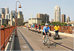
Biking around Minneapolis
On the breathtaking Grand Rounds, bicyclists soak up the scenery.
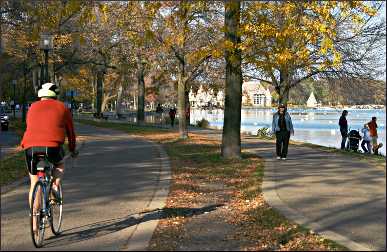
© Beth Gauper
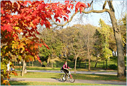
For more than a century, people have marveled at the Chain of Lakes in Minneapolis.
It's not so much the beauty of the lakes, though they're glorious. It's more the fact that ordinary folk can walk, bike, swim and play around them — all of them.
It almost wasn't so. Back in 1882, landscape architect Horace Cleveland had to argue his case for putting aside land on the city's lakes, creeks and river.
"Look forward a century, to the time when the city has a population of a million, and think what will be their wants," he wrote.
"They will have wealth enough to purchase all that money can buy, but all their wealth cannot purchase a lost opportunity, or restore natural features of grandeur and beauty, which would then possess priceless value . . ."
The city did buy land for parkways and boulevards, enough to put every home in Minneapolis within six blocks of green space, and we're enjoying it today — all million of us, it often seems on summer weekends.
Lined with bike trails, beaches, canoe rentals, band shells, golf courses and picnic pavilions, it's often called the best urban park system in America.
The Grand Rounds, the walking/biking/driving route that follows the parkways in a big circle around the city, is a national scenic byway.
Commuter trails in the city and from the suburbs have made it easier to reach by bike (for more, see Bicycling through the Minneapolis suburbs and Bicycling in St. Paul and beyond ).
For bicyclists, riding the Grand Rounds is unmatched adventure.
The south loop
The 17-mile southern route, around the Chain of Lakes, Minnehaha Creek and the Mississippi River, is very popular.
Before the Midtown Greenway was built, bicyclists had to cut through downtown if they wanted to ride the southern loop.
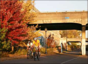
© Beth Gauper
Now they can use that below-street, east-west bicycle superhighway, paralleling 29th Street, to head south either from West River Parkway or Bde Maka Ska, formerly Lake Calhoun.
From Bde Maka Ska, the path heads south past Wheels of Fun canoe and kayak rental.
You'll pass a playground and beach before heading toward Lake Harriet and its Victorian bandshell, where free concerts are held daily in summer. There are more beaches on the east side of Harriet.
Then the path ducks into the enchantingly shady and secluded section along Minnehaha Creek between Lake Harriet and Portland Avenue, one of the few stretches with hills.
It continues east along the creek, between lakes Hiawatha and Nokomis. Then it passes Minnehaha Park; be sure to stop to see the famous Minnehaha Falls.
Then the path heads north along the Mississippi to the eastern end of the Midtown Greenway at East 27th Street. Head back to Bde Maka Ska, or continue through the University of Minnesota campus to the Mill District, Stone Arch Bridge and St. Anthony Main.
The north loop
Bicyclists also can use the Greenway to ride a 24-mile northern loop through Theodore Wirth Park and along the historic riverfront that's just as interesting as the lakes section.
From Bde Maka Ska, the Grand Rounds heads north along Dean Parkway and the west side of Cedar Lake. It crosses the highway, then plunges into Theodore Wirth Park, where the Swiss-born dean of Minneapolis parks is honored with a bronze statue, hand in hand with a bronze child, in front of the chalet.
The Eloise Butler Wildflower Garden and Bird Sanctuary, renowned for its spring ephemerals, and the Quaking Bog make fun stops in the park, which is 60 percent as large as New York's Central Park.
From there, the Grand Rounds follows arrow-straight Victory Memorial Parkway, where 568 trees were planted after World War I to honor fallen Hennepin County soldiers.
Unlike the rest of the Grand Rounds, the parkway doesn't follow a river, creeks or lakes; its wide-open green spaces were meant to serve as a firebreak.
© Beth Gauper
The route continues on Webber Parkway before crossing the Mississippi on the Camden Bridge, beneath which paved trails head north through bottomlands to North Mississippi Regional Park.
Then, they can either head east on St. Anthony Parkway or south on Marshall Street, along the river. The Northeast Minneapolis Arts District is centered around the handsomely preserved 1891 Grain Belt Brewery at Broadway and Marshall and along nearby 13th Avenue.
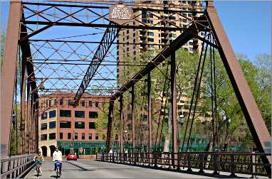
From the east side of the Broadway bridge, they can ride through Boom Island Park and across two trestle bridges to Nicollet Island and St. Anthony Main, whose renovated brick storefronts led the river renaissance in the 1970s.
This is the most historic part of the city. Parkland and beautiful trails line both sides of the 3½-mile loop from the Plymouth Avenue Bridge to J.J. Hill's graceful Stone Arch Bridge, once slated for demolition but now the most beloved pedestrian thoroughfare in town.
On the west side of the river, the Minnesota Historical Society operates the Mill City Museum at Mill Ruins Park.
Next to it, the Grand Rounds passes under the cantilevered lobby of the Guthrie Theater, its shimmering dark-blue facade embossed with towering images of George Bernard Shaw, Eugene O'Neill, Anton Chekhov and four other playwrights.
Two blocks south of the Guthrie, the Dinkytown Greenway starts behind the Red Cross building and takes bicyclists across the river and through the East Bank campus of the University of Minnesota to Williams Arena and TCF Bank Stadium.
From there, you can take the bike- and bus-only UM Transitway to the Fairgrounds in St. Paul.
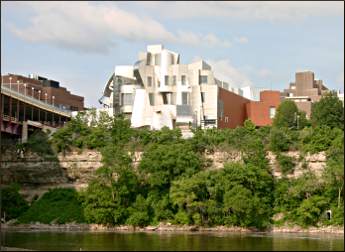
The Grand Rounds follows both sides of the river through the university campus, the east sporting the brassy Weisman Art Museum and the west the subdued glass flank of the Ted Mann Concert Hall.
River loops
Minnehaha Park is the starting point for several very scenic loops on the banks of the Mississippi River.
For a fairly easy 13-mile loop, ride over the Ford Parkway bridge to St. Paul and south along the parkway or bike/walking path and into Hidden Falls Regional Park. Paths follow the river through Crosby Farm Regional Park and on to the I-35E bridge.
Go under it and across, then head north on the Big Rivers Regional Trail to Mendota and across the Mendota Bridge.
Then you can either descend to Fort Snelling State Park and ride up the hill to Minnehaha Park or stay on the bluff, riding past the entrance to Fort Snelling Historic Site and along Hiawatha Avenue back to Minnehaha Park.
© Beth Gauper
A 22-mile loop starts in Minnehaha Park and goes the opposite way, down into Fort Snelling State Park, across the Mendota Bridge and along the river all the way to Harriet Island and downtown St. Paul, returning on Summit Avenue or on the Samuel Morgan Trail.
For details, see Twin Cities history ride.
Trip Tips: Bicycling around Minneapolis
Maps: A Grand Rounds map is available at the Longfellow House in Minnehaha Park and at rec centers and refectories along the route. There are also maps on kiosks all along the route.
Richard Fred Arey's handy "Twin Cities Bicycling" ($16.95, Minnesota Outdoors Press) contains a detailed, full-page map for the Grand Rounds and many other rides. It's available in bookstores.
Renting a bike: If you're visiting or don't have a bike, you can rent an e-bike or scooter from Lime, Spin or Veo.
Annual events: Mid-May, Art-A-Whirl studio and gallery tour along Marshall Street and nearby in Northeast Minneapolis. Mid-June, Stone Arch Bridge Festival. July 4, Minneapolis Red White and Boom on the riverfront, with music and fireworks. Late July, Aquatennial fireworks show.
© Beth Gauper
Music: On summer Sundays, time a bike trip to coincide with 2:30 or 5:30 p.m. concerts at the Lake Harriet Bandshell. Concerts are held daily on other evenings, generally at 7:30 p.m.
Minneapolis Parks also sponsors frequent concerts in Minnehaha Park and a few at Father Hennepin Bluffs Park on the east end of the Stone Arch Bridge.
Planning a route: The streamlined route — bypassing Lake Nokomis and Lake of the Isles, following the Mississippi to the St. Anthony Falls Heritage Area instead of riding through northeast Minneapolis — is 30 miles.
The loops around Nokomis and Lake of the Isles add three miles apiece.
If you ride the official route through northeast Minneapolis, skipping the St. Anthony Falls area, you'll ride 33 miles, including the 2½-mile gap from the Quarry to the river through the University of Minnesota campus.
Using the Midtown Greenway as a short cut allows riders to create two other routes. The southern part of the Grand Rounds, following the river and Chain of Lakes past Lake Nokomis, is a 17-mile loop using the Midtown Greenway, which meets the Mississippi at East 27th Street, by the trestle bridge.
© Beth Gauper
The northern part of the Grand Rounds is a 24-mile loop using the Midtown Greenway. From Webber Parkway, head south along the west side of the river and cross to the east side at Broadway.
Across from Bottineau Community Library, take the sidewalk to quiet Ramsey Street and on to Eighth Avenue. Head one block west and turn into Boom Island Park, where a paved path goes straight to a trestle bridge.
Cross the bridge (carry your bike up the steps) and ride onto historic Nicollet Island. At the other end, the 1887 Merriam Street trestle bridge crosses to the St. Anthony Main area.
From tiny Father Hennepin Bluffs Park, the Stone Arch Bridge crosses to Mill City Museum and the Guthrie Theater. From there, bike paths continue south along the Mississippi to Minnehaha Park.
Tricky bits: It's easy to follow the well-marked bike route, but there are a few tricky bits.
At the north end of Bde Maka Ska, several commuter trails converge. To head north on the Grand Rounds, ride a block on Dean Parkway, then take Cedar Lake Road up the west side of Cedar Lake.
(An alternative is to take the Kenilworth Trail up the east side of Cedar Lake, then head west on the Cedar Lake Trail to meet the Grand Rounds as it heads toward Wirth Park.)
© Beth Gauper
To close the loop from St. Anthony Parkway in northeast Minneapolis, keep going on busy Stinson Boulevard across East Hennepin, where Stinson turns into 18th Avenue. Turn west onto Como, then south on 15th Avenue at Van Cleve Park.
Keep going on 15th past Dinkytown and into the University of Minnesota campus to Pleasant Street. To continue on the west side of the river, cross the Washington Avenue Bridge; to continue on the east, turn right onto Arlington Street, before the bridge.
Highlights: At the east end of the Washington Avenue Bridge, stop by the stainless steel Weisman Art Museum ; admission is free. In Minnehaha Park, see Minnehaha Falls.
For a cool dip, stop at the beaches of lakes Nokomis, Harriet, Bde Maka Ska and Cedar. See the Rose Garden at Lake Harriet.
In Wirth Park, take a stroll in the Quaking Bog or Eloise Butler Wildflower Garden. On weekends, naturalists lead walks.
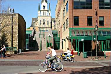
In the St. Anthony Falls area, visit the 1857 Lady of Lourdes Church, up the steps from Main Street on the east riverfront.
Ride across the Stone Arch Bridge and past the Mill City Museum and the Guthrie Theater. On Saturday mornings from early May to mid-October, there's the Mill City Farmers Market between the Guthrie and Mill City Museum.
For more, see On the river in Minneapolis.
© Beth Gauper
Repairs and rentals: On the Midtown Greenway at Chicago Avenue, the Freewheel Midtown Bike Center has a bike shop, plus bathrooms and showers.
In Minnehaha Park, Wheels of Fun rents bicycles and also surreys for up to four people. It's open daily from Memorial Day to Labor Day, weekends only in May, September and October.
Where to eat: When it's a beautiful day for bicycling, it's a beautiful day for eating outdoors, too. Each of these restaurants has an outdoor patio.
At East Lake Street and West River Parkway, the Longfellow Grill specializes in elaborate burgers but has all kinds of fun food. It's open for breakfast, lunch and dinner daily.
In the 1905 refectory in Minnehaha Park, Sea Salt Eatery serves inexpensive seafood, such as soft-shelled crab sandwiches and oyster po' boys. It's open daily for lunch and dinner.
On the beach on the north end of Lake Nokomis, Painted Turtle has replaced Sandcastle. (Watch for it; the main bike trail passes a block away from the lake.)
At Lake Harriet, Bread & Pickle serves sandwiches and treats plus breakfast.
© Beth Gauper
There's a Subway at the east end of Webber Parkway; for a picnic, buy some sandwiches and take them to eat at the river overlook in Marshall Terrace Park, at Marshall and 27th Avenue, or Gluek Park at Marshall and 19th Avenue.
Or eat at the Sample Room, which has a patio, at Marshall and 21st. In the St. Anthony Main area, bicyclists can eat outdoors at the Aster Cafe and Jefe Urban Hacienda.
For people who ride the official route and return to the river via 15th Avenue Southeast, Dinkytown has many places to eat.
Just off the Midtown Greenway at Chicago Avenue, the Midtown Global Market has all kinds of wonderful delis and restaurants.
Accommodations: The limestone Nicollet Island Inn, built in 1893 as the Island Door and Sash Co., is in the middle of everything. It has a restaurant and 24 individually decorated rooms, all with views and some with whirlpool.
Staying safe: The trail is nearly all off-road, but you still need to wear a helmet: You're much more likely to fall on your head by swerving or locking wheels with another bike than you are to be hit by a vehicle. And much of the trail is crowded on lovely weekends.
Information: The 1906 Longfellow House in Minnehaha Park, a 2/3-size replica of Henry Wadsworth Longfellow's home in Massachusetts, has maps and brochures about history along the route.
It's open Monday through Friday from 11 a.m. to 3 p.m., 612-230-6520. For maps through the mail, call 612-230-6400.