Rolling through the Iron Range
In northern Minnesota, Mesabi Trail draws bicyclists with scenery and machinery.
© Beth Gauper
The Iron Range never has been for anyone who didn't want to sweat.
Ever since iron ore was discovered on the shores of Lake Vermilion, this strip of Minnesota has drawn people who wanted to work.
One of the world's richest deposits of iron ore lay under the forest, and waves of Finns, Slovenes, Italians, Swedes, Croatians, Poles, Germans and Serbs came to shovel it out.
On the Vermillion Range, hard ore lay in vertical shafts, and the Soudan mine near Ely eventually reached seven football fields into the Earth.
To the south, softer ore lay along a wooded ridge of hills, an exposed stretch of the Laurentian Divide that the Ojibwe called the sleeping giant, or Mesabi.
The Mesabi Range runs nearly 120 miles, from just east of Grand Rapids to Hoyt Lakes, and its ore could be dug out of open pits.
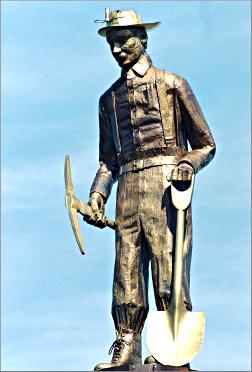
The miners worked hard to move all that rock. Their labor also built dozens of towns, helped the nation win two world wars and made mine owners very rich.
The Rangers didn't get rich, but their lives were enriched by their fellow miners' cultural contributions: polka from the Poles, progressive politics from the Finns, walnut potica from the Slovenes.
Today, the Iron Range is one of the most interesting but overlooked parts of Minnesota. It has natural lakes as well as mine-pit lakes, which often are lovelier — emerald-green, lined with red cliffs and stocked with trout.
It offers tours of played-out mines as well as views of working mines. Its kitchens make dishes found nowhere else in the state — pasties, potica, sarma.
And now, it has the Mesabi Trail.
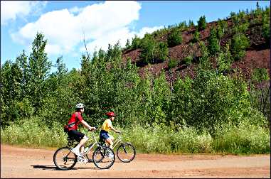
This asphalt-paved bicycle trail, like the Range itself, isn't for sissies. Only part of it lies along abandoned rail lines; the rest climbs hills and dips and dodges around an intriguing mix of natural and manmade topography — bogs and slag heaps, rock cuts and aromatic stands of pine.
© Beth Gauper
Birds, it turns out, like this landscape: Osprey nest on power poles at the edge of old mine pits, peregrine falcons perch along their red cliffs, and loons have taken up residence on the quiet lakes.
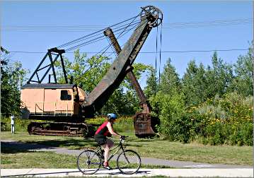
This area always has been part of Minnesota's beautiful north woods — there just happened to be money buried under the trees. That's why, today, bicyclists will round a corner to see a lovely clump of wildflowers — with an abandoned steam shovel planted in the middle of them.
Muscle-powered vehicles weren't found on the Range until recently; it's more the habitat of 300,000-pound dump trucks, one of which can be seen just off the trail at Virginia's Mineview in the Sky.
But in the early 1990s, a citizens group in Itasca County began talking about a trail, about the same time the St. Louis & Lake Counties Regional Railroad Authority was thinking about extending its North Shore Scenic Railroad up to the Range.
The rail authority quickly decided to concentrate on a trail instead; it joined forces with the Itasca County group, the Itasca County Rail Authority and other citizens groups.
They came up with a dream route — 132 miles, past every Iron Trail attraction and state park between Grand Rapids and Ely — and hired Bob Manzoline to be St. Louis & Lake Counties rail authority director and oversee the creation of the Mesabi Trail.
It seemed to be a Sisyphean task — the part of the route now finished or under construction includes 700 parcels of property, much of it owned by absentee mining corporations.
But amazingly, Manzoline and a citizen's committee have assembled enough land and cobbled together enough federal, state, regional, county and local grants to build more than 135 miles of paved trail.
The first time I rode the trail, I started from Virginia. Just south of town, the trail passed the Village of Franklin, the site of six towns, or "locations," that by 1948 had been consumed by the Rouchleau Mines.
The mines started shipping ore in 1893 and soon became one of the many Minnesota mines swept into the financial empires of John D. Rockefeller, Andrew Carnegie and J. Pierpont Morgan.
A cage at the site provides a view of the 3-mile-long pit — try to spot the osprey nest — but bicyclists who don't mind an extremely steep climb can get a better view from Mineview in the Sky, which the trail soon passes.
They'll have to climb no matter what, past the base of the slag mountain on which the observation center sits and beyond, through picturesque rock cuts that rival those on the Carlton and Root River trails.
© Beth Gauper
Then the trail emerges onto an elevated berm, with a boggy lake on one side and mountains of waste rock on the other. From there, it passes a stand of shimmering popple, a patch of purple aster and beach pea and Ely Lake, scraped out not by graders but by glaciers.
Coming into Gilbert, I briefly shared the road with trucks from the ISPAT mine, then cruised down the town's wide main street, lined with banners bidding welcome in other languages, from "Hallo" to "Pozdravijeni."
Squat brick buildings line the wide street. On the edge of town, Lake Ore-Be-Gone occupies a pit from which three mines shipped out 35 million tons of ore between 1902 and 1981.
It's next to the Sherwood Forest Campground, from which the trail winds through woods to Eveleth and Fayal Pond.
From downtown Virginia, the path uses white diamonds to lead bicyclists through Olcott Park, past the cemetery and up to Mountain Iron, named for the Merritt brothers' 1890 declaration that they had discovered "a mountain of ore."
The Merritts shipped the Mesabi's first ore out of Mountain Iron, but lost their mine to John D. Rockefeller, whose U.S. Steel still owns the Minntac taconite operation, the world's biggest.
© Beth Gauper
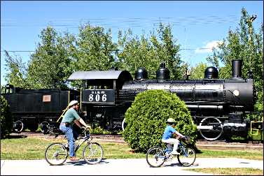
Bicyclists can see it from the park on its edge, where there's a 1910 locomotive, a steam shovel and a little pavilion.
From Kinney, I rode west through a corridor of trees to Buhl, past a mine-pit lake whose red cliffs reflected off its blue-green waters like the bands of an agate.
On the other side of town, I passed a rusty Bucyrus Erie steam shovel in the old Grant location, near an old head frame and an odd apparatus with a suspended set of tires — artifacts from a world unfamiliar to the white-collar set.
The trail passes Stubler Beach, on another mine-pit lake, and goes on to Chisholm, passing a series of grassy pyramidal hills — waste rock, being reclaimed by nature — and going up a steep 8 percent grade to the crown of the hill overlooking Chisholm.
It wasn't as hard as swinging a pick axe, but it took some work. Soon, the trail deposited me in the parking lot of the Minnesota Discovery Center museum complex, and I went inside for some cold water.
The stretch to Hibbing is fairly flat, but west of Hibbing the trail climbs.
"It's like riding into the Pyrenees mountains in France," says the trail's Doug Schmitz. "It's just amazing — you can see working taconite mines in the distance; you can see all of St. Louis County up there."
It's a heck of a trail — of course, I actually like hills and sharp corners, and I even like steam shovels in my wildflowers.
Trails that meander sedately through fields and forest, are nice, too, and on those bicyclists don't have to sweat for their scenery. But I can tell you one thing: If you ride the Mesabi Trail, you won't be bored.
Trip Tips: Mesabi Trail in northern Minnesota
Getting there: It's three hours to Eveleth, via Cloquet, from the Twin Cities.
Riding the trail: There are 75 continuous miles between Grand Rapids and McKinley, plus a four-mile spur from Gilbert to Eveleth; 24 miles from Biwabik to Giants Ridge and past Embarrass, plus a four-mile spur to Aurora; and 17 miles from Tower to Soudan and on toward Ely.
© Beth Gauper
In Grand Rapids, the trail starts at the Itasca County fairgrounds, on the northern edge of town.
For a trail map, call 877-637-2241. A Wheel Pass, $10 for three days and $20 annually, can be bought online or from local businesses and visitor centers.
Bike tour: In early August, the Mesabi Trail Tour includes routes on portions of the trail.
Accommodations: Giants Ridge has villas overlooking Wynne Lake and lodge rooms at the foot of the ski hill.
Lake Vermilion-Soudan Underground Mine State Park offers eight camper cabins as well as campsites.
Camping: Stubler Beach Campground, right on the trail in Buhl, has eight tent-only sites and a swimming area.
McCarthy Beach State Park near Side Lake is 20 miles north of Hibbing.
Many of the campgrounds in the area, such as Sherwood Forest near Gilbert, cater to ATV riders.
Dining: There are many places to eat in larger towns, but smaller ones have only a bar or two, so bring snacks and water while riding.
In Hibbing and Eveleth, BoomTown Woodfire serves a large menu of grilled burgers and steaks, plus salads, pastas and its own craft beer.
In Gilbert, the Whistling Bird serves a large menu of steaks, shrimp and pasta, many with Caribbean accents.
In Biwabik, Vi's Pizza is popular.
Attractions: Check out the excellent tours at Soudan Underground Mine State Park and Hill Annex Mine State Park in Calumet.
For more, see On the Iron Trail.
Bike rental: In downtown Hibbing, Bikes on Howard rents bikes and does repairs, 218-262-0899.
Information: For a Mesabi Trail map, call 877-637-2241.
For a visitors guide, contact Iron Trail tourism.