5 great hikes in Minneapolis
See the best of this beautiful city on these short but sweet walks.
© Beth Gauper
When you're a tourist, you don't always want to get "off the beaten path."
We visited Portland, Ore., for the first time one Labor Day, and all we knew is that it's an outdoorsy town. So we were looking for a nice hike in Forest Park, one of the nation's largest municipal forests with 80 miles of hiking trails.
Wow! Except we only needed four or five of those miles. Surely, we thought, there's a "best hike" that all the locals know about. Nope — our guidebook, maps and the local hikers forum were useless.
Now we understand that first-time tourists don't need or have time for the whole smorgasbord — they'd just like to try one or two signature dishes.
So here's our Minneapolis version of what we were looking for in Portland: five hikes that are scenic, easy to find and show off the city at its best.
All of them take about an hour and can be extended easily. And they're all along Grand Rounds National Scenic Byway, which makes a big loop around the city.
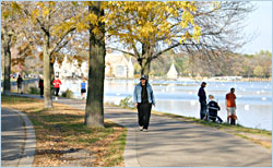
Lake Harriet loop
This is the hike I thought of longingly when we were searching for a Portland hike. It's three miles around and unfailingly beautiful, with a Victorian-style bandshell, two family beaches, a rose garden and water dotted with sailboats.
There's a free concert nearly every summer night, boat rentals, the Bread & Pickle cafe, a restored streetcar that travels the few blocks between Harriet and Calhoun and a playground on the hill above the bandshell.
Idyllic? Pretty much. There's no better way to spend an afternoon in the Twin Cities.
How to get there: There's a pay parking lot on the north end, near the bandshell. From downtown, take I-35W to 36th Street and go west to Lake Calhoun. Follow Calhoun Parkway south, turning left on William Berry Drive. It's .4 mile to Lake Harriet.
© Beth Gauper
The north lot often is jammed, though there's parking on nearby streets.
To approach from the less-congested south, take 50th Street west from I-35W to Lynnhurst Park, either parking there or on streets around South Beach, a quarter-mile away.
There also are pull-outs along Lake Harriet Parkway (traffic goes counter-clockwise) and spots along the Rose Garden.
Extending your hike: It's another 3½ miles up and around Bde Maka Ska/Lake Calhoun on the Chain of Lakes. Or, head east of Lake Harriet along Minnehaha Creek.
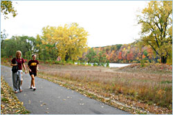
Minnehaha Creek from Lynnhurst to Portland
On this two-mile stretch of the Grand Rounds, you'll be surprised you're in the middle of a metropolitan area of more than 3 million. The shady walking trail winds away from the bicycle trail but closely follows Minnehaha Creek, often crossing it on graceful wrought-iron bridges.
Traffic on some of the city's busiest streets stays overhead, leaving the trail quiet and secluded as it winds through the Tangletown neighborhood.
How to get there: Park at Lynnhurst Park on 50th Street (see Lake Harriet Loop, above) or on Portland Avenue and 50th Street, where you'll find a giant bronze bunny.
Looking for a winter hike? When Minnehaha Creek is frozen, it's a great place to snowshoe.
Minnehaha Falls to the Mississippi River
Minnehaha Falls, where Minnehaha Creek tumbles 53 feet into a sandstone-lined bowl, has been a tourist attraction since the first steamboat carried tourists up the Mississippi in 1820.
But it became famous after the 1855 publication of Henry Wadsworth Longfellow's 'Song of Hiawatha," and the pennies of schoolchildren paid for the Jacob Fjelde's 1911 statue of Hiawatha preparing to carry the maiden Minnehaha across the water.
A stone stairway leads to the bottom of the falls. From there, a wooded walking trail lined by crumbling sandstone bluffs follows the creek on both sides to the banks of the Mississippi River.
© Beth Gauper
At dusk, the creek often is lined with egrets looking for fish.
In the park, there are bike rentals, an ice-cream stand and the popular Sea Salt seafood eatery.
How to get there: There's plenty of parking in lots around Minnehaha Park, which also is easy to reach by light rail. The Blue Line's 46th Street stop on Hiawatha Avenue/Minnesota 55 is half a mile north of the park.
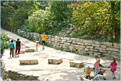
Mississippi River flats
The gorge between downtown Minneapolis and downtown St. Paul is the only one along the Mississippi, and there are trails along its wooded sides as well as on East and West River Parkway.
It's a 2½-mile loop between the Franklin and Washington bridges through the University of Minnesota campus. Start on the southeast end of the Franklin Bridge, descend a staircase and walk north on an elevated walkway over the river.
From the university's boathouse in East River Flats Park, walk up (or take the elevator from the river road) to the Frank Gehry-designed Weisman Art Museum, where admission is free.
Cross the Washington Avenue Bridge, follow the marked trail through the campus and walk past the Ted Mann Concert Hall back to the river.
How to get there: Park on Franklin Avenue or city streets on either side of the Franklin Bridge. Spots closer to the university are metered.
© Beth Gauper
Extending your hike: It's another three-mile loop from the Franklin Bridge to the Lake Street Bridge. From the southeast east end of the Franklin Bridge, descend the staircase to a wooded trail that follows the river for ¾ mile before returning to East River Parkway.
On the southwest end of the Franklin Bridge, you can drop into the woods that line the gorge by following the Winchell Trail, which passes a large white-sand beach.
If you're willing to do a little bushwhacking, you can walk in woods all the way from Franklin to the rowing-club boathouse at Lake Street and on to 44th Street.
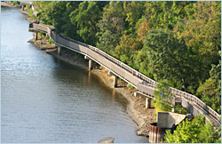
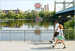
St. Anthony Falls Heritage Trail
It's hard to believe the 1883 Stone Arch Bridge, with 23 arches that gracefully curve as they cross the river below St. Anthony Falls, almost was torn down after rail traffic ended.
Today it's the beating heart of the city, carrying throngs of bicyclists, runners and walkers between the museum-theater Mill District and the St. Anthony Main dining-entertainment district.
It's a 3½-mile loop on walking trails from the Stone Arch Bridge to the Plymouth Bridge. The walk to the Broadway Bridge adds a mile.
© Beth Gauper
You'll see the greatest hits of Minneapolis on this riverfront loop, starting with Mill City Museum and the Guthrie Theater. On West River Parkway, the path passes the Federal Reserve and a playground at 4th Avenue, six blocks east of Target Field.
Just north of the Broadway Bridge, the Twin Cities River Rats water-ski team performs free shows on Thursday evenings in summer. On the east end of the bridge, turn onto Ramsey Street, walk to 8th Avenue and turn right toward Boom Island Park.
On the south end of the park, a 1901 trestle bridge leads to wooden steps that will take you to Nicollet Island and some of the city's oldest houses, including 1877 French Second Empire stone rowhouses on Grove Street.
Pass under the Hennepin Avenue Bridge, where the first bridge across the Mississippi was built, to the pavilion, where more trails wind around the south end of the park.
An 1887 trestle bridge crosses the channel to St. Anthony Main; look up and you'll see the 1857 Lady of Lourdes, the city's oldest church. Turn right onto a cobblestone path that leads to Water Power Park, where you can walk to the river's edge and read about the milling era.
Just past Water Power Park, you can take the Lower Trail down to the river, in the old mill runoff area. Up on the bluff, the trail continues to Father Hennepin Bluffs Park and back to the Stone Arch Bridge.
How to get there: Park on city streets or at Boom Island Park. If you park around heavily monitored St. Anthony Main, carefully read the meter and watch your time.