River with a past
On the lush Minnesota, beautiful scenery comes with harsh history.
© Beth Gauper
Around the world, people know Minnesota for its waters — source of the Mississippi, land of lakes.
But those are not the waters for which it's named. Those waters belong to a river whose cloudiness led the Dakota to call it "waters reflecting the skies" — the Minnesota.
It was more than a mile across at the end of the last ice age, when it drained glacial Lake Agassiz, the largest lake that ever existed.
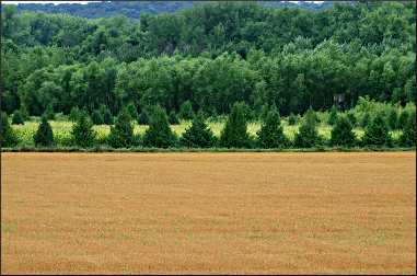
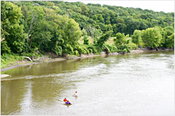
Today, the Minnesota is small and sluggish, and farm runoff and erosion have increased its natural siltiness. But the river's broad valley, reaching from the South Dakota border to the Twin Cities, is beautiful.
Game roamed its banks, and waterfowl nested in its marshes, which drew the Dakota. Some of the richest farmland on Earth lay under its tall prairie grasses, which drew settlers.
It was a hot property — and the eventual battle over it marked the state forever.
But today, too few Minnesotans know of the events that sent shock waves across the frontier in 1862. Too few come to visit its towns and historic sites, its parks and wildlife refuges.
"There's sort of a dismissive attitude — 'This is not lake country,'" says David Minge, a retired Minnesota Court of Appeals judge who represented the area in Congress for eight years.
For nine years, Minge hosted bicycle tours for friends on Labor Day weekends, showing them the scenic spots and interesting people he'd discovered over the years.
Then, he had the idea to hold a public ride under the auspices of the Parks & Trails Council of Minnesota, so more people could go along. Historians, land stewards and other experts would meet them along the way, and riders would see the valley at its best.
"I wanted to show other people what I had had the opportunity to see," he said.
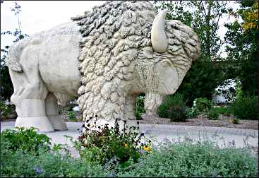
From Ortonville, the Minnesota River flows through the sloughs of Big Stone Lake National Wildlife Refuge, where bison roam in a restored tall-grass prairie, and into Marsh Lake, which has the largest colony of pelicans in the lower 48 states.
From Lac Qui Parle, a 12-mile bulge in the river, it passes Granite Falls and Montevideo, settled by Norwegians, and New Ulm, a town of Germans.
History is everywhere: at the Harkin Store, frozen in 1870, and at the many sites that figured in the Dakota Conflict of 1862: the Upper Sioux Agency, the Lower Sioux Agency, Birch Coulee, Fort Ridgely.
In Mankato, the Minnesota River veers north to St. Peter, which sprang up around a natural ford called Traverse des Sioux and became the spot where the Sioux, or Dakota, were forced to give up 24 million acres in southern Minnesota in the first of two 1851 treaties.
© Beth Gauper
Then, the Minnesota winds north and then east, flowing into the Mississippi below Fort Snelling, a gathering spot long before Lt. Zebulon Pike chose it as the site for a fort in 1805.
In 1862, an explosion
Today, the river itself is rarely seen by motorists who travel its highways, built on the valley's edges. But its presence is felt by anyone who knows its history.
In 1862, it was at the center of a cataclysmic event that still colors relationships in the valley: "The anger and hatred is so bad I don't think we'll ever find the truth about what happened," said David Larsen, former chairman of the Lower Sioux Dakota tribal council.
At Fort Ridgely, it was Larsen who welcomed Minge's bicyclists to the Minnesota Valley.
"I want you to know honestly who we are as you ride through this area," he said. "You're riding through Mother Earth; what affected us will affect you."
Admiring as sightseers will be, traversing the lush valley, they must acknowledge a harsh truth: Every farm, every town, every highway was built at the expense of the Dakota.
In 1862, emigrants from foreign countries were streaming into Minnesota to claim free land under the Homestead Act. The natives, however, were confined by treaty to a 10-mile-wide strip south of the Minnesota River.
Crops had failed the previous year, and by June, the Dakota were starving, but they put off their annual buffalo hunt in the West to wait for the annual payment promised under the treaties.
But the gold was late, held up in a Washington drained by the Civil War. At the Lower Sioux Agency, an arrogant new agent refused to release all the food and other provisions also due to them until the gold arrived.
The gold, two months late, had nearly reached Fort Ridgely when four young men, on a dare over the theft of eggs, shot and killed five settlers.
Despite the prophecies of their eloquent leader, Little Crow — "The white men are like locusts when they fly so thick that the whole sky is a snowstorm . . . kill one, two, 10, and 10 times 10 will come to kill you" — the Dakota, already in trouble, decided to try to drive out the settlers.
In the next six weeks, they killed at least 360 settlers and traders; Andrew Myrick, a trader who had said, "Let them eat grass," was found with his mouth stuffed with grass.
No one knows how many Dakota were killed fighting U.S. soldiers, about 90 of whom died.
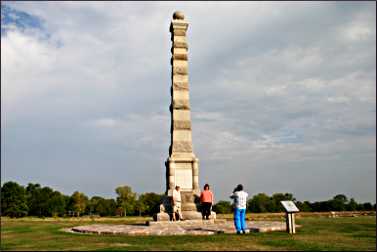
But the conflict ended that December with the hanging of 38 warriors at Mankato, the cancellation of all treaties and debts and the removal of the Dakota to Fort Snelling and then to barren reservations in South Dakota, where many died.
David Minge remembers learning about the conflict as a boy in Worthington.
© Beth Gauper
"It's such a tragic tale," he says. "In fifth grade, you learn about this agent who said, 'Let them eat grass,' and to a 10-year-old, that's pretty graphic. The story about how it started and how it unfolded is so dramatic."
But today, many school curriculums don't include the conflict, and many of the historic sites that explain it have been hobbled by budget cuts.
Digging for history
But people make their way there, anyway. When I was at Fort Ridgely, visitors included Jody Hruby of nearby Madelia, who had brought her two young daughters.
"I don't think they teach enough history," she said. "I love Indian culture. I study it. I believe they had such a hard life. We need to keep the history alive, because I think it goes by the wayside. So, I take my children to places like this."
Outside, Genie Simon of nearby Sleepy Eye was showing the reconstructed foundations of the barracks to her sister, visiting from Florida.
"I live in this area, and you have to dig for the history," she said. "If you talk to local folks, they don't know.
"If you want to know, you have to get the books and read, but it isn't in just one book. We haven't captured it like we should. But the natives at Lower Sioux, if you start talking to them, they have all kinds of stories to tell you. It's real interesting."
For the bicyclists, the past was never far away. Riding west, the group reached the Lower Sioux Agency, where David Larsen again spoke.
© Beth Gauper
"Until 1978, it was illegal to talk about our way of life," Larsen said. "We couldn't even sing legally or use sweat lodges or do a sun dance. In this area, 99.5 percent of people don't know us; we're suffering still today from ignorance."
The interpretive center on the former trading post, the first to be attacked in August 1862, is the best spot to learn about the conflict and Dakota culture.
Mary Gross of Redwood Falls was there working as a volunteer.
"When I first moved here in 1984, I heard David speak, and I thought, 'Oh, I don't like to hear that,' " she said.
"But it's something everyone needs to hear. Then, I started to read and learn more, and I found out everything I knew was wrong. And as Dave says, not that much has changed."
Pioneer or profiteer?
In Redwood Falls, former mayor Gary Revier welcomed the group to lovely Alexander Ramsey Park, which is the largest city park in Minnesota, with waterfalls and its own zoo.
Once a haven for the Dakota, the park was named for the man who "did more to hurt the native American people than anyone," he said.
Acknowledging the slippery aspects of history — "80 percent is written or spoken word, and 20 percent is out there being interpreted as people want to" — Revier gave a condensed version of frontier events.
© Beth Gauper
Ramsey, he said, was only one of the many traders and politicians who profited handsomely from the Dakota: "They tried to destroy a way of life because of their greed, and now they have towns named after them," he said.
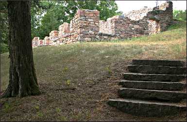
Farther along the river, the group came to the ruins of a prairie castle, built by Joseph R. Brown in 1861, shortly after he left his lucrative post as Lower Sioux Indian agent, and burned during the conflict.
The 19-room mansion of rose granite was built into the hillside to catch breezes off the river and had a baby grand piano and billiard tables. It begged the question: Was Joseph Brown a good guy or a bad guy?
"Lots of people said if he had been Indian agent at the time, there wouldn't have been a conflict because he knew how to deal with Indians," said Lois Enestvedt, one of the locals who are trying to restore the house.
"He was quite a man — a statesman, an Indian trader and a newspaper editor, and he founded the towns of Henderson and Browns Valley."
Fox snakes had used the stones to scrape off old skins, which dangled from crevices by the dozen. Riding along the river, through Skalbakken Park, riders spotted a variety of wildlife: blue heron, pheasant, turkey vulture, red-tailed hawk, red-bellied woodpecker.
As they rode to the former Upper Sioux Agency State Park, at the confluence of the Yellow Medicine and Minnesota rivers, a bald eagle was circling overhead.
Many of the Dakota who lived around Upper Sioux Agency were farmers, derisively called "cut-hairs" by those who did not want to abandon their traditional lifestyle, and they were among the many Dakota who helped settlers escape during the 1862 war.
© Beth Gauper
From the Upper Sioux, riders rode to Granite Falls, then along the Wegdahl Trail into Montevideo.
From Montevideo, it was a short ride to Lac Qui Parle Mission, built on the site where Joseph Renville, a respected trader whose mother was Dakota, welcomed missionaries from the East in 1835 and helped translate the Bible into Dakota.
His wife was the first Dakota convert, and at one time more than 80 people attended the church, but the mission's influence waned after Renville's death in 1846.
In some ways, said John LaBatte of New Ulm, the Dakota and the Christians had much in common.
"Hospitality, generosity and charity was expected in both religions," he said. "They believed virtue was not in what you had but in what you could share."
In the Minnesota River Valley, waters run deep, and weekend visitors can expect only to skim the surface. But if you want to know the state, you also have to know the river.
Trip Tips: Conflict in the Minnesota River Valley
Getting there: From the Twin Cities, it's about 1½ hours to St. Peter, the first stop on a history tour of the valley.
Planning a trip: For a copy of the handy Minnesota River Valley Scenic Byway map, email or call 888-463-9856.
For information on the Upper Minnesota River, call Prairie Waters tourism, 866-866-5432. A Minnesota DeLorme Atlas & Gazetteer is helpful in finding sites.
For more about the history, see Mourning the summer of 1862.
© Beth Gauper
Annual events: Second weekend in June, Lower Sioux Wacipi in Morton. First weekend in August, Upper Sioux Wacipi in Granite Falls. Weekend after Labor Day, Rock Bend Folk Festival in St. Peter. Third weekend in September, Mahkato Wacipi in Mankato's Land of Memories Park. First weekend of October, Meander, the Upper Minnesota River Art Crawl.
Treaty Site History Center in St. Peter: This center on the north edge of town off U.S. 169, contains copies of the "trader's papers" that allowed white men to siphon off virtually all the money the Dakota received under 1851 and 1858 treaties.
Mankato: The site of the 1862 hanging is marked at Reconciliation Park, off Riverfront Drive.
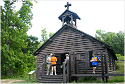
Harkin Store between New Ulm and Fort Ridgely: This isn't a Dakota Conflict site, but the restored 1870s general store, with costumed staff, is a fun place to visit. It's on the north side of the river, on County Road 21, eight miles northeast of New Ulm.
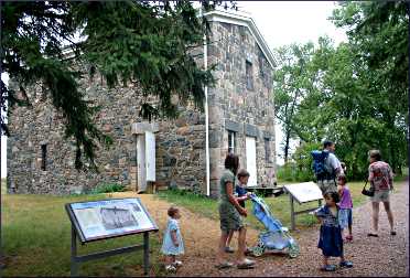
Fort Ridgely: The historic site is in Fort Ridgely State Park, seven miles south of Fairfax off Minnesota 4. Admission is free.
Lower Sioux Agency Historic Site: This Minnesota Historical Society site is nine miles east of Redwood Falls. It's open Fridays-Sundays from mid-April to mid-October.
Birch Coulee Battlefield: This beautiful restored prairie is where Dakota warriors surprised a burial party sent from Fort Ridgely, in a battle that became the biggest setback for U.S. troops in the 1862 conflict.
Self-guided trails and displays explain events. It's three miles north of Morton at the junction of county roads 2 and 18, one mile east of U.S. 71.
Upper Sioux Agency State Park:: The park has been returned to the Upper Sioux Community and is closed to the public.
Lac Qui Parle Mission: It's eight miles northwest of Montevideo on County Road 13, off U.S. 59. Admission is free.