Marvels of Starved Rock
In northern Illinois, a state park draws crowds to its forest canyons and riverside cliffs.
© Beth Gauper
Like many places, Starved Rock State Park has a name whose origin is lost in the mists of time.
Supposedly, the Potawatomi and Ottawa trapped a band of Illini on a 125-foot butte along the Illinois River. However, anyone who's actually climbed up Starved Rock — and millions of tourists have — can see that no one could defend it long enough to starve.
"It's like Paul Bunyan and Babe the Blue Ox," says Kathy Higdon of the Illinois Waterway Visitor Center across the river. "It's a legend, like the Lover's Leaps we've got all over the place."
Carved Rock would make more sense. At the end of the last Ice Age, a flood of glacial meltwater ate away the softest rock along its path, turning the riverside cliffs into Swiss cheese.
The water also cut a string of 18 canyons, which seem like mirages in the middle of Illinois farmland.
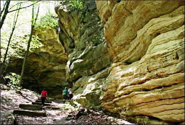
Easily reached by park trails, they're cool refuges with towering walls of sandstone, carved in the eerily skeletal style also seen in underground caves. From clefts atop cliffs, water cascades into pools, some with beaches of white sand that has sloughed off the soft walls.
These canyons have drawn visitors ever since Marquette and Jolliet passed by on their way back from the Mississippi in 1673.
Across the river, the French explorers found a village of 1,000 hospitable Illini farmers, for whom their arrival marked the beginning of the end.
The Illini began to die of European diseases, and the fur post the French established drew hostile Iroquois armed by the English. After less than 20 years, they fled south.
The tourism era at Starved Rock began when an entrepreneur built a Victorian hotel and dance hall along the river at the turn of the 19th century. It struggled, and in 1911, he sold the land to the state for a park.

© Beth Gauper
During the Depression, Civilian Conservation Corps workers built roads, bridges and trails, and also a timber lodge and cabins on the bluff.
The lodge has been embellished and expanded over the years, and now guests can forgo the outdoors and spend their time getting a massage, lounging in the sauna, listening to live music, taking trolley tours and dining in the timber-beamed Great Hall.
Down by the river, day trippers like to hang out on the rolling lawn of the Visitor Center, grilling, playing Frisbee and eating ice cream from the concession stand.
But Starved Rock's magic is in its canyons. The closest to the lodge is St. Louis Canyon, less than half an hour by foot along the Bluff Trail.
Spring is gorgeous at Starved Rock, and on Mother's Day, so many spring beauties were blooming that the grass and forest floor looked sprinkled with white confetti.
The first canyon I passed was Aurora, a narrow slot with golden walls only partly visible from the trail. From there, the trail wound up to the blufftop, and I could see the town of Utica across the river.
At my feet I saw a clump of jeweled shooting star, then another, and another. It was one of the best displays of this elegant wildflower I've seen; it's not rare, but it's not common, either.
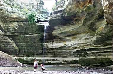
From the bluff, the trail wound down and around to St. Louis Canyon. It was a shady, rock-lined room in the middle of forest, with a stream of water tumbling from the clifftop into a pool. Teen-agers sank onto a downed log and stared at it, mesmerized, and smaller kids darted in and out of shallow caves in the rock walls.
I had to get back for the Sunday trolley tour, which gives an overview of the park, the town of Utica, the Illinois & Michigan Canal and the Illinois Waterway Visitor Center.
The center adjoins the Starved Rock lock and dam, one of eight that take barges over the 163-foot drop from Lake Michigan to the Mississippi.
The driver supplied us with an eclectic narration that was stronger on personal experience and opinion than context and history; people who prefer dates and facts will have to dig them up later.
© Beth Gauper
We did learn about the Utica buildings destroyed in a 2004 tornado, the 1960 murders of three women in St. Louis Canyon and the history of the I&M Canal, as read off the plaque in front of the Lasalle County Historical Museum.
I would have liked to hear about the 61½-mile crushed-limestone bicycle trail just on the other side of the canal. It follows the former towpath, now a national heritage corridor, all the way from nearby LaSalle to the edge of Joliet. It looked inviting.
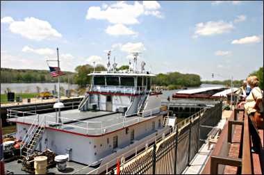
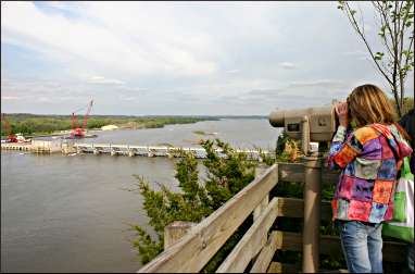
Instead, we headed east along the river to the Illinois Waterway Center, where we watched the towboat Terri C. being lowered 19 feet toward Peoria.
The center's Kathy Higdon was more informative, telling me about river traffic — the most common cargo is chemicals, she said — and the six tribes of the Illini confederacy. Archaeologists have found a trove of artifacts just upriver at the Grand Village of the Kaskaskia, a national historic landmark that's closed to the public.
The rock columns of Starved Rock and Lover's Leap were right across from us, and Plum Island rose from the river in terraces.
That's where the Kaskaskia farmed, Higdon said; now, it's owned by the Audubon Society and is a sanctuary for bald eagles, who like to pick off fish at the bottom of the dam.
© Beth Gauper
Back in the trolley, our driver told us the tired old story of Lover's Leap and the doomed love of an Indian brave and maiden. He added, "Every four or five years, some drunk will jump off it and break a leg. They don't die, but they do get arrested."
That I believed. Our next stop was the park visitor center, where we were supposed to see a short movie. But it was unavailable, so our driver passed out slivers of fudge instead.
After the tour, I drove to the three canyons on the east end of the park. The first stop on the trail was Council Overhang, a gigantic natural bandshell with striated walls of yellow and white sandstone and black smoke stains where, presumably, councils were held.
At Ottawa Canyon, the cliffs were so soft they were turning into sand, with grains clinging to their surface like sawdust.
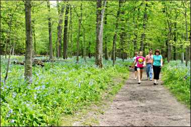
Bluebells created a blue haze on the moist canyon floors and lined the streams, mingling with horsetail rushes. Stray buttercups added a waxy splash of yellow, and I spotted a robust Jack in the pulpit.
Children played at the edge of a shallow, muddy pool. In Kaskaskia Canyon, the pool was deeper and clear, and ferns cascaded off the north-facing wall. A glaringly white patch showed where a slab had fallen to the ground; already it was a pile of sand.
These mysterious little niches full of rock, sand and water are a kids' paradise. Parents in the know had given their children Crocs or old sneakers to wear, because nagging is just cruel when there's so much for a kid to explore.
I wished I had water sandals myself at Illinois Canyon, reached only by fording several streams on haphazardly arranged bridges of branches and rocks. It's an adventure, though; at one point, I heard cheers behind me as a group successfully crossed.
Illinois Canyon is a long, oval bowl with rock outcroppings the size of a beached ocean liner. When I finally made my way to the inevitable pool at its far end, I smiled when I saw Jack and Annette Hovland, whose path I'd been crossing all day.

© Beth Gauper
The Muscatine, Iowa, couple also were visiting Starved Rock for the first time.
"This is amazing," Annette said. "I don't know why we didn't take our kids here when they were young."
The park was founded in 1911. It's long been a favorite of millions, but word still is spreading fast.
Trip Tips: Starved Rock State Park in northern Illinois
Getting there: The park is across the Illinois River from Utica, just south of Interstate 80. It's 95 miles from Chicago.
On summer weekends, parking lots often fill by midday, so go early in the day.
When to go: In spring, waterfalls tumble into canyons filled with Virginia bluebells and other wildflowers.
© Beth Gauper
In summer, the canyons stay cool. In fall, the hardwood forests provide color. The park becomes extremely busy on October weekends, and parking areas fill quickly.
In winter, there are ice falls in the canyons, and as many as 75 eagles congregate around the dam, where water stays open.
Admission: Like all Illinois state parks, it's free.
Annual events: Late January, Eagle Watch Weekend. Mid-September, Vintage Illinois Wine Festival. Early October, Burgoo Festival in Utica.
Accommodations: Starved Rock Lodge & Conference Center rents knotty-pine paneled rooms in the East Wing, built in the 1930s, and more modern rooms in the West Wing, completed in 1989. Saturday-night reservations require a two-night stay.
Near the lodge, deluxe cabins house two people, and some have wood-burning fireplaces. Pioneer doubles cabins are big enough for four, and pioneer family cabins have two bedrooms and gas fireplaces and occupy five.
© Beth Gauper
Across Illinois 178 from the state park, Grand Bear Resort has a small indoor water park and an indoor amusement park in a boxlike separate building.
Five miles south of Starved Rock, Camp Aramoni offers luxury camping in safari tents.
There are many chain motels and other lodgings in the nearby towns of LaSalle, Ottawa, Peru and Oglesby.
Camping: There's a park campground a mile from the lodge, on the other side of Illinois 71. It has showers, flush toilets and a small store.
Dining: Starved Rock Lodge has fine dining in its Great Hall, more casual food in its Back Door Lounge & Veranda and coffee, snacks and sandwiches in its cafe.
August Hill Winery has a tasting room and serves meat and cheese plates.
Hiking: Starved Rock State Park has 13 miles of trails. For a great day of hiking, get dropped off at the parking lot for Illinois Canyon and hike west to the lodge, exploring up to 13 canyons and six overlooks on the way.
There are four parking areas at which hikers can start: St. Louis Canyon, right off Illinois 178 at the west end of the park; Starved Rock Lodge; the trailhead for Owl/LaSalle/Tonty canyons off Illinois 71; and the Council Overhang/Illinois Canyon lot, off Illinois 71 at the east end of the park.
Three miles south of Starved Rock, Matthiessen State Park has three miles of hiking in its Dells section and two miles in its Vermilion River section. In winter, there are six miles of cross-country ski trails.
Bicycling: A nice stretch of the Illinois & Michigan Canal State Trail winds 15 miles from Ottawa to LaSalle, just west of Utica. The canal was built from Chicago to LaSalle in 1848 and closed when the Illinois Waterway was finished in 1933. Today, it's a national heritage area.
Trolley tours: Three trolleys provide a variety of seasonal tours from the lodge. The basic 1½-hour tour goes out from March through December.
The Waterfall & Canyon Tour includes lunch and a guided walk to French, St. Louis and Ottawa canyons.
Other tours combine trolley rides with cruises, fall color and eagle-watching.
Information: For more about the area, see Lasalle County tourism.