Snowshoeing river canyons of the North Shore
In winter, ice creates scenic new routes for hikers.

© Beth Gauper
On Minnesota's North Shore, winter opens new avenues for explorers.
Miles of hiking trails already follow the gorges of rivers that flow into Lake Superior. But why hike the trails when you can hike on the river itself?
A frozen river takes you straight into the scenery — the slot canyons of the Onion, the steep red cliffs of the Devil Track, the waterfalls of the Baptism.
Snowshoeing up the rivers of the North Shore is not particularly dangerous if you have any sense at all. And yet, it's not without excitement.
Crusted snow and thin ice often conceal large pockets of air, and as we walked up the Onion one February, we heard a loud boom behind us.
On the way back, we found a crater where four people and a dog suddenly had plummeted at least a foot — not down to open water, but far enough to cause hearts to stop.
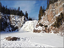
North Shore rivers aren't exactly quiet and serene in winter. We could hear the Onion noisily gurgling under our feet, and at the Baptism River's High Falls, water drummed against its cloak of ice like bongos.
You can see three waterfalls on the broad Baptism, and the Caribou is an easy jaunt with a waterfall of its own.
But our favorite snowshoeing river was the little Onion, just south of Lutsen.
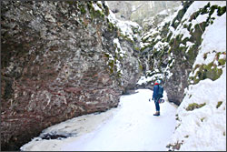
You can hop onto it from the Ray Berglund Wayside, and it feels like a secret, though it's not. Its route through narrow slot canyons is a favorite of locals, including Tofte photographer Tom Spence, whom we found in a round opening he called the "Onion theater" and "crying room."
"You can rarely get in here in summer; it's just too deep," he said. "Winter is the time to be here, that's for sure. I meant to go home half an hour ago, but I kept saying, 'Oh, what's around this corner?' "
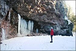
Ice and snow changes the scenery every day. In the theater, icefalls oozed down the pink rock, and tiny globes of ice hung across its wall like Christmas lights.

© Beth Gauper
Upstream, the gorge widened, and more snow had found its way onto the river. Gaping slits in its crust were lined with ice crystals, dainty as moth wings.
Our next stop was the Baptism River in Tettegouche State Park. From the trailhead parking lot, we made our way down to the river.
Being farther from shore, this time we paid close attention to where other people had walked, and we were surprised to see tracks going right up to High Falls.
Miniature volcanoes of tan foam were erupting from the base of the falls, and we could see bits of open water, so we admired it from a distance.
It was Super Bowl Sunday, and we had that beautiful bowl all to ourselves.
From High Falls, we walked downriver to Two Step Falls, hugging the banks just to be safe, and back to our car.
We tried another river in Beaver Bay. From the riverside rest stop, we walked up the Beaver River far enough to see a waterfall we didn't have time to scale.
We weren't done with ice. We had slushy cosmopolitans waiting for us at an ice bar at Grand Superior Lodge, just south of Gooseberry Falls State Park.
Under a tent, there were two rooms, one with the ice bar and one with animal skins over an ice bench and a fish sunk into ice over an ice fireplace near an ice sink and an ice faucet.
"People ask, 'What's the bar made of?' " the bartender told us with a smile. " 'Does the faucet work?' "
The next weekend, we snowshoed up Tischer Creek in Duluth's Congdon Park, one of our favorite hikes in every season. But we got lured off the creek when we noticed a freakishly large number of people traipsing up the east side of its banks.
Curious, we followed them and ended up looking at a boreal owl sleeping in a tree. The birders had come from all over the United States on a moment's notice, just to add the owl to their life lists.

© Beth Gauper
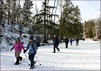
And once, we snowshoed up the Caribou River with a group. It was flat, scenic and had a big waterfall — perfect for beginners.
We have more river gorges we want to explore. Photographer Rudi Hargesheimer, a longtime board member of the Superior Hiking Trail Association, also recommends the Manitou, the Cascade and the Kadunce.
Along with Tischer Creek in Duluth, he likes Chester Creek, both "splendid little streams that equal those on the North Shore, and they're right in the city."
The Beaver River is one of Hargesheimer's favorites because both banks are private land, and traveling on the river itself is the only way to see it.
To cover more ground, he likes to ski down the rivers with friends, leaving one car at the beginning of the ski, up in the hills where there's plenty of snow, and one at the river's mouth.
They make a day of it. On the Baptism, they start near Finland, and on the Beaver, they start where Lax Lake Road/County Road 4 crosses the river.
But it's tricky to navigate waterfalls on skis. On snowshoes, he says, "anything goes."
Trip Tips: River canyons of Minnesota's North Shore
What to know: Snow insulates ice, so a thick snow cover is no guarantee of safety on a river. Go with a buddy, and look for tracks of other people.
If you're on snowshoes, you decrease your risk of breaking through ice. In winter, most North Shore rivers have only a foot or two of water, but you risk frostbite or even hypothermia if you get your feet wet far from your vehicle.
Avoid the bases of waterfalls, where water circulates in deep pools and keeps ice from forming.
What to bring: Snowshoes with crampons, poles and extra clothing, especially socks.
Good rivers to explore: The rivers below are especially scenic, shallow and easy to reach.
For more on trails and guided hikes with shuttle, see North Shore by snowshoe.

© Beth Gauper
Tischer Creek in Duluth. Park half a block up from Superior Street at 32nd Avenue East. The Congdon Park Trail follows Tischer Creek 1½ miles up the hillside.
The steep banks can be icy, so bring poles and ice crampons or cleats.
Beaver River at Mile 51 on the east edge of Beaver Bay. From County Road 4 just up from Minnesota 61, there's a parking lot from which you can walk to the river.
Baptism River at Mile 58.5 east of Silver Bay. From Minnesota 61, take the Tettegouche State Park road (vehicle permit required) up to the trailhead/campground parking lot.
Caribou River at Mile 71.3 between Little Marais and Schroeder. From the wayside parking lot, it's a flat and easy hike on the river to a waterfall.
Onion River at Mile 87 near Lutsen. Park at the Ray Berglund Wayside, less than half a mile west of the Sea Villas and the Cliff Dweller motel and 3.7 miles west of Lutsen Lodge.
Devil Track River at Mile 114, four miles east of Grand Marais. Take County Road 58 up from Minnesota 61, park at the Superior Hiking Trail lot and head west into the river gorge.
The walls of this gorge are very tall and steep, so be especially careful not to get in trouble.