Road trip: Southwest Minnesota
In the middle of the prairie, blood-red rock splits the sod, holding meaning far beyond the picturesque.
© Beth Gauper
In the southwest corner of the state, the prairie hardly looks like typical Minnesota vacation land.
Instead of lakes, fractured red quartzite erupts from the earth, and wind towers pop up on the horizon like giant black daisies. Herds of bison graze in fields, and yellow blooms cover prickly pear cactus.
This was the spiritual center of the universe for indigenous people on the prairie, and it exerts a pull on others, too.
Ancient stories are inscribed on outcroppings of quartzite at Jeffers Petroglyphs. At the quarries of Pipestone, seams of softer catlinite are carved into sacred pipes.
North of Luverne, the blood-red rock forms a 1½-mile long cliff called Blue Mounds by early settlers, who first glimpsed it in a far-off haze.
It's not lakes country — but it's just as beautiful.
From the Twin Cities, the route heads south along the river that gave Minnesota its name. Many people confuse the river's Dakota name with a beer slogan, and no doubt Minnesota should mean land of sky-blue waters.
Instead, it means cloud-tinted, or murky, waters. The river led us straight to New Ulm.
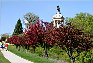
New Ulm: surrounded by 14,000 thirsty Germans
Our first stop in New Ulm is Schell's Brewery, which was founded in 1860 and thus is only two years younger than Minnesota itself.
It's a survivor in a state that once was full of breweries; now, it's even taken over the brewing of Minneapolis' once-mighty Grain Belt brand.
The Germans of New Ulm are devoted to their beer and to the family that has operated it for six generations. We toured the museum and Ratskeller, set on grounds that the late beer connoisseur Michael Jackson called "the most picturesque in America."
© Beth Gauper
We got lunch downtown, where the tourism office pipes oompah music onto Broadway Avenue, then headed west.
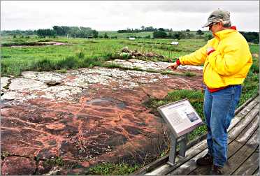
Jeffers Petroglyphs: stories in stone
In the middle of the prairie, a slab of quartzite is covered with stick figures — serpents, turtles, bison and thunderbirds with lightning bolts shooting from their eyes.
These are the Jeffers Petroglyphs, carved 5,000 years ago in stone that's among the hardest in the world. No one knows how they were etched — perhaps by the atlatl, a spear-throwing device — or what stories they tell.
But modern Plains Indians say this is a prayer place, and the carvings represent benevolent spirits.
The harsh midday sun makes the carvings hard to see, so we followed a guide who used a sheet of plywood to cast a shadow and a mirror to illuminate them.
© Beth Gauper
The handprints were easiest to pick out; some tribes say these are the places where spirits closed the rock after they emerged.
From the petroglyphs, we headed straight west to another prairie anomaly — a large lake. The water of Lake Shetek drew bison, then hunters, then a settlement of Europeans. Fifteen were killed there during the Dakota Conflict of 1862, and it was abandoned until the turn of the century.
Today, the eastern shoreline is Lake Shetek State Park, which includes a beach and campgrounds. A paved bicycle trail connects the park to Currie, looping around Smith Lake and returning along the Des Moines River.
From Currie, it's a straight shot west to Pipestone. Ahead, we could see the Prairie Coteau, the uplifted floor of an ancient sea whose red sand became solid quartzite.
During the last Ice Age, it split the advancing glacier, which dumped debris on its flanks and formed a ridge that rises more than 750 feet above the surrounding plain.
It's hard to plow, so local farmers are cultivating a new crop: the steady wind that blows over it, powering rows and rows of wind turbines.
Pipestone: sacred place on the prairie
Five miles east of the South Dakota border, quartzite suddenly erupts from the prairie, around a creek where flooding exposed a vein of red, hardened clay that's barely harder than a fingernail.
Plains Indians have mined this stone for centuries, carving it into effigies and pipes called calumets, whose smoke carried messages to the Great Spirit.
Artist George Catlin, the first European to see the quarry, recorded a Dakota account of its origin that Boston poet Henry Wadsworth Longfellow read and turned into "Song of Hiawatha," mixing Iroquois and Ojibwe legends with overblown Victorian romanticism.
© Beth Gauper
The poem was a hit and led to the founding of the town by an Iowa tourist who visited and decided to stay. C.H. Bennett was a romantic, and the poem brought him an equally romantic wife, a New Hampshire poet who wrote asking for a piece of pipestone.
They corresponded, married, then promoted Pipestone together.
For 60 years, townspeople put on a "Song of Hiawatha" pageant that brought thousands of tourists to Pipestone. That era ended in 2008, not because white men in red face were deemed inappropriate but because it was too much work.
The still-active quarries now are part of Pipestone National Monument, and in a corner of the visitors center, we were surprised to see slabs of quartzite bearing dozens of petroglyphs, including an odd little man with waving hands and a square hat.
They had been carved into quartzite around the Three Maidens, fragments of a 50-foot granite boulder that are considered the dwelling place of spirits who guard the quarries.
Afraid they would be defaced, Bennett took them away, but only half of the 36 stones have been found.
Here we could plainly see the petroglyphs and even touch them. We were like the Indians, missionary Stephen Riggs wrote in 1864, "looking upon them with feelings of mysterious awe."
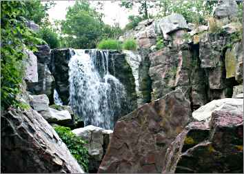
We walked the Circle Trail to Winnewissa Falls and watched carvers at work in the quarries and inside the visitors center. In the town, full of pink and red stone buildings, we admired the sandstone gargoyles on the 1896 Leon Moore Building.
On the grounds of the old Rock Island Depot, we went to a small powwow hosted by the local Keepers of the Sacred Tradition of Pipemakers.
"You're at the crossroads of the Indian world," said emcee Bud Johnston, who urged Europeans to join dancers in the circle. "People come to walk that quarry, and it grabs 'em; it really does."
© Beth Gauper
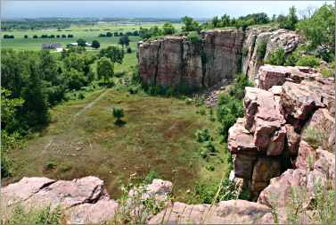
Blue Mounds: drama on a cliff
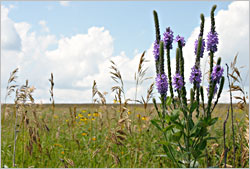
From Pipestone, we headed south to Blue Mounds State Park, which preserves a fragment of original tallgrass prairie on the roof of the Prairie Coteau.
From author Frederick Manfred's six-sided quartzite aerie, now the interpretive center, we walked along the Lower Cliffline Trail to the edge of a curving, sheer 90-foot cliff that forms a perfect backdrop.
For what, we didn't know. But it had significance to some people, who placed a 1,250-foot line of rocks between the Upper Cliffline and Upper Mound trails. On the first day of spring and the first day of fall, they align with the rising and setting sun.
The park is known for its prairie wildflowers, and clumps of blazing star, leadplant, purple prairie clover and Queen Anne's lace lined our path. We returned on the Mound Trail, where only a thin wire fence separated us from a bison herd that has grown to to about 100 from the original three, brought from Nebraska in 1961.
They kept their eyes on us — and we on them.

© Beth Gauper
From the park, the paved Blue Mound Trail winds six miles into Luverne, hometown of photographer Jim Brandenburg, whose gorgeous prairie images hang in a Main Street gallery. We stopped for twist cones at the Tasty Drive-In, got on the interstate, and headed home.
Road trip: Southwest Minnesota
The route: From the Twin Cities, take U.S. 169 south to St. Peter. From the south edge of town, take Minnesota 99 to Nicollet, then U.S. 14 into New Ulm.
Continue west on U.S. 14 and, seven miles west of Springfield, take U.S. 71 south to County Road 10. Go three miles east, then south on County Road 2 for one mile to Jeffers Petroglyphs.
From the Petroglyphs, go south on County Road 2 for three miles. Head west on Minnesota 30 to Currie and Lake Shetek State Park. Continue on 30 to Pipestone.
From Pipestone, head south on U.S. 75 to Blue Mounds State Park and Luverne. From Luverne, head east on I-90 to Albert Lea and return to the Twin Cities on I-35.
New Ulm: For details, see Where the Germans are.
Jeffers Petroglyphs: For details, see Written in stone.
Pipestone: For details, see Pipestone homage.
Blue Mounds State Park: For details, see Drama on the Prairie Coteau.
Good stops along I-90: In Fairmont, the Aquatic Park has four pools and two slides; turn south on Minnesota 15 and turn left on Johnson Street, at the southern edge of town.
This prairie town also has a chain of lakes on its western edge; there are swimming beaches on Lake Sisseton, in Ward Park, and on Budd and Hall lakes, from Gomsrud Park.
In Worthington, windsurfers frequent Sailboard Beach on the eastern edge of 785-acre Lake Okabena.
On the northwest side of the lake, there's a beach in Centennial Park and a municipal pool with water slide across from it. On the south side of the lake, there's a beach in Slater Park.