Waterfalls of northeast Wisconsin
Wild rivers and cascades reward those who explore the remote forests around Marinette.
© Travel Wisconsin
In a remote corner of Wisconsin, a trove of waterfalls lies buried in forests barely trod since the lumberjacks moved on to Minnesota.
They're not Wisconsin's largest waterfalls, or the easiest to find; those can be found on the lower lip of Lake Superior, in Pattison, Amnicon and Copper Falls state parks (see Waterfalls of northern Wisconsin).
But there are lots of them in this undomesticated forest, so thick with headwaters it's known as the cradle of rivers.
When the last glacier scraped through, it left a rocky landscape nicked by small lakes and veined by streams.
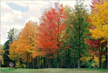
Today, it's Nicolet National Forest, 657,000 acres forsaken by the lumber barons, acquired by the federal government during the Depression, overgrown with hardwoods and now the domain of whitewater rafters, canoeists and fishermen.
It's not on the way to anywhere, so the people who find their way there know what they want: peace, natural beauty and not a lot of people. In Florence and Marinette counties, they also come for dozens of waterfalls.
On a beautiful day, they're excuse enough for a traipse in the woods.
One fall, I visited waterfall country, arriving via Iron Mountain, Mich., an iron-mining town of 8,500 whose heyday came in the 1880s. It's the biggest town in the area, and a tourist attraction in itself.
Trams take tourists into Iron Mountain Iron Mine, and there's a trail into Millie Mine Bat Cave, where a half-million bats, the second-largest gathering in the nation, can be seen arriving in late fall to spend the winter.
From Iron Mountain, I followed the Menominee River east to Piers Gorge. This is whitewater heaven for kayakers, and a half-dozen were practicing there, paddling downriver, then turning to do battle with the rapids.
© Beth Gauper
Children were scampering up and down the wide path on the Wisconsin side of the river, cushioned by cedar and pine needles. I walked 1½ miles upstream to the fourth pier, or step, then turned back and drove into Marinette County.
Marinette calls itself the Waterfalls Capital of Wisconsin. I started at Long Slide Falls, just south of Piers Gorge and the area's steepest falls at 50 feet.
There, the Pemebonwon River shoots over granite outcroppings in a narrow gorge, framed by the cedars and maples overhead.
It's easy to walk there from the parking area, but visitors have to use some fast footwork down sheer rock to get the best view.
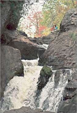
Smalley Falls is just up the road, at the end of a steep forest trail. Here, too, it helps to be as nimble as a mountain goat. I walked along a ledge next to the river, then onto a large, flat-topped rock in the river to get a good look at the cascade churning over black boulders.
But I had to work even harder to see Horseshoe Falls, on the Pike River southwest of Long Slide and Smalley. For two miles, I jounced along a little forest track lined with tree roots, finally adding my car to four others in a clearing.
Walking on, I heard a crashing sound, like rush hour in the forest, before rounding a bend to behold — a puny cascade, not enough to justify the abuse to my shocks.
Twelve Foot Falls, just north, was in the middle of civilization, at least for Marinette County. Part of the pleasant Twelve Foot Falls County Park, it tumbled tidily into a little bowl overlooked by picnic tables. I followed a trail to the top of the falls, looking down at a man fishing in the froth.
From northern Marinette, I drove up to Florence County.
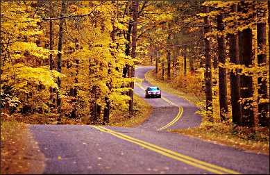
La Salle Falls, south of Florence, is the best known of its falls. There was another narrow dirt road to negotiate, followed by a pleasant trail through woods. Wind crashed overhead and yellow leaves twirled in the air.
Soon I heard a mumble and glimpsed whitewater. It was the falls, churning around and down a rocky chute into a frothy pool; I followed a trail at its edge to the flat granite where it began its descent into a gorge of the Pine River.
The Pine is one of three state-designated "wild rivers." The other in Nicolet National Forest (pronounced NICK-olay, after the French explorer who was the first to explore Wisconsin in 1734) is the Popple, nearby, and there I found my favorite waterfall.
© Beth Gauper
It wasn't the biggest, or tallest, but the walk was the prettiest on a fall day. Through a corridor of red maples I walked to Big Brule Falls, where I basked in the sun on slabs of black granite and watched the wide river hurtling over boulders.
Waterfalls are only one diversion on Nicolet National Forest's miles and miles of hiking trails. But once you've got the maps in hand, it's strictly do-it-yourself, because the forests of Florence and Marinette counties don't coddle newcomers.
The reward is splendid isolation, which, says Michelle Olson of the Florence Natural Resource Center, is what more and more people are looking for.
"We're one of the least populated counties in Wisconsin," Olson said. "But that just means there's more beauty to look at."
Trip Tips: Waterfalls of Wisconsin's Florence and Marinette counties
Finding the falls: Use Patrick Lisi's "Wisconsin Waterfalls: A Touring Guide" with a DeLorme Wisconsin Atlas & Gazetteer, in which detailed maps show waterfall locations.
Accommodations: Marinette has two grand bed-and-breakfast inns, M&M Victorian Inn and the Lauerman House Inn.
Twenty minutes west of Florence, the national forest service rents eight Lost Lake Cabins at Lost Lake Campground. The cabins sleep six in three bunk beds, and bathrooms and showers are in two central buildings.
They rent for $40 weekdays, $45 weekends, and they're open from mid-May to mid-October. Reserve at Recreation.Gov.
Dining: In Marinette, Micky Lu Bar-B-Q is renowned for its burgers.
Paddling: South of Florence off County Road N, the Pine River carves such an extreme oxbow that paddlers can glide for 3.5 miles, then walk back to their cars in 10 minutes.
Information: Wild Rivers Interpretive Center, 888-889-0049, and Marinette-Menominee tourism, 715-735-6681.