In the shadow of the Giant
In a provincial park wrapped by Lake Superior, campers exult in beauty.
© Beth Gauper
On the northwest corner of Lake Superior, a 1,000-foot-high sleeping giant stretches across the horizon.
It's mesmerized onlookers for millennia. In 2007, Canadian Broadcasting Corp. listeners voted it No. 1 of Seven Wonders of Canada, far outpolling Niagara Falls.
From Hillcrest Park in Thunder Bay, it looks exactly like a cigar-store Indian, with a square jaw and arms folded over a powerful chest.
From the city's Marina Park, wrapped in the glowing pinks and blues of sunset, it looks like a spirit — and Ojibwe legend says that it's Naniboujou, turned to stone.
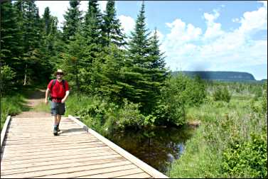
But to hikers on the tip of the 32-mile-long Sibley Peninsula, where the rock giant sleeps, he's a big Gulliver, there to be scaled.
On a trip in July, we planned to hike the Head Trail and Chest Trail first, then the Top of the Giant Trail overlooking the Knees. But epic humidity brought a wall of fog from the cold lake, and all the views from the giant's mesas disappeared.
So we turned to the attractions in the giant's shadow: a pristine inland lake with a big sand beach; a historic silver-mining village; trails to Lake Superior bays that were lined with wildflowers.
Sleeping Giant Provincial Park is a favorite destination of Thunder Bay residents, tourists on the Lake Superior Circle Tour and backpackers and campers.
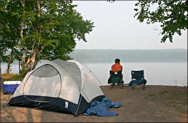
For a wilderness experience laced with luxury, there's nowhere else like it. For three nights, we camped on Marie Louise Lake on a secluded site that was much like those in the Boundary Waters Canoe Area.
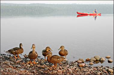
On the fourth night, we camped on a choice spot in the quiet campground, watching as beavers and duck broods swam by our own pebble beach.
© Beth Gauper
We ate camp food but treated ourselves to root-beer floats and blueberry pie with ice cream from the Silver Islet general store. We were camping, but it wasn't exactly roughing it.
Heading for the Giant
In summer, the road to the Sleeping Giant Provincial Park is lined by billowing clumps of ox-eye daisy, yellow bird's foot trefoil and purple bird vetch.
Even in July, the sun is up until 10 p.m., so we didn't hurry to our campsite on Lake Marie Louise Lake.
It was a four-mile drive on gravel roads from the main campground, and we had to bring in water, but we had our own wooded nook on the lake, with no sign of human habitation within sight.
As we unpacked, we met our neighbor Mike Moland, a board member of Friends of the Sleeping Giant.
"The park people act as if it's a punishment to camp here, but I think it's a reward," he said. "I go to Quetico a lot, and they're a lot like the campsites there."
The previous night, he'd heard wolves howling: "It was like listening in 3D, they were howling from so many locations," he said.
In the morning, the lake was like glass, but the birds were making a ruckus. A loon took off, sounding a loud rat-a-tat-tat as it slapped the water with its feet, and a merganser duck swam by with her brood, wheeling and turning like wind-up toys.
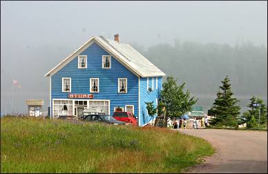
We had a swim, then drove to Silver Islet on the tip of the peninsula. The village was the jumping-off spot for the miners and engineers who, between 1868 and 1884, pulled $3.25 million in silver from a tiny rock dome a kilometer off the coast.
Tendrils of fog brushed our skin, and the temperature was 10 degrees cooler than the campground three miles away. Just across from the marina, we could see only the outline of Burnt Island, like a battleship with fir-tree masts.
© Torsten Muller
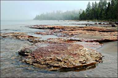
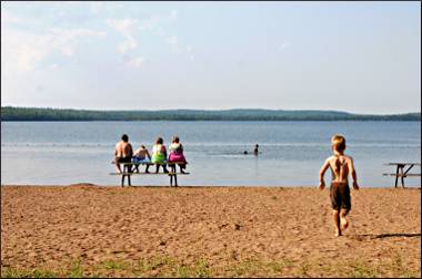
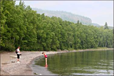
We couldn't see the point of climbing up the Giant only to see fog. Instead, we hiked to nearby Middlebrun Bay, passing several families with young children, some carrying body boards, who had spent the whole day there.
The curving sand beach was a beauty, with outcrops of red-and-white stone as scaly as a crocodile's back.
One of the park's unusually placid deer saw us and approached, then was distracted by a tasty plant. At the edge of the surf, old log timbers had been turned into a teeter-totter.
Isle Royale lay just 15 miles over the water, but we could barely see the ends of the bay.
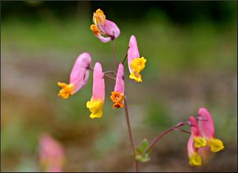
So we looked down instead, to the uncommon wildflowers along the trail, including white and pink pyrola and twinflower, the tiny blooms that Swedish botanist Carl Linnaeus named Linnaea borealis, for himself.
© Beth Gauper
A day of discoveries
The next day, we found hundreds of twinflower along the Kabeyun Trail, which follows the edge of the peninsula.
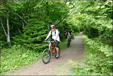
The 6½ kilometers to Tee Harbor were flat and relatively easy, but when we saw mountain bikers on the trail, we realized it would be easy to knock off the first eight kilometers by bike, reserving energy for the uphill climbs to the Giant.
"I feel stupid for walking," said my husband. "We could have ridden bikes and done 40K in a day."
We revised that thought when we saw the beautiful campsites along the sand beach, each in a roomy wooded grove with a fire pit.
It would be even better to backpack in and use Tee Harbor as a base camp, we decided, hiking up the Giant and also to the Thunder Cape Bird Observatory at the Giant's feet.
© Beth Gauper
The harbor, a Finnish fisherman's camp in the 1920s, is a destination in itself. Sitting on a log eating lunch, I realized that the pebbles at my feet were liberally salted with agates and quartz.
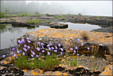
Walking farther along the T-shaped peninsula, we found a giant slab of volcanic rock, flat enough for 500 people to picnic on and covered with bright-orange lichen and the fattest, happiest harebells we'd ever seen.
There was a kiddie pool of rainwater and more wildflowers, including cinquefoil and peach and yellow corydalis.
We'd thought Tee Harbor was a great place to skip stones, but continuing along the Kabeyun Trail, we found Lehtinen's Bay, where every single stone, each as flat as a licorice pastille, was perfect for skipping.
On the bluff above, the fire pit of a campsite had been tiled in the larger stones, like a suburban patio.
© Beth Gauper
It was buggy, though, so we hightailed it back, stopping near the trailhead to walk along Perry Bay to the Sea Lion. It was shrouded in fog, but we could see the famous rock arch, whose head and mane fell away in the 1920s and now looks more like an anteater.
Pie and wildflowers
The next day, we hiked the Ravine Lake Trail loop from the Kabeyun Trailhead, and it turned out to be nonstop scenery, from a blufftop view of Grassy Lake to a rock-wall gallery and a serene lake dotted with the yellow flowers of bullhead lily.
On the boggy edge, I spotted purple marsh skullcap, and on the trail I saw the tiny one-flowered wintergreen, possibly the most exquisite wildflower of them all, with its plump star-shaped petals, scalloped edges and pale-green nozzle.
We could hear a foghorn booming, but this time when we got to Silver Islet, Burnt Island was visible from the deck of the old-fashioned tearoom, where we had slices of warm homemade pie and ice cream.
© Beth Gauper
The sun was bright and the air humid, but cool air wafted over our skin.
We spent the end of the afternoon swimming at the huge beach on Marie Louise Lake and our last night at one of the best campsites in Marie Louise Lake Campground, at the tip of the point.
Our neighbors were Keven Bender and Gareth Pritchard of Thunder Bay, who were there for two weeks and also spend every other weekend in the park and another week in August.
They'd brought mountain bikes and sea kayaks, and they also hike, hunt for mushrooms, bird watch and swim and fish right from their campsite. In the winter, they rent one of the cabins and ski.
"We'd like to see some other places, but it's just hard to leave this park," Bender said.
After just four days at the Sleeping Giant, we felt the same way. We're already planning our next trip. Orchid hunting in June? Thimbleberry picking in August? The views would be nice, too, but on this trip, I didn't really miss them.
© Beth Gauper
Trip Tips: Sleeping Giant Provincial Park
Getting there: It's 83 miles from Grand Marais, Minn., to Thunder Bay, then 26 miles to the turnoff to the Sibley Peninsula and 20 miles to the park office at the Lake Marie Louise Campground.
What to know: Eastern Standard Time starts at the Minnesota-Ontario border, so you'll lose an hour. Be sure to have a passport, passport card or enhanced driver's license, if you're from Minnesota, Michigan or other states that issue them.
If you're bringing a child not your own, you must have notarized permission from parents. If you're bringing a pet, you need vaccination records (pit-bull breeds are not allowed). For complete information, check the State Department Canada page.
You can use U.S. dollars if you like; most Canadian businesses accept them at a fair rate.
© Beth Gauper
What to bring: You'll want to bring everything you need; in Thunder Bay, you can stock up on food at the Safeway on the southwest corner of TransCanada Highway 11/17 and Red River Road. The park sells firewood and ice, and the Silver Islet General Store sells treats and staples.
If you want to cover the most mileage hiking, bring mountain bikes, which also are handy for getting around the campground and riding to Silver Islet. The Silver Islet general store also rents them.
Canoes and kayaks can be rented for use on Marie Louise Lake. If you want to kayak on Lake Superior, bring your own.
If you plan to swim from your campsite, bring water shoes so you can walk on rocks. The beach, however, is all sand and has a gradual drop-off, perfect for kids. There's no lifeguard.
Reserving a campsite: They can be reserved five months in advance at 888-668-7275 or online at Ontario Parks, which shows photos of each site. In the regular campground, the waterfront sites on the point — sites 138-141 and odd-numbered sites 143-167 — are most desirable and cost a little more. There are two very nice, clean shower houses.
© Beth Gauper
Sites 310-319 are right on the lake, but they're a four-mile drive from the campground on gravel roads — and because it's a one-way road, it's another seven miles back to the campground. There's no water source or showers, just two latrines.
Sites 310-313 are very private, but campers need to tote everything they need down a winding path; site 311 has the best view and lake access. Sites 314-319 are open to the road, but cars can pull right up to the sites.
Park activities: Naturalists give daily programs in the amphitheater. There's a visitor center with displays about the park flora, fauna, geology and history, plus a park store.
The Friends of the Sleeping Giant host special weekends, such as the Festival of the Giant in August, which includes a corn roast, sand-castle contest, games and a pancake breakfast.
On the first weekend of March, cross-country skiers come for the Sleeping Giant Loppet.
© Beth Gauper
Hiking: Bring mosquito repellent and hiking boots for walking on the rocky and root-choked trails.
You'll get only a rudimentary trail map with the visitor guide; the Friends of Sleeping Giant sell a much more useful map.
The marquee trails are to the Top of the Giant and Head of the Giant, both difficult. The Top of the Giant is 11 kilometers one-way from the Kabeyun South trailhead; you can expedite the first 8 kilometers on the Kabeyun Trail by riding it on a mountain bike.
The Head Trail is 7 kilometers one-way via the inland Sawbill Lake and Sawyer Bay trails or 8 kilometers one-way from the Kabeyun Trail junction on Lehtinen's Bay.
Backpacking sites line the trails. Some people camp in Tee Harbour or Lehtinen's Bay and make day hikes to the Knees, Chest and Head of the Giant.
Other fine trails include the 1.5-kilometer Ravine Lake Nature Trail loop and the trail to Middlebrun Bay on Lake Superior, where some families like to spend the day swimming and playing on the unusual red beach outcroppings.
The trail to Middlebrun Bay is about half the 4.2 kilometer one-way distance of the trail, which extends to Finlay Bay but isn't all that scenic. The map shows a campsite at Finlay Bay, but it was nearly nonexistent.
Cabins: Five three-bedroom cabins with modern kitchens and bathrooms on the lake in Marie Louise Campground are available from mid-September through mid-May. Reserve directly with the park.
Information: Sleeping Giant Provincial Park, 807-977-2526.