Dunes of Grand Marais
At the end of the road, this quirky beach town is the eastern gateway to Pictured Rocks National Lakeshore.

© Beth Gauper
The village of Grand Marais, Mich., feels as if it's at the end of the world, sitting in a front-row seat.
Beyond it lies Lake Superior, filling the horizon and plunging to its deepest point, 1,333 feet, not far away. Behind it is the vast wilderness of Lake Superior State Forest and the solitary road that cuts through it.
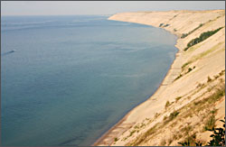
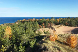
And on its western flank loom the Grand Sable Dunes, which would look impressively bleak if not for their wavy toupees of marras grass, beach pea and hoary yellow puccoon.
Amid all this drama sits a little village named by the French explorers, voyageurs and missionaries who passed through after 1658, pausing in its calm little harbor after the voyage along the "shipwreck coast" west of Sault Ste. Marie.
Grand Marais became a boom town in the middle 1800s, until the surrounding pine finally gave out in 1910. Fishermen made a living, but only until the whitefish fell to lamprey eel in the 1960s.
That left only beauty and an appealing end-of-the-road feel. For those reasons, Grand Marais today has a good bit of bustle for such a small place.
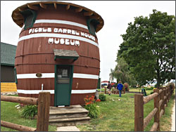
Summer residents have been finding their way to Grand Marais since the 1920s, an era from which the Pickle Barrel House, now an art gallery, is a relic.
Built in 1926 by a Chicago pickle manufacturer, it was a surprise for the creator of the Teenie Weenie cartoons, who drew the company's ads.
The cartoonist and his wife had to move out when their odd barrel cottage drew crowds of sightseers, but once introduced to Grand Marais, they came back for more than 40 years.

© Beth Gauper
Fishing has bounced back; when we were there one late June, fishermen in quilted overalls hovered on the big concrete pier like a flock of pelicans, watching the crashing waves for whitefish.
The wide, finely grained beach was like none we'd seen in the Midwest; watching the sun flicker on the tips of waving dune grass, picking up pieces of fossilized coral, we would've guessed we were at the ocean.
The big dunes are just west, at the edge of Pictured Rocks National Lakeshore.
At Grand Sable Lake, we struggled up a 300-foot dune — like climbing an escalator in reverse — to a narrow ridge at the top, where we gazed at miles of sand deposited by glaciers and sculpted by wind.
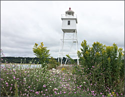
Five miles farther along H-58, the .4-mile Log Slide Trail leads to a platform with sweeping views of dunes and Au Sable Lighthouse to the west. It's tempting to run or roll down the dunes - but as some people have found, you may not be able to get back up.
From the Log Slide, the North Country National Scenic Trail follows the cliffs above Lake Superior for 37 spectacular miles to the park's western gateway, Munising.
Since Grand Marais is not as easy to reach, it's less-visited than Munising. Grand Marais also welcomes tourists, but as a North Country Trail Town, it's got a soft spot for backpackers and other outdoorsy types.
All of the marquee attractions are outdoors, though the excellent jukebox, taxidermy and beer at Lake Superior Brewing have many fans.
Sable Falls is on the edge of town, connected by beachside trail to the municipal Woodland Park campground, which has its own beach.
There's a swimming beach in the protected harbor, the first refuge for mariners heading west from Whitefish Point.

© Beth Gauper
And at the end of the day, everyone wants to be at Agate Beach, admiring the sunset over Lake Superior.
Trip Tips: Grand Marais, Michigan
Getting there: From Munising, it's 50 miles on winding County Road H-58, which now is paved.
Or take Michigan 28 straight east to Seney, then 77 straight north to Grand Marais, 60 miles.
Annual events: Fourth ofJuly weekend, Fourth of July Celebration. Early August, Grand Marais Music & Craft Festival. Mid-September, Classic Car Show.
Great Lakes Sea Kayak Symposium: This kayak festival in mid-July is the oldest on the Great Lakes and offers instruction, coaching, fun paddles and a kids' camp.
Pictured Rocks National Lakeshore: Grand Marais is the gateway to the attractions on the east side of the park. The 75-foot Sable Falls are a mile west of town on County Road H-58 and the Grand Sable Visitor Center and Grand Sable Dunes just beyond that.
The Log Slide is seven miles from town, and the 1874 Au Sable Lighthouse is 12 miles plus a 1½-mile walk on the North Country Trail.
For more about the Munising side of the park, see Michigan's Pictured Rocks.
Au Sable Lighthouse: Lighthouse tours are given Wednesdays-Sundays from mid-June through September, $5.
Volunteer keepers can spend up to a month in a one-bedroom apartment on the second floor of the 1910 head-keepers quarters.
Historical sites: The local historical society operates the 1908 Lightkeepers House Museum, the Old Post Office and the Pickle Barrel.
Accommodations: The Agate Cross B&B has three suites, one of them accessible.

© Beth Gauper
The Superior Hotel is an old-fashioned hotel known for its hospitality and value. Bathrooms are shared; a continental breakfast is included.
The Beach Park Motel has 13 rooms, all with a view of the bay. There are also quite a few vacation rentals.
Camping: Woodland Park is a municipal campground on the lakeshore that has shower and laundry facilities and is walking distance from downtown and also to Sable Falls via a trail along the beach. It's first-come, first-served.
In the national park, the Hurricane River Campground is 12 miles west on County Road H-58 and the Twelvemile Beach Campground is 16 miles. Reserve in advance.
Dining: Lake Superior Brewing Co. is a fun place for a burger and flight of beer. Eh! Burger serves burgers and breakfast all day.
Next to the Pickle Barrel, Grand Marais Tavern serves burgers, pizza and locally caught whitefish.
Information: Grand Marais tourism, 906-494-2447.