Bicycling in St. Paul and beyond
Minnesota's capital city has its own set of marquee trails on rivers and lakes.
© Beth Gauper
Minneapolis, having once been named Bicycling magazine's No. 1 best city for bicycling, is better known for bicycling than St. Paul.
As usual, St. Paul is overshadowed by its larger twin. But you'd never guess it from the throngs of bicyclists on the popular Gateway State Trail, on Summit Avenue through town and on the St. Paul Classic tour, started 12 years before the Minneapolis Bike Tour and the state's largest bike tour.
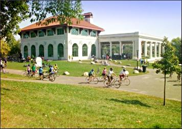
Like Minneapolis, the capital city has paved trails around lakes, past historic landmarks and along the Mississippi.
But it's only on the St. Paul side that bicyclists get to go by a giant snowman.
Every September, thousands of cyclists are introduced to these trails on the St. Paul Classic, which connects the river to parkways around lakes Phalen and Como and, on the short route, to the Victorian mansions of Summit Avenue.
Summit is the St. Paul equivalent of Minneapolis' Midtown Greenway, cutting west-east from the Mississippi to the Capitol and downtown.
It's got a wide bike lane and can be used to make loops with other trails, including the Big Rivers Regional Trail from Mendota, at the confluence of the Mississippi and Minnesota across from Fort Snelling.
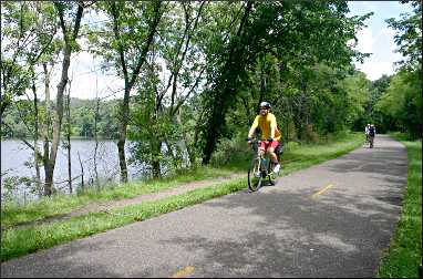
This 22-mile route starts at the state's oldest church, in the former fur-trade hub of Mendota, and heads along the side of the bluffs, lined with historical markers.
This could be the most scenic stretch of trail in the state; bicyclists heading north get great views of the river and downtown St. Paul before they descend to the shady woods of the Lilydale floodplain and pass the St. Paul Yacht Club.
You'll come out on Harriet Island, where St. Paul holds many of its festivals, including Irish Fair in August.
Cross the Wabasha Bridge and continue along the river or head west along Kellogg Boulevard, past the Science Museum of Minnesota, and up to Summit Avenue past the Cathedral of St. Paul and James J. Hill House.
It's hard to find a route anywhere in the state that passes as many historic sites. For details, see Twin Cities history ride.
But the most-used trail in Minnesota is the Gateway, which is strong on scenery.
© Beth Gauper
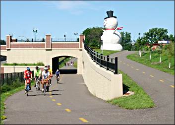
It starts north of downtown in the shadow of 35E, but people hop on at many places as it heads east, passing Phalen Park and the giant snowman in North St. Paul before heading into countryside near the Fleet Farm in Oakdale.
Then, it's all lakes, wetlands and winding trail through forest, occasionally alongside riders on horseback. The trail ends in Pine Point Park, easy striking distance of Square Lake and Marine on St. Croix.
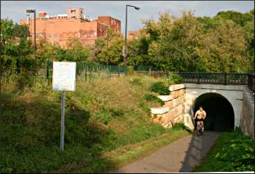
At the north end of Lake Phalen, the Gateway crosses the Bruce Vento Trail, which heads south to Swede Hollow and the nifty Bruce Vento Nature Sanctuary.
The other end of this six-mile trail is in downtown St. Paul, near Mears Park and the St. Paul Farmers Market. This is an industrial but historic part of St. Paul, and the nature sanctuary is a hidden gem.
It's a former rail yard and, before that, site of the 1853 North Star Brewery, eventually bought by Jacob Schmidt.
But the Dakota lived there first, and according to explorer Jonathan Carver in 1766, etched figures on the sandstone walls of the cave they called Wakan Tipi, or Spirit House.
Today, it's full of wildflowers. Six plaques explain the history.
From the sanctuary, the trail heads north to Swede Hollow, once full of shacks that were home to the immigrants who worked in Hamm's Brewery, which still looms over the park.
It continues through a light-industrial area before hitting Lake Phalen, whose west shore it follows on a pretty stretch lined by lots of wildflowers, willows and little bridges.
At Parkway Drive, it connects with the Gateway State Trail. You can use that to head east toward Stillwater or west toward Lake Como and Minneapolis.
Or, you can circle Round Lake in Phalen Park, then head back to downtown St. Paul on the east shore of Lake Phalen.
With so many rivers, parkways and off-road trails in the Twin Cities, everything's connected.
Trip Tips: Bicycling in and around St. Paul
Events: The St. Paul Classic bike tour, always on the Sunday after Labor Day, hits most of the highlights in the city and is on mostly traffic-free streets. It's a lot of fun, with live music and treats at frequent rest stops.
© Beth Gauper
The start and finish is at the University of St. Thomas, near Summit Avenue and the Mississippi River.
Gateway State Trail: This paved, 18-mile trail from St. Paul to Pine Point Park in Stillwater Township is very popular with in-line skaters, runners and walkers as well as bicyclists.
The western trailhead starts from Cayuga Avenue and I-35E (from the Pennsylvania Avenue exit just north of downtown, head .4 mile north).
The often-shady trail passes ponds, wetlands and Phalen Park. At Mile 7, bicyclists pass the giant snowman in North St. Paul (across from the high school, whose teams are the Polars).
Many people park at Mile 8.5 in the trail lot at the southeast corner of Hadley Avenue and Minnesota 36 in Oakdale. There's a porta-potty and water fountain.
From there, the trail heads north for nearly 10 miles of non-stop country scenery. At the end, Pine Point Park has bathrooms, water and picnic tables.
However, bicyclists also can head east to Stillwater on the paved, six-mile Brown's Creek State Trail. Built along the route of the old Minnesota Zephyr excursion train, it follows a trout stream and gently descends through wooded bluffs to the St. Croix River.
© Beth Gauper
For those who continue to Pine Point Park, it's only four miles to Washington County's Square Lake Park, which is one of the Twin Cities' best swimming lakes. Ride north on Norell Avenue, then east on Square Lake Trail.
Another popular destination is the St. Croix River village of Marine on St. Croix. From Square Lake, head north on St. Paul Avenue/County Road 7, then east on Nason Hill Road/County Road 7. Warning: The ride back starts with a very steep hill.
Bruce Vento Trail : You can latch onto this eight-mile trail, named for the late environmentalist congressman from St. Paul, at several points.
If you're riding along the river from other trails, you can start off Kellogg Boulevard at Broadway Street, two blocks southeast of Mears Park.
Turn right on Fifth Street, then right on John Street, and go under the Lafayette Bridge and along Fourth Street to the Bruce Vento Nature Sanctuary.
Or, start at Swede Hollow just off Payne Avenue and Seventh Street, where there's a parking area, and head north, turning toward Phalen Park at Johnson Parkway.
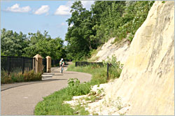
Big Rivers Regional Trail loop . This 4½-mile Dakota County trail starts in Mendota and follows the sandstone river bluffs, often with great views of the river and downtown St. Paul, before descending to the floodplain in Lilydale.
Paved trails continue to downtown St. Paul, and it's easy to make a 22-mile loop by crossing the river and taking the Samuel Morgan Regional Trail to the riverside trails in Crosby Farm Regional Park, Hidden Falls Regional Park and along Mississippi Boulevard.
Cross the Ford Parkway bridge to Minnehaha Park, take the Fort Snelling Trail to Fort Snelling and return to Mendota on the Mendota Bridge.
For details, see Twin Cities history ride.
Mississippi River Trail. The first signs of this developing 3,000-mile trail, also called U.S. Bicycle Route 45, have appeared around downtown St. Paul on previously unnamed stretches of bike trail.
For an 18-mile loop, park at the north end of Hidden Falls Regional Park in St. Paul, just north of the Highway 5 and Mississippi River Boulevard. Head south through that park and Crosby Farm to I-35.
Cross I-35 with the underpass. At Randolph, turn toward the river on the Samuel Morgan Regional Trail.
At Jackson Street, use city streets to cross the Wabasha Bridge or continue along the Lower Landing to watch the barge and tugboat traffic and return at the Childs turnoff (this adds three miles to the route).
© Bicycle Alliance
Across the Wabasha Bridge, continue on the Big Rivers route (see above). On the west end of the Mendota Bridge, ride between the officer quarters and fort to steps that lead to the Highway 5 bridge. Cross, turn left and ride to the north gate of Hidden Falls.
Getting to St. Paul trails from Minneapolis
For more, see Biking in Minneapolis and Bicycling west of Minneapolis.
The very popular 5½-mile Midtown Greenway, operated by a nonprofit coalition, cuts across south Minneapolis from Bde Maka Ska to the Mississippi River. It's paved and uses an above-street railroad trestle from the river through the Seward neighborhood, paralleling 27th Street.
At the river end, bicyclists can connect to St. Paul's parkways by heading either south to the Lake-Marshall Bridge or north to the Franklin Bridge.
To reach Summit Avenue, head south to the Lake-Marshall Bridge, cross and head south along the river parkway. To reach the Big Rivers Regional Trail, don't cross; keep going south to Minnehaha Park.
To reach the Gateway State Trail, ride north to the Franklin Bridge. Cross and follow 27th Avenue S.E. across University Avenue to 4th Street S.E., just east of the new University of Minnesota stadium.
Just to the north, the University of Minnesota Transitway for buses and bicycles makes for an easy ride to the State Fairgrounds. The first part now has been claimed by the Central Corridor light-rail line, but ride east on 4th Street and catch the transitway off 30th Avenue.
From there, it's an easy ride to Como Avenue.
Follow Como Avenue to the southeast corner of Lake Como. From there, it's a three-mile ride on Wheelock Parkway to connect with the Gateway State Trail, three blocks east of I-35 (this is not a trailhead; you'll have to carry bikes up a dirt path to the overpass).
Nearby state trails
Across the St. Croix River from Taylors Falls, Minn., 15 minutes north of Stillwater, the Gandy Dancer State Trail heads north from St. Croix Falls, Wis.
For more about St. Croix Falls and the Gandy Dancer trail, see Trail mix.
Just to the south, the new Stower Seven Lakes trail heads east from Dresser to Amery.
For more, see Savoring the Seven Lakes.