Bicycling through the Minneapolis suburbs
An expanding web of trails takes bicyclists from the city into the lake-filled countryside.
© Beth Gauper
For decades, the scenic bicycle trails around Minneapolis' Chain of Lakes have drawn people from the suburbs into the city. Now, it's the city folks' turn to visit.
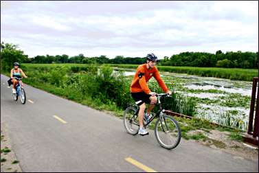
Hundreds of people daily ride the Dakota Rail Trail, which takes bicyclists past a chain of ponds, wetlands and bays on the north shore of Lake Minnetonka, through some of its toniest villages.
One of the newest trails connects the oldest trail. From the west border of Minneapolis, the Luce Line Regional Trail passes two swimming beaches and a sea of cattails on its way from Theodore Wirth Park to the Luce Line State Trail.
It's the last link in a 48-mile chain of five trails between the Mississippi River in south Minneapolis and the rural town of Winsted.
Bicyclists also can ride east from the Lake Minnetonka town of Excelsior, once the last stop on the Twin City Rapid Transit Co. streetcar line, to the easternmost stop on White Bear Lake, nearly to the St. Croix River.
On the way, they'll use five trails, a university transitway and city parkways.
Trails go right up to Fort Snelling, the Minneapolis Sculpture Garden, the Guthrie and Target Field, the Twins' new stadium. Most big festivals, such as the three arts fairs held in Minneapolis on the second weekend of August, are on or near trails, so bicyclists get a free pass around congestion.
People have caught on to the convenience; in 2010, Bicycling magazine first named Minneapolis America's Best Bike City, dethroning longtime champ Portland, Ore. (in 2012, Portland won the title back).
One day, a friend and I revisited the Luce Line, the first Twin Cities bike trail, and we found ourselves way out in Watertown. That state trail is remarkably rural and leafy, considering it starts in the second-ring suburb of Plymouth.
From my first ride in the early 1980s, I remembered many houses; this time, we barely saw any, no doubt because trees along the trail have had a long time to grow.
We did see a lot of sumac, which means the trail will show nice fall color from September, and we counted two raspberry-pickers.
On the west end, we saw egrets, herons and what looked like a black mink running across the trail; just east of Watertown, the Luce Line passes Oak Lake, so big that it had whitecaps on the day we rode by.
© Beth Gauper
The trail also is straight, flat as a pancake and protected from wind -the round-trip from Plymouth to Watertown was the easiest 38 miles I've ever ridden.
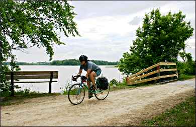
The new Luce Line Regional Trail, which connects the Plymouth trailhead to Wirth Park on the Minneapolis border, is a mixed bag.
It passes industrial plants and office parks, but it also crosses an ocean of cattails on two wooden bridges, dips into a shady woods and puts overheated bicyclists within half a mile of swimming beaches on Medicine and Parkers lakes.
In St. Paul, the Gateway State Trail starts in the shadow of Interstate 35 and immediately passes a small lake, unseen by any motorist. Even in the city, the trail is shady and quiet.
On the two-lane Cedar Lake Commuter Trail, the exit to the Minneapolis Sculpture Garden, on the edge of downtown Minneapolis, takes bicyclists past Spring Lake. Who's ever heard of Spring Lake, much less seen it? I have, now. It's lovely.
You can't see most of these places in a car, nor would most people choose to. But from a bicycle, they're a revelation-new and interesting things right in our front yard, but seen through the back door.
Trip Tips: Bicycling from Minneapolis to the suburbs
Maps : Three Rivers Parks District has done a fine job putting kiosks with maps along its routes in the western Minneapolis suburbs.
For a copy of its handy "Guide to Parks & Trails," call 763-559-9000 or pick one up at the Depot Coffeehouse in Hopkins, at the southeast corner of Excelsior Boulevard and Minnesota 169.
The Minnesota Bike Atlas ($19.95, Twin Cities Bicycling Club and Hostelling International), available at bike shops and bookstores, includes a CD of maps that can be printed out. Its tours use a combination of trails, streets and roads.
A Hudson's Twin Cities Street Atlas or similar map will help locate parking areas and ways to form loops.
Staying safe: Even on off-road trails, bicyclists need to wear helmets: You're much more likely to fall on your head by locking wheels with another bike or by stopping suddenly than you are to be hit by a car.
© Beth Gauper
Motorists, especially in cities, are increasingly likely to stop at bicycle crossings. But be watchful when a driver motions you to cross; other cars, obscured by the stopped car, may not stop.
Trail conditions : All of the trails are paved except for the Luce Line and the two LRT trails. Those have a surface of finely crushed limestone that is fine for touring bikes, although the dust tends to coat bicycle chains and bags.
Renting a bike : If you're visiting or don't have a bike, you can rent one by the hour or day from Nice Ride Minnesota kiosks in Minneapolis.
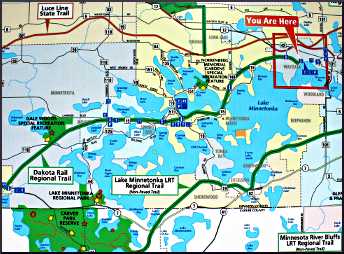
Trails in the western Minneapolis suburbs
Dakota Rail Regional Trail : This 25½-mile paved trail starts from the city beach in Wayzata and heads straight through the bays of Lake Minnetonka to the exurb of St. Bonifacius and on to rural Mayer.
For more, see Riding the Dakota Rail Trail.
Luce Line State Trail : This is the granddaddy of metro bike trails. Named for Col. William Luce and his son E. D. Luce, who founded the Electric Short Line Railroad Company in 1908, it starts in Plymouth and runs 45 miles west to Hutchinson.
© Beth Gauper
It's wonderfully leafy and rural, taking bicyclists over and under highways on bridges and culverts and passing many wetlands and lakes. The 19 miles from Plymouth to Watertown are straight and flat.
There's no source of water or food, though. In Watertown, Marketplace Foods has a nice selection of drinks and snacks. Luce Line Lodge Bar & Grill is across the street.
From Winsted, the 15 miles to Hutchinson are paved.
The trail can be reached in Plymouth from Parkers Lake Park, just west of I-494 off County Road 6, or by heading south on Vicksburg Lane to the trailhead parking lot (turn at the Cimarron Ponds sign).
From I-394/U.S. 12 in Wayzata, take Gleason Lake Drive north to Vicksburg Lane.
The state trail now is connected to Theodore Wirth Park and the Grand Rounds in Minneapolis by the paved, nine-mile Luce Line Regional Trail.
The eastern trailhead is just north of Minnesota 55/Olson Memorial Highway and Wirth Parkway, just south of the park's Par 3 Golf Course (park half a mile farther at the main golf course).
The trail twists and turns, so pay attention. After passing Golden Valley Golf and Country Club, turn instead of passing Calvary Lutheran Church. There's a fork after the Plymouth industrial/office park; turn left there (although there's a swimming beach on Medicine Lake .4 miles to the right) and also at the next unmarked fork.
Just before the regional trail connects to the state trail at Vicksburg Lane, it runs parallel to Parkers Lake, which has a swimming beach on the opposite side.
Lake Minnetonka LRT Regional Trail : Formerly known as the Southwest LRT northern corridor, this 15-mile trail goes through the town of Excelsior, which has many places to eat and shop (see Cruising around Excelsior ), and on to Victoria, with access to Carver Park Reserve.
The trailhead is in Hopkins on the west side of Eighth Avenue, just north of Main Street, not far from the Depot Coffeehouse.
Minnesota River Bluffs LRT Regional Trail : Formerly known as the Southwest LRT southern corridor, this trail heads 11½ miles to Chanhassen, descending to the Minnesota River valley through Minnetonka and Eden Prairie.
The trailhead is at the Depot Coffeehouse in Hopkins, at the southeast corner of Excelsior Boulevard and Minnesota 169.
The trails also connect to many regional trails in Three Rivers Park District. For a guide to parks and trails, call 763-559-9000.
Connecting trails from Minneapolis
The very popular 5½-mile Midtown Greenway, operated by a nonprofit coalition, cuts across south Minneapolis from the Mississippi River to Bde Maka Ska. It is paved and uses an above-street railroad trestle from the river through the Seward neighborhood, paralleling 27th Street.
© Beth Gauper
West of Hiawatha Avenue, it uses a below-street trench that parallels 29th Street. Bicyclists heading for the Metrodome and downtown can leave the Greenway at its bridge over Hiawatha and ride on a paved path along the light-rail train route.
On the Greenway, across from the Midtown Global Market at Chicago Avenue, the Freewheel Midtown Bike Center fixes and rents bicycles and also has showers, water and bathrooms.
The Greenway continues through Uptown and passes Bde Maka Ska, then connects with Three Rivers Park District's four-mile Cedar Lake Regional Trail and continues west to the Depot Coffeehouse in Hopkins and the LRT trails. However, the Cedar Lake trail is closed through 2021 for light-rail construction. A detour is marked with signs.
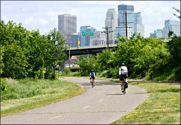
Also from the end of the Midtown Greenway, the 1½-mile Kenilworth Trail heads north toward downtown, where it runs into the city-owned 3.5-mile Cedar Lake Trail under I-394.
Downtown, the Cedar Lake Trail passes Target Field and connects to the Grand Rounds and Minneapolis riverfront at 3rd Avenue, across from Nicollet Island.
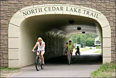
Heading west, it follows the north side of Cedar Lake and turns into Three Rivers Parks District's 4.3-mile North Cedar Lake Regional Trail, which continues to the Depot Coffeehouse in Hopkins and the LRT trails.
Bicyclists also can head in two other directions from trail junctions just south of downtown, adjoining the Kenwood neighborhood.
East to the Sculpture Garden From the Spring Lake exit of the Cedar Lake Trail, it's half a mile to the Minneapolis Sculpture Garden.
North to Wirth Park and the Luce Line : Next to the city demolition-debris yard, there's a spiral ramp to an overpass from which there's a two-mile, well-marked connecting route to the Luce Line Regional Trail in Wirth Park.
The signs stop at the Glenwood Avenue entry to the park; from Glenwood, turn north onto Theodore Wirth Parkway and watch for the trailhead just north of Highway 55.
The well-marked Grand Rounds National Scenic Byway (see below) also connects to Wirth Park, following the west side of Cedar Lake and coming from Bde Maka Ska via Dean Parkway, under the Midtown Greenway.
East to St. Paul trails
For more, see Bicycling in St. Paul and beyond.
Trails in Minneapolis
For more on riding the Grand Rounds, see Biking in Minneapolis.