Walking in Duluth
Trails along creeks, ravines and bays provide stellar hiking in the heart of town.

© Beth Gauper
A few steps into the forest, and it hit.
The tang of cedar bark and pine needles, moistened by droplets of mist from waterfalls. The loamy richness of earth carpeted by ferns.
It was that north-woods perfume all Minnesotans instantly recognize, a powerful eau de outdoors that gladdened my heart and also made it sink with the realization that I'd stayed in the city far, far too long.
Though in truth, I still was in a city. And that was the great thing.
Duluth is a big city, with 86,000 people and a waterfront lined with the grain terminals, ore docks and paper mills that go with its status as the Great Lakes' busiest shipping port.
The celebrated North Shore begins on the city's outskirts, at the Lester River, one of hundreds of creeks and rivers that plunge down the sides of a former glacial basin into what is now Lake Superior.
This is where most people go to get a fix of wilderness, losing themselves in the seven state parks farther up along the shore.
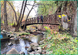
But Duluth itself has wild places in which the city recedes into the distance. The Congdon Park Trail is one of them, starting off Superior Street at 32nd Avenue East and following Tischer Creek 1½ miles up the hillside.
A block from rush-hour traffic, I was peering into a rocky gorge and picking raspberries.
Clambering past Norway pines on the red clay path, I passed one waterfall after another, coursing over sharp basalt boulders into a bed heaped with granite, as smooth and gray as an elephant's flank. A boy scurried past with a fishing rod and disappeared into the trees.
Mining and timber baron Chester Congdon gave this land to the city in 1908; his mansion, Glensheen, is downstream, and the trail bisects a neighborhood of hilly one-way streets and mansions that is as much fun to explore as the trail.
On the Park Point Trail, migrating shorebirds and songbirds are more common. This wonderful trail, four miles round-trip, has some of everything: the ruins of a lighthouse, a working lighthouse, quiet coves and a breakwall with views across the lake of far-off Duluth.
© Beth Gauper
The trail begins from the airport, over the Aerial Lift Bridge and at the end of the street that traverses this sand spit. A wide gravel track leads hikers into a quiet world, broken only by the sawing of crickets and the occasional grunt of cranes in Superior Harbor.
From a hushed thicket of red pine, the trail emerges into sand dunes — carpeted with poison ivy; watch out — and passes the remains of an 1855 lighthouse and an abandoned Coast Guard boathouse with stepped gables.
At the tip of the point, a lighthouse winks at the entry. In 1871, the city of Superior, Wis., tried to stop the dredging of the canal that now separates Park Point from the rest of Duluth.
It won in court, but Duluth citizens armed with picks and shovels finished the deed before a federal marshal could stop them.
Today, only 15 to 20 percent of harbor shipping arrives through Superior's natural entry.
The city's most visible trail starts on the other side of the Aerial Lift Bridge, where the paved, seven-mile Lakewalk follows Lake Superior from the Aerial Lift Bridge to Fitger's, Leif Erickson Park, the Rose Garden and beyond.
It's fun to walk, and the lakefront bustle gives it a festive air.
The trail continues past the Beacon Pointe condo resort at 21st Avenue (its construction right on the trail route remains a sore point to locals) and along the excursion-railroad tracks.
At 32nd Avenue, you can take a detour to walk the Congdon Park Trail (three blocks to the left) or visit Glensheen mansion (one block to the right).
The Lakewalk continues through the Congdon and Lakeside neighborhoods to Lester Park and back to the Lake Superior shoreline at Kitchi Gammi Park.
The nearly 1-mile Lester-Amity Trail follows the Lester River at the edge of town, off Superior Street and 61st Avenue East.
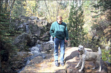
On the opposite side of town, another trail follows a lesser-known shoreline. The five-mile Waabizheshikana (waa-bah-zhay-kuh-nuh) Trail, formerly the Western Waterfront Trail, follows the St. Louis River estuary.
© Beth Gauper
From the trailhead across from the Lake Superior Zoo, at Grand Avenue and 72nd Avenue West, the shady trail skirts the foot of Spirit Mountain Ski Area, with views of river and cattail marshes that are prime waterfowl habitat.
Three other trails cross paths with the Superior Hiking Trail, which stretches from Jay Cooke State Park to Hawk Ridge and beyond, roughly following the same terraces used by Skyline Parkway.
For more, see Hiking in Duluth and Duluth's Skyline Parkway.
In West Duluth, the 3¾-mile Mission Creek Trail follows part of the old Skyline Boulevard in the Fond du Lac area of West Duluth, at 131st Avenue West.
Also in West Duluth, from the Lake Superior Zoo off Grand Avenue, the 1¼-mile Kingsbury Creek Trail winds along Kingsbury Creek. It's a spur of the Superior Hiking Trail.
In the heart of East Duluth, off Skyline Parkway, the 2½-mile Chester Park Trail has two sections. One goes through the park, which includes a playground and two ski jumps, and one goes down both sides of Chester Creek.
The trail down the west side of the creek, which includes small waterfalls, a cliff-lined gorge and swimming holes, is very scenic and a favorite spot of locals.
From the end of the trail at East Fourth Street, it's five blocks along 14th Avenue to the Rose Garden and Lakewalk.
For more information about trails in Duluth, call the Department of Parks and Recreation, 218-730-4300.
There's also a great hiking trail in Superior. The 5.3-mile Bear Creek/Makwa Ziibiins Miikana Trail on Wisconsin Point is a wide, winding trail that crosses dozens of small bridges on its way to the Lake Superior dunes.
To get there, cross the U.S. 53 bridge from Duluth, continue past Barkers Island, turn onto Moccasin Mike Road and immediately turn left, parking next to the small Bear Creek Park.