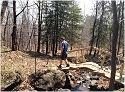
Hiking in Duluth
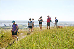
The city sections of the Superior Hiking Trail are easy to reach and amazingly scenic.
© Beth Gauper
To many people, it's still a revelation that Duluth is one of the best places to hike, not just in Minnesota but in the nation.
It's a city of 86,000, after all. But this hillside town, once called the San Francisco of the North, has spectacular terrain for trails, along glacial beach terraces high above Lake Superior and on creeks that tumble down rocky ravines.
Many hikers blow through Duluth on their way to sections of the Superior Hiking Trail farther up the North Shore. But the 43 miles that cross Duluth provide the most concentrated scenery on the entire trail, lake views and waterfalls included.
"We never thought we'd be able to put a trail like that through the city of Duluth, but we did," says Gayle Coyer of the Superior Hiking Trail Association. "Duluth is so amazing. In so many areas, you're going to think you're in a remote forest on the North Shore."
And in a city, hikers don't have the logistics problems of wilderness hikers: how to get back to the car and where to eat and drink.
Hikers can take buses to or from some trailheads; the fare is 75 cents on weekends and between 9 a.m. and 2:30 p.m. on weekdays (otherwise $1.50).
They can also leave bicycles at the end of their hikes, or hike one of three loops. And the trail goes by restaurants in West Duluth, East Duluth and on the Lakewalk.
Note: Before you go, check the Trail Conditions page of the Superior Hiking Trail Association website.
East Duluth, between downtown and the colleges
Perhaps the easiest hike in Duluth — which doesn't mean it doesn't have hills — also is our favorite. It's the 4½-mile stretch between Hartley Park, in the hills above the University of Minnesota-Duluth, and the Rose Garden above the Lakewalk.
It starts at Hartley Nature Center and, from Hartley Pond, winds through the park's vast woods.
From the other side of Hartley Park, it crosses Arrowhead Road to UMD's Bagley Nature Area and a balcony view of the city and lake.
From the campus (to stay in the woods, walk on the mountain-biking trail), it's all downhill to Chester Park, where you can admire the waterfalls of Chester Creek as it flows down a rocky, cliff-lined gorge to Fourth Street and Burrito Union.
On the restaurant's deck overlooking Lake Superior, we have lunch (and perhaps a beer from Fitger's Brewhouse), then walk the four blocks to the Rose Garden and toward Canal Park on the Lakewalk.
© Beth Gauper
West Duluth from Getchell and Highland
Possibly the most scenic stretch of the Superior Hiking Trail through Duluth starts at the junction of Skyline Parkway with Getchell and Highland avenues.
From here, it's 9.4 miles east to downtown, mostly downhill.
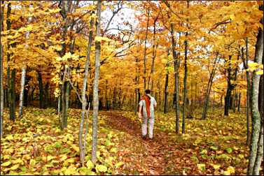
It's especially scenic in fall, because after the trail passes an old stone pump house on Keene Creek, it enters maple forest in Brewer Park. Then it emerges to an open ridge with panoramic views of the harbor.
On the section between Getchell and Haines Road, you can also hike the 3.4-mile Brewer Park Loop.
East of Haines Road, the hillier Piedmont section passes many knobs — rock faces protruding from the hillside— then arrives at Miller Creek and the N. 24th Avenue W. trailhead, just off Piedmont Avenue.
You don't even have to double back if you have two cars. For an excellent 6-mile loop hike that we call "The Greatest Hits," park your car at N. 26th Avenue W. and W. 3rd St., at the foot of Lincoln Park, and take the other car up Highland Avenue to the Getchell trailhead on Skyline Parkway and park. Near the end of the hike, after crossing Miller Creek in Lincoln Park, turn right instead of left and follow the creek trails straight down to your car.
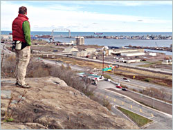
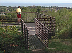
If you keep going on the Superior Hiking Trail from Lincoln Park, it's just a quarter mile up to the 24th Avenue West trailhead and then 1.7 miles to Enger Park, famous for its stone tower, flower gardens and replica of an ancient Japanese bell. The stone outcroppings on the park's edge have the city's best-loved view of Canal Park.
From Enger Park/Twin Ponds, it's a surprisingly scenic 2 miles to the Lakewalk. The trail descends the hillside through birch forest and overgrown Central Park, past elephantine knobs and to the edge of an old quarry.
There are harbor views there and from a rock clifftop studded with bolted steel anchors, where you'll be standing high above Michigan Street and I-35.
A pedestrian bridge over I-35 leads to a path between highway pillars and on to Bayfront Festival Park and past the Great Lakes Aquarium to Canal Park.
To do the hike with a bus shuttle, park at the Bayfront Park playground (free for two hours, except during an event), walk across the Fifth Avenue West bridge to Superior Street. In front of the Radisson Hotel, catch the No. 108 bus to the trailhead at North 24th Avenue West and Skyline Parkway.
If you'd like to walk the 8.8 miles between the Lake Superior Zoo and N. 24th Avenue W./Piedmont Avenue, you can use the No. 103 bus from the zoo on Grand Avenue to W. Third Street and N. 24th Avenue West, then the 108 up to the N. 24th Avenue W. trailhead.
Getchell/Highland to the zoo
Heading west from Getchell/Highland, it's a mostly downhill 3.2 miles to the Lake Superior Zoo.
© Beth Gauper
It's the most varied section of trail . On this stretch, the urban landscape adds to the mix.
The trail follows Keene Creek to a train bridge, where you'll tread on dusty red taconite pellets that have fallen out of the cars. Then it goes through alder forest to Westgate Boulevard, the Allyndale Motel and Cody Street.
After passing under the giant, graffiti-adorned pillars of I-35, it enters a sunny expanse of wildflowers, brush and table outcroppings with views of St. Louis Bay.
When you get to Kingsbury Creek, you may want to spend a little time clambering around on the smooth rocks upstream. Then, hike down to the zoo; we prefer the trail on the west side of the creek. At the zoo, there's an adjoining park with a playground and bathrooms.
Zoo to Spirit Mountain and Ely's Peak
Continuing west from the zoo, the ¾-mile spur trail climbs the cedar-lined west side of Kingsbury Creek, nearly to I-35, then heads two miles west through pine forest.
© Beth Gauper
It descends 138 wooden steps to Knowlton Creek, which it follows down to the Grand Avenue chalet at Spirit Mountain, a nice place to have lunch or a beer.
The return for this stretch would be easy by bike or even foot, since it's just one mile on Grand Avenue between the zoo and the chalet.
From the chalet, it's a two-mile climb to Magney-Snively Park. The trail crosses the banked mountain-bike trails of Spirit Mountain — watch out for speeding bikers — and passes the stone foundation of an old house and some knobs before emerging onto Skyline Parkway, a half-mile from the trailhead.
The stretch west of the Magney-Snively parking lot runs through an area that the Ojibwe consider sacred.
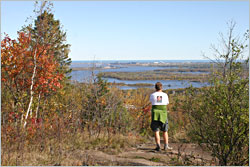
It's 1.9 miles to Bardon's Peak, or 3.8 miles out and back, through old-growth forest that's especially beautiful in fall. Bring a picnic and enjoy the views.
Continue another 1.5 miles (6.8 miles out and back) and you'll hike over a long expanse of rock on the way to Ely's Peak, which juts over the valley and gives you an even more spectacular view that includes the old U.S. Steel plant and town.
Stay long enough, and you'll likely see a train snaking toward you on the line below.
From Ely's Peak, it's a steep, rocky climb down to 123rd Avenue West and the paved Willard Munger State Trail, a total of 4.3 miles from Magney-Snively Park. This trailhead also is the best access to the three-mile Ely's Peak loop.
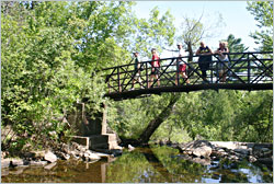
The 2.7 miles from 123rd Avenue West to 131st Avenue West in Fond du Lac also are beautiful, crossing Sargent Creek on a wood trestle bridge as it approaches the Mission Creek area.
The entire length of the trail is thoroughly marked, with blue blazes on trees, rocks, trailhead posts and, on city streets, stickers affixed to stop signs and telephone poles.
In the western section, hikers will marvel that trail scouts found such a perfect route, often high above ravines on little ridges that are just wide enough for a trail.
At the grand opening of the section from Jay Cooke State Park, I happened to be hiking just ahead of maintenance supervisor Mark VanHornweder, so I asked how he and other trailblazers picked a route.
© Beth Gauper
"It's easier if we wait until the leaves are down, and then we just kind of roam around," he said. "Sometimes, we're guided by maps; and sometimes, it's just dumb luck."
Loops
There's a 3.4-mile loop on the Brewer Park section between Getchell and Haines Road and a 3.5-mile loop on Spirit Mountain, most easily reached from the Grand Avenue Chalet.
There's a 1.7-mile loop around Ely's Peak, where you also can see the long cool tunnel of the former Duluth, Winnipeg and Pacific Railway. You can get there from the Beck's Road/123rd Avenue West trailhead, but it's easier to continue on Beck's Road to the Short Line Park parking area. From there, head right on the DWP trail to the loop and tunnel.
Shorter walks
As wonderful as the Superior Hiking Trail is, it's not the only great trail in Duluth.
The city has more than 50 miles of trail in other scenic spots, including the Waabizheshikana Trail, formerly Western Waterfront Trail, along St. Louis Bay; the sandy Park Point Trail from the airport to the Superior harbor entry; and Congdon Park Trail, up Tischer Creek from Superior Street.
For more, see Walking in Duluth.
The Lakewalk extends from Lester Park to Kitchi Gammi Park on the edge of town. It's seven miles between Canal Park and Kitchi Gammi's Brighton Beach, a favorite spot for picnicking and playing in the lake.
© Beth Gauper
Trip Tips: Superior Hiking Trail in Duluth
Before hiking, it's always smart to check for closures and trail conditions.
In winter, the hiking/running trails become snowshoeing trails, though so many people use them they quickly become packed.
Maps: Information on the Duluth segments of the Superior Hiking Trail is online, or pick up maps around town. The "Guide to the Superior Hiking Trail," $15.95, also includes maps of the Duluth sections.
Bus routes: Check the Duluth Transit Authority for schedules. Fares are 75 cents weekends and off-peak, $1.50 during commuting hours.
Shuttles: The SHTA offers occasional guided hikes at which leaders organize a shuttle.
The Willard Munger Inn, a hiker-friendly motel near the Kingsbury Creek/Lake Superior Zoo trailhead in West Duluth, provides shuttles to guests who want to go to any point on the Superior Hiking Trail within Duluth city limits (some parts of the trail between the inn and Jay Cooke State Park are in townships, however).
© Beth Gauper
The trailhead of the five-mile Waabizheshikana Trail is next door and across Grand Avenue from the zoo.
For more, see Duluth's other waterfront.
Camping: In West Duluth, through-hikers can camp right off the trail at Spirit Mountain and very close at Indian Point Campground, on the St. Louis River.
In East Duluth, there are six rustic sites at Bagley Campground in Bagley Nature Area on the University of Minnesota-Duluth campus. Four can be reserved; call 218-726-6134.
There's naturalist programming on weekends, such as canoeing, guided hikes and skills demos. Campers who don't have gear can rent a tent, stove, sleeping bags and cooking kit for $55 from the Rental Center, including the campsite. Without gear, it's $25 for up to two tents and six people.
From June through August, campers can park nearby and walk in. The rest of the year, the sites are open only to backpackers.
Bike shuttles: Many trailheads — Getchell/Highland, Enger Park, Chester Park — are on Skyline Parkway, a paved city street and also a state scenic byway. Just drop a bike at the end of your hike and ride back to your car when you're finished hiking.
What to bring: Water, snacks, sturdy boots and, in summer, insect repellent. In spring and early summer, be sure to wear long pants and watch for ticks.
Tourism information: For more about lodgings, dining and attractions, see Duluth 101 and other Duluth stories.