Walk 'n' roll
Thanks to the Gitchi-Gami, you can hike one-way on Minnesota's North Shore and bike back.
© Beth Gauper
Going hiking on the Superior Hiking Trail? You'll want to pack sturdy boots, thick socks, water bottles, maps and rain gear.
Oh, and don't forget the bikes.
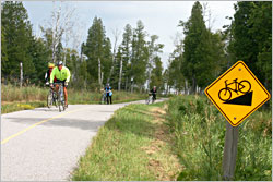
There's a bicycle trail on the North Shore, a nice flat one. It's the paved Gitchi-Gami State Trail, with a 17-mile stretch that links Gooseberry Falls to Split Rock State Park, Beaver Bay and Silver Bay, and a 12-mile stretch that links Schroeder to Temperance River State Park, Tofte and Lutsen.
Bicyclists and skaters love the trail, of course. But so do hikers up on the ridgeline — because if they stash bikes at the end of their hikes, they can spend the whole day hiking one way, then use the trail to get back to their cars in a flash.
It has always been possible for hikers to shuttle themselves by bike along the Superior Hiking Trail, and in some places, the shoulders on Minnesota 61 make it fairly safe.
But the Gitchi-Gami State Trail makes it safe and fun.
Hiking from Temperance
One August, my husband and I left our bikes at the Britton Peak Trailhead, 2½ miles up the Sawbill Trail from Tofte. Then, we drove to the Temperance River Wayside, left our car and started hiking up the east side of the river.
There were a lot of people along its narrow, rocky gorge, mostly watching two swimmers, a heavily tattooed man and a woman in a purple bikini.
The man was giving onlookers a thrill by jumping over waterfalls and into pools of dark water, not particularly smart considering the river was lower than we'd ever seen it.
"He climbed up here in his bare feet and jumped off, must've been 100 feet!" one watcher exclaimed as we passed.
As usual, people were hanging over the sides of the bridge above, gazing into the swirling river. As we looked up, we saw two bicyclists zooming by behind them, which surprised us until we realized the bridge is now part of the Gitchi-Gami.
© Beth Gauper
As soon as we left the river, we left the people. As famous as the Superior Hiking Trail has become, the vast majority of visitors don't venture beyond the scenic river gorges.
The maples already were changing color, and the trail was lined with fireweed and blue aster. Dry conditions had kept the insect population down, and hiking was as good as it gets. Even so, we passed only four other people on the way to Carlton Peak.
Suddenly, its smooth gray flank loomed ahead of us, heaved up from the Earth's crust a billion years ago.
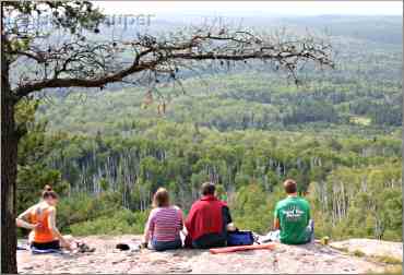
Once atop the 924-foot summit, it's hard to leave. There's a panoramic view of lake and inland forests, and the rock dome, warmed by the sun, is a good place to stretch out as lake breezes whip about overhead.
As we lounged amid the foundations of an old fire tower, a family of four climbed up and tried to launch kites into the Lake Superior breezes.
People seem to just materialize on Carlton Peak. When we finally left, there were 16 people atop the rock, yet we saw no one along the 1½ miles to Britton Peak.
Back by bike
The good thing about having a bike at Britton Peak is the fun has just begun. We hopped on and started flying downhill, at one point keeping pace with a deer we'd startled. Over 2½ miles, I had to pedal only a few times.
At the highway, we looked for the bike trail and finally asked at Bluefin Bay resort, where staff directed us through the resort, past the fire hall and onto Tofte Park Road.
That took us past tiny Tofte Park, which had a charming 1920s cobblestone fountain, bridge and sluiceway, and on to the little boat launch.
A nor'easter was picking up strength, and waves were pounding against its breakwall of basalt boulders, sending a wall of water at least 40 feet into the air.
At the end of the town road, we crossed the highway to the Gitchi-Gami, following it through forest and into Temperance River State Park.
Soon, we were the bicyclists zooming over the gorge bridge.
Trip Tips: North Shore hikes with bikes
To shuttle yourselves, simply leave bikes at the end of your hike and drive to where you want to start.

© Beth Gauper
On the 4.8-mile stretch of the Superior Hiking Trail between Temperance River State Park to Britton Peak and the Sawbill Trail (County Road 1), hikers can lock their bikes at the Britton Peak trailhead and start hiking from the Temperance River parking area on Minnesota 61.
After you reach Britton Peak, you'll have a 2½-mile downhill glide on the Sawbill Trail to Tofte, then a three-mile ride on the Gitchi-Gami State Trail.
There's a short gap between Tofte and the paved trail; ride through Bluefin Bay resort, follow Town Park Road and cross the highway to get to the trail.
Bicyclists can ride through Temperance River State Park, then take the first gravel road they see down to the highway, backtracking a short distance to their cars.
Tip: At the bottom of the Sawbill Trail, buy a picnic at the Coho Cafe and eat it in Tofte Town Park, along the lake.
Hikers also can use the Gitchi-Gami on other stretches of the Superior Hiking Trail:
The 5 miles between Gooseberry Falls State Park and the Split Rock River (it could work for an inline skate shuttle, too).
The 11.3 miles from the Split Rock Lighthouse State Park to County Road 4 (Lax Lake Road), which is paved and goes downhill into Beaver Bay.
© Beth Gauper
The 4.7 miles between Beaver Bay and Silver Bay.
In Duluth, hikers can use Skyline Parkway to return by bike (and also the city bus).
For more, see Hiking in Duluth.
Two other stretches of the Superior Hiking Trail lend themselves to a bicycle return on the shoulder of Minnesota 61:
The 9 miles from Castle Danger to Gooseberry Falls State Park.
The 5.1 miles from the Arrowhead Trail north of Hovland to Jackson Lake Road.
But not all sections of Minnesota 61 are safe for bicycling.
"It varies widely," says the Superior Hiking Trail's Gayle Coyer. "It goes from a dream shoulder to being barely a foot wide and really dangerous."
Bike rental: Sawtooth Outfitters, at the end of the Sawbill Trail in Tofte, rents road bikes, 218-663-7643. It also can do bike repairs.
Gitchi-Gami State Trail: The trail association hosts an annual ride in August. It uses the trail and also local roads.
More information
For more about the best hikes, see Hiking Minnesota's North Shore.
For accommodations, see Where to stay on Minnesota's North Shore.
For trail maps and information, contact the Superior Hiking Trail Association, 218-834-2700, or stop by its headquarters in downtown Two Harbors at 618 First Ave., open weekdays.