Hiking Minnesota's North Shore
Soak up the scenery above Lake Superior with one of these great day hikes.
© Beth Gauper
It took me nearly 20 years of hiking on the North Shore to tackle Eagle Mountain.
It's the highest point in Minnesota, but it's not exactly on the lakeshore; it's 14 miles inland, as the crow flies. I was used to tramping along the rocky river gorges whose horehound-tinted waters rivers boil furiously down to Lake Superior; I was used to drama.
But the 3½-mile hike up 2,301-foot Eagle Mountain was just as dramatic. The path, a root-choked corridor through cedars and spruce, soon enters the Boundary Waters Canoe Area Wilderness.
Passing through bogs, partly on boardwalks, it skirts mirrorlike Whale Lake, then picks its way through gantlets of rock up to the top.
There, hikers gaze upon a spectacular panorama that includes the North Fork of the Cascade River and Zoo, Shrike and Eagle lakes, set amid waves of greens and yellow.
The actual summit is obscured by bushes, but rock cairns point the way to a plaque and a box, which holds a notebook in which hikers register their impressions: "I've climbed Eagle Mountain; what's left?" wrote Jeff of Lakeville.
There's no such thing as a bad hike on the North Shore — or if there is, I haven't found it.
I started with ever-popular Oberg Mountain and then developed other favorites, such as the trails along the Upper Cascade and the Kadunce north of Grand Marais.
Usually, I hike in the state parks, but once I stopped at the nondescript Ray Bergland Wayside, on the hunch there might be a nice trail from there. And there was, a beauty that followed the Onion River to a waterfall.
Since then, the Superior Hiking Trail has incorporated many of my hikes into its 310-mile system, which starts in Jay Cooke State Park and follows a ridgeline above Lake Superior from Duluth to the Canadian border.
Cutting along the flank of the Sawtooth Mountains, at some points more than 1,000 feet above Lake Superior, it crosses dozens of creeks and rivers, many also lined with trails.
What to know
Before you go, check the Superior Trail Hiking Associations Trail Conditions page for closures.
In 2024, the popular Bean and Bear Lakes loop from Silver Bay will close May 15 for maintenance and the eastern side of the Split Rock River loop will close Sept. 1. Hikers will be able to bypass the closed sections.
When to go
Hiking can be good in early spring, when there are few people on the trail and the ground is still frozen.
In late spring, mud can be a problem, and ticks are thick in late May and early June. Disease-carrying deer ticks are not uncommon along the North Shore; for tips, see How to prevent Lyme disease.
© Beth Gauper
Hiking also is good in midsummer, because the heat keeps mosquitoes at bay during the day, the tree canopy keeps much of the trail shaded and hikers can take dips in the many swimming holes (use extreme caution around waterfalls and in rapids).
In late summer, water may run low in streams, so bring as much water as you need.
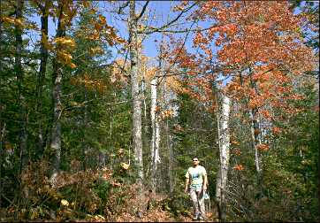
Fall is everyone's favorite time to hike. Most people try to hit peak fall color, generally the last week of September and first week of October. Late fall also is good; only mountain-ash berries provide color, but muddy trails harden and falling leaves open up new vistas.
Hiking still is good into November, when hotel rates drop. Just remember to wear blaze-orange or red.
The deer-hunting firearms season starts the first Saturday in November, and the Lake County part of the Superior Hiking Trail closes (Cook County, which is virtually all Superior National Forest, starts five miles east of Little Marais and continues to the Canadian border).
The grouse and bear seasons start in September and moose season in October, so it's a good idea to wear bright colors all fall.
Maps and information
The Superior National Forest ranger district offices in Tofte, 218-663-8060, and Grand Marais, 218-387-1750, give out a very handy list of hikes with a map.
For details on hunting and the Superior Hiking Trail, see the SHTA website.
The group's "Guide to the Superior Hiking Trail" (Ridgeline Press, $15.95) is very useful. People planning a trip can ask to join the group's Facebook page.
For the Duluth section of the Superior Hiking Trail, see Hiking in Duluth.
For places to stay, see [Where to stay on Minnesota's North Shore](/plan-a-trip/regions/north-shore/north-shore-lodgings/.
For help figuring out where the main attractions are, see North Shore by the mile.
The best day hikes
These are some of the most popular day hikes, listed from closest to farthest.
For more about backpacking on the North Shore, see Trekking the Superior Hiking Trail.
For more about winter hiking, see North Shore by snowshoe.
© Torsten Muller
Gooseberry Falls State Park
Few miss this picturesque park, which straddles the highway.
Eighteen miles of trails wind through the park, but most people will want to spend their time clambering around on the lumpy floes of ancient lava that hold up Upper and Lower Falls, and down to the river's mouth on Lake Superior.
Mile marker 39.5 (from Canal Park in Duluth).
Split Rock River loop
This five-mile loop starts four miles north of Gooseberry, at the mouth of the Split Rock River; there's a parking area. You'll hike up the west side of the red-rock gorge and cross on a bridge (you may see pilings and think the bridge is out, but it's a little farther up).
On the east side, the trail veers away from the river to avoid the marshy mouth, but there are gorgeous views of Lake Superior from an open ridge.
The trail then returns hikers to the highway, which they must cross and walk along a block of paved Gitchi-Gami Trail to a culvert and the parking lot.
Mile marker 43.5.
© Beth Gauper
Silver Bay to Minnesota 1
This 11-mile section of the Superior Hiking Trail is one of the most scenic and most challenging, winding past Bean and Bear Lakes in Tettegouche State Park, then past Round Mountain and Mount Trudee, with great views of Lake Superior, then High Falls on the Baptism River.
Mile markers 54.3 (Silver Bay; turn left at Outer Drive and go 1.5 miles to Penn Boulevard/County Road 5, then another half mile and park in lot on right) and 59.3 (Minnesota 1; from there, go 0.8 miles and park in lot on left).
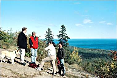
Tettegouche State Park
From the park office, a trail follows the Baptism River and merges with the Superior Hiking Trail. At High Falls, the tallest waterfall completely within Minnesota, it crosses a suspension bridge, heads back and crosses again at Two Steps Falls.
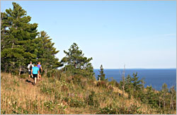
And don't miss the half-mile trail to Shovel Point, where basalt headlands form a coastline that looks more like northern California than Minnesota. The view, which includes Palisade Head to the south, is incomparable.
Mile marker 58.5.
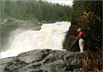
Temperance River State Park
Trails at this park, named because the river has no bar at its mouth, follow the tortuous course of the Temperance River, seething and twisting like a flume ride from hell. Pebbles in the swirling water have scraped potholes in the riverbed and in the sides of the gorge.
Mile marker 80.4.
© Beth Gauper
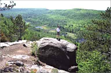
Carlton Peak
This massive pile of volcanic rock, whose 924-foot summit commands a spectacular view up and down the shore, is three miles north of Temperance via the Superior Hiking Trail.
The other way to reach it is by driving three miles up the Sawbill Trail (County Road 2) from Tofte to the parking lot at Britton Peak; from there, it's three miles round-trip.
Mile marker 83.4 (to the Sawbill Trail).
Oberg Mountain
This two-mile hike probably is the most popular on the shore, especially in spring, when it's lined with wildflowers, and fall, when its many overlooks provide views of the mountain's inland maple forest.
East of Tofte, take Forest Road 336, or Onion River Road, two miles to a parking area.
Cross the road to the trail; after a short distance, turn onto the 1.8-mile Oberg loop, which winds around the summit.
From the other side of the parking area, the Superior Hiking Trail leads to Leveaux Mountain. It's a mile to a spur trail that goes to the summit.
Mile marker 87.
© Beth Gauper
Lutsen Mountains east to the Caribou Trail
This popular stretch from the ski hill in Lutsen cuts through maple forest, passing lovely Lake Agnes on its way to County Road 4, also known as the Caribou Trail.
Mile marker 90.
Cascade River
The trails that hug both sides of the river in Cascade River State Park are popular with everyone, especially children. If they're surefooted, they can jump from boulder to boulder and watch the river crash down to the lake.
Don't miss the Upper Cascade, where the trail is lined with old cedars and feathery ferns and hikers can sit on the shore watching the river tumble over a series of small falls.
It's a challenging but very beautiful eight-mile round-trip up the river to the County Road 45 bridge and back down.
Mile marker 99.8.
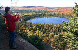
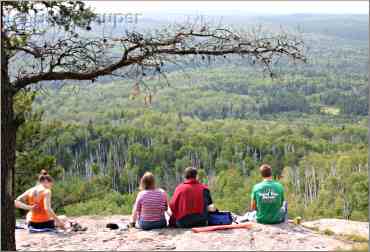
Eagle Mountain
The trailhead can be reached from Grand Marais by taking County Road 7 to Forest Road 48, then 158 to its junction with 153.
It's a little simpler to take the Caribou Trail, or County Road 4, from Lutsen to Forest Road 153; from there, it's about four miles east to the trailhead. Fill out free a Boundary Waters day permit and put it in the box before hiking.
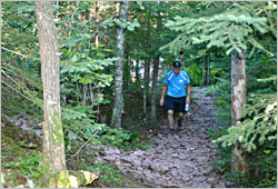
It's a difficult hike. The trail is clogged with rocks and tree roots, so wear thick-soled shoes or boots. It's seven miles round-trip; allow three to four hours for the hike itself and, until first frost, bring insect repellent.
Mile marker 110 for Grand Marais, 92 for the Caribou Trail.
Devil Track River
On the rim of this deep, narrow canyon is a 2.4-mile stretch of the Superior Hiking Trail, with views of the red cliffs and waterfalls below.
To get there, drive five miles north of Grand Marais to County Road 58 and turn; there's a parking area on the left.
Mile marker 114.
© Beth Gauper
Kadunce River
From a wayside 10 miles north of Grand Marais, a trail follows the rust-tinted waters of the Kadunce through its narrow gorge.
It's a spectacular and intimate little hike, 1½ miles round-trip, and the cobblestone beach opposite the wayside is one of the shore's prettiest.
Mile marker 118.7.
Judge C.R. Magney State Park
Trails in this park, named after the judge who proclaimed, "Our state parks are everyman's country estate," follow the Brule River past three waterfalls: the Lower, the Upper and Devil's Kettle.
At the Devil's Kettle, the river splits, half cascading 50 feet into a pool and the other disappearing into a pothole; no one knows exactly where it ends up. It's 2½ miles round-trip.
Mile marker 123.8.
© Beth Gauper
Grand Portage State Park
The Pigeon River, which marks the international border, is the largest on the North Shore and was the bane of voyageurs.
Its lower 20 miles, a series of cataracts and chasms, is unnavigable, so the paddlers had to make an 8½-mile uphill portage to its upper waters.
Today, visitors can follow a half-mile, handicapped-accessible trail to the state's tallest waterfall, gorgeous High Falls, cascading 120 feet over a sheer basalt wall. The Middle Falls Trail goes farther, over ridge tops, about three miles.
Mile marker 150.
Trip Tips: Hiking Minnesota's North Shore
What to know: Allow an hour for each 1½ miles. Bring water and snacks and be prepared for sudden weather changes.
For more about preparing for a hike, see Don't be a dope in the woods.
Superior Hiking Trail Association : This non-profit volunteer group maintains the route. The headquarters in Two Harbors, at 618 1st Ave., sells memberships and gives out information.
Stop by or call 218-834-2700.
Shuttles: Superior Shuttle offers shuttles from May through October, 218-834-5511. It will also take bicycles.
Arrowhead Transit buses offers limited service between Grand Marais to Duluth and back. There are also stops in Silver Bay and Two Harbors.
At many points on the Superior Hiking Trail, hikers can shuttle themselves by stashing their bikes at the end of a hike, then returning to their starting point by riding on the Gitchi Gami Trail.
For details, see Walk 'n' roll.
Camping: There are 93 primitive campsites along the Superior Hiking Trail. Hikers who arrive first must share with later arrivals.
They have latrines and fire pits, but drinking water must be taken from streams or lakes and purified.