Tracing the Ice Age Trail
In north-central Wisconsin, a slow-moving monolith left a playground for weekend wanderers.
© Beth Gauper
When the last glacier melted out of Wisconsin, it left a gift to future generations.
It wasn't much at first — boulders, heaps of gravel, water, chunks of ice trapped under rubble.
But over time, the ice seeped away and created kettle lakes for fishermen. The raging meltwater stripped away softer rock, leaving walls of volcanic rock for climbers and scenic river gorges for canoeists.
The heaps of gravel grew skins of greenery and, with boulders carried down from Canada, created a dramatic landscape.
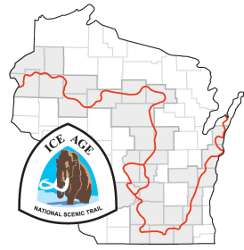
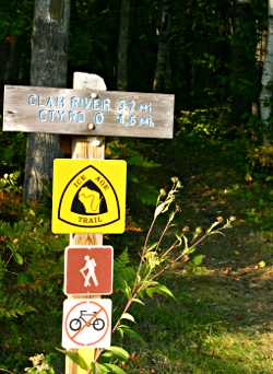
For hikers, they show the glacier's path as surely as cairns. The line along which the glacier retreated, tossing off rubble in fits and starts, now is the 1,100-mile Ice Age National Scenic Trail, one of nine nationwide.
From the Dalles of the St. Croix, it winds east through the eskers of Chequamegon National Forest and loops down to the Wisconsin Dells, east through the Kettle Moraine and up to Door County.
Its segments include a virtual Greatest Hits of hiking trails: the Pothole Trail in Interstate State Park, the Blue Hills near Rice Lake, the East Bluff Trail in Devil's Lake State Park.
(For more, see Greatest hits of the Ice Age.)
If it's scenic, it's probably glacial: Though the last glacier covered two-thirds of North America, it's called the Wisconsin Glacier because Wisconsin is where it left the most evidence of its passage.
You can get in a solid weekend's worth of hiking in almost any part of the state. But one of the areas with the most continuous miles of trails is in the middle of the state, where the Ice Age Trail hits its northernmost points.
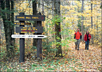
Hiking around Timm's Hill
One October, I hiked four of those segments, one in the Chippewa Moraine, near Bloomer, and three in Taylor County, through Chequamegon National Forest.
This section of the state is unsung — no large towns, no big tourist attractions. What it does have are quiet forests and lots of trails, lovingly maintained by the locals.
© Beth Gauper
This makes it a great place to be in fall, when piles of leaves swish under the feet of hikers and winding country lanes provide scenic routes for leaf peepers.
My base was at the foot of Timm's Hill, the highest point in Wisconsin and gateway to a forest full of trails. The 10-mile Timm's Hill National Trail starts there, a stone's throw from High Point Village resort; I hiked it once, and it was a beauty.
For more, see Trek to Timm's Hill.
This time, I took my husband and teens to the trail's southern trailhead, where we picked up the Rib Lake segment of the Ice Age Trail. The area also has many nordic-skiing loops, and junctions looked like those in Germany's Black Forest, marked with red, yellow, green and blue blazes.
Here, the trail pays tribute to the German Volksmarsch (people's walks) tradition; we passed the Brandenburger Tor and Stille Nacht campground on our way to the Ansiedlerdenkmalwald, or settlers' memorial forest.
So it gave us a start then we came to Old Tote Road, Tote being the German word for dead people. The road was used to supply logging camps, and the ruins of Camp 6 were along our path, as well as the site of a tannery that used the local hemlocks, extracting tannic acid from their bark.
There's a grove of baby hemlocks along the trail now, and we walked through stands of oak, maple and Norway pine, mixed with aspen and birch. A thick layer of leaves covered the rolling trail, and here and there a buttercup pushed through.
Wisconsin's Rustic Road 1 is just north of the trailhead, so after our hike we went on a gorgeous fall drive, winding around South Harper Lake, through Rib Lake and onto rolling Wisconsin 102.
That skirts Spirit Lake under a canopy of trees and leads to County Road C and Rustic Road 62, which returned us to High Point Village.
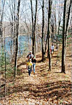
Then we left the kids in the cabin with a movie and headed for the eastern Wood Lake segment of the Ice Age Trail, deep in the forest.
We were enchanted by four tiers of gold — an ankle-deep layer of leaves, shoulder-high oak and maple saplings, a maple understory and towering oaks still holding onto a moptop of russet leaves.
Ferns were still June-green, and backlit maple leaves glowed purple. Gigantic erratics — boulders carried in by glaciers — popped up here and there, out of place among the trees.
© Beth Gauper
On to Mondeaux Flowage
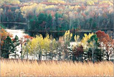
In the morning, we climbed the tower on Timm's Hill, for a view from the top of Wisconsin. Then we headed west to the sinuous Mondeaux Flowage, where a huge esker formed from sand and gravel deposited by a river flowing beneath the glacier.
After remote Wood Lake, the Mondeaux recreation area, which has four campgrounds, a swimming beach and boat rentals, seemed cheerful and civilized.
We bought twist cones at the pretty log Mondeaux Dam Lodge and walked high above a picturesque backwater on the 1.2-mile Aldo Leopold Commemorative Trail, lined with quotes from the Wisconsin environmentalist.
From a stand of red pine on the western shore of the lake, we followed the Ice Age Trail atop the esker, down to the West Point campground. It was a sunny Sunday, and families of hikers were out in force.
From Taylor County we drove straight west on County Road D through a lumpy landscape of glacial till, its grass toupee barely enough for a grazing cow.
At a bend in the Chippewa River, we turned south on Rustic Road 6, part of the Old Flambeau Trail, then west on County Road M through the Chippewa Moraine Ice Age National Scientific Reserve.
A center for the Ice Age
An interpretive center sits high on a pile of silted clay, once the bottom of a glacial lake.
It had just closed, but we stood looking over the treetops to the south, reading plaques that explained how a 600-foot-high sheet of melting ice had moved just to the horizon, where a massive chunk broke off and was buried by debris from the moving ice behind it.
When the buried ice melted, much later, it created the Chippewa Moraine.
The woods behind the center were still full of hikers, enjoying the last rays of sunlight. We headed onto the wide Woolly Mammoth Nature Trail, in a bowl sprinkled with kettle lakes, their still waters reflecting the crowns of oaks.
The Ice Age Trail balloons into a 4½-mile loop around the center, then extends a mile farther west. It picks up again in the Blue Hills, then skips over to Haugen, seven miles north of Rice Lake.
From there, the trail stretches 88 miles to the Ice Age Interpretive Center in Interstate State Park, the longest developed stretch so far.
© Beth Gauper
More than 620 miles of the trail are now complete, though 130 miles of those are on private land and 120 on county land.
Fortunately, the trail has many friends. The state's congressional delegation has secured millions for land acquisition, and volunteer members of 24 Ice Age chapters maintain the trail.
One day, said Christine Thisted of the Ice Age Trail Alliance, the trail will be like the Appalachian Trail, only better.
"It's close to where people live, it's in people's back yards," she says. "You don't have to drive 1,000 miles to access it. It's beautiful, and it's culturally significant — the land grew up and developed around its features."
And in Wisconsin, glaciers are considered cool.
"When I took this job, I thought, glacial features, who's going to know what that is?" Thisted said. "But people knew what they had, and they take great pride in it."
Trip Tips: Ice Age Trail in Taylor County
© Beth Gauper
Getting there: Timm's Hill is six miles east of Ogema, which is 20 miles north of Medford.
When to go: Usually, there's nice fall color through the third week of October. In the winter, there's excellent cross-country skiing. Glacial features are easiest to see in spring, before leaves come out.
Hiking tip: If you want to cover as much trail as possible, without having to repeat your tracks, plan a trip with friends.
Drop one group at one end of the trail, and then head for the other. Give your friends the car keys when you meet them on the trail and have them pick you up when they're finished.
Accommodations: High Point Village, across Bass Lake from Timm's Hill, rents four very attractive chalet cabins with loft, VCR and full kitchen.
There's a cafe on the premises that sells pastries, soup and panini. The helpful owners, Lyle and Kathy Blomberg, are active in trail development.
Camping: Mondeaux Dam Recreation Area has nice U.S. Forest Service campgrounds, with showers, boat rentals, a camp store and the historic Mondeaux Dam Lodge. Reserve sites at Spearhead Point, Picnic Point and Eastwood through Recreation.Gov, 877-444-6777.
Nature hike: The Gerstberger Pines Nature Trail through old-growth forest is two miles east of Rib Lake, south of Fawn Avenue off County Road C.
Nearby attractions: The Wisconsin Concrete Park folk-art sculpture garden is 18 miles north of Ogema on Wisconsin 13.
Information: Taylor County tourism, 715-748-4729.
Trip Tips: Ice Age National Scenic Trail in Wisconsin
Getting there: The western trailhead is in Interstate State Park, an hour west of the Twin Cities, and the eastern trailhead is in Potawatomi State Park in Sturgeon Bay on Lake Michigan.
The trail is about 1,200, but only 620 miles of trail are completed, connected mostly by country roads.
For more about Interstate State Park and St. Croix Falls, see Trail mix in St. Croix Falls.
For highlights, see Greatest hits of the Ice Age.
Ice Age Interpretive Center: It's seven miles east of New Auburn on County Road M.
On the first Saturday morning of October, the local chapter holds a Parade of Colors Fall Hike from the center. You'll pass 21 lakes on the six-mile trek, and be rewarded with refreshments at the end. Volunteers shuttle hikers to the starting point.
Maps: They're available from county tourism offices or the Ice Age Trail Alliance.
Hiking: Some segments are remote. Always carry water, food, a map, a poncho and a headlamp.