Greatest hits of the Ice Age
In Wisconsin, the best walking trails are gifts from the glaciers.
© Beth Gauper
If you've ever walked in Wisconsin, chances are you've walked on the edge of a glacier.
The ice is gone, but not the rubble it pushed across the landscape, or the rock its melting waters carved. As the last glacier retreated, it left a path that geologists can follow as easily as yellow lines on a highway.
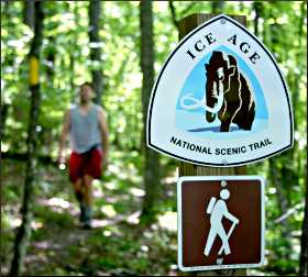
That path now is the 1,100-mile Ice Age National Scenic Trail, with 620 miles marked, usually by yellow rectangles tacked to trees. It's easy to follow in the forest, but many of the most spectacular spots are right along highways.
One fall, I kept running into the trail wherever I went. In late September, we got off Wisconsin 29 to explore the marble-like Dells of the Eau Claire near Wausau.
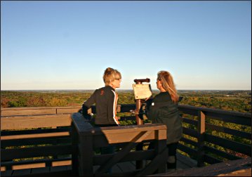
On the way home, we took in the view from Rib Mountain, which was known as Wisconsin's highest point until Timm's Hill, also a stop on the Ice Age Trail, took the title.
In early October, I hiked along the Dalles of the St. Croix River, where swirling rubble drilled the world's largest potholes.
In mid-October, we spent half an hour photographing a lovely marsh where the trail crosses the Wisconsin River between Merrill and Tomahawk, and we followed the trail home along U.S. 8, stopping to hike in the Blue Hills.
You can't help loving this trail. It's best hiked in spring, before trees leaf out, and in autumn, when fallen leaves open up the forest and all of the odd features can be seen-lone boulders called erratics and the conical hills, high ridges and long hillocks known as kames, eskers and drumlins.
Here are 10 of the best places to see what the glaciers left.
The trail, proposed and first mapped in 1958 by Milwaukee hiker Ray Zillmer, still is being developed and is maintained by 2,280 volunteers in 24 chapters. "We spend millions to go fast; let's spend a little to go slow," Zillmer said.
© Beth Gauper
His trail traces the retreat of the last glacier, which lay across half the continent but is called the Wisconsin Glacier because that's where it left the most dramatic terrain.
Moving in fits and starts, it tossed off truck-size boulders and deposited gravel and sand that turned the land into a lumpy quilt.
At the Dalles of St. Croix and Wisconsin Dells, it created craggy gorges. Across the north woods, giant chunks of dropped ice left depressions that filled with water and became kettle lakes.
From St. Croix Falls, the trail heads west through the Blue Hills and Chequamegon National Forest.
Then it heads south with the Wisconsin River, passing through the Baraboo Hills and forming a big U as it heads northward through Kettle Moraine State Forest to Door County.
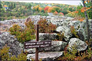
The most spectacular and varied hiking is around Devil's Lake State Park, just south of the Wisconsin Dells.
The best forest hiking and longest developed stretch is around Timm's Hill and in Taylor County, north of Medford in north-central Wisconsin.
The best short hikes are in the Dalles of the St Croix, where there's an Interstate State Park both in Wisconsin and Minnesota.
The spots below are listed from west to east.
The best maps are in the Ice Age Trail Atlas, $35, and Companion Guide, $20. You can also use the map on the Ice Age Trail Alliance site (just keep clicking to zoom in).
Interstate State Park, St. Croix Falls
The clifftop Pothole Trail in this park along the St. Croix River is the best place to watch the abundant action: climbers on the basalt cliff face, sightseers across the river on Angle Rock, where the river takes a hard right; and paddlewheelers, which have been taking tourists to see the formations since 1904.
There's the craggy Old Man of the Dalles, the Elephant's Head, the Turk with a turban and the Holy Cross, for which French fur-traders named the river.
© Beth Gauper
It's lined by cylindrical potholes, drilled into solid rock by whirlpools laced with gravel. They're even bigger across the river in Minnesota's Interstate State Park.
Standing at the bottom of the 35-foot-deep Bake Oven, touching walls as smooth as vinyl, it's easy to imagine the scene 12,000 years ago, when sheets of water from the melting Wisconsin Glacier roared past , creating what now is the St. Croix River Valley.
Named Dalles of the St. Croix — dalle is French for rocky slab — this gorge is a first cousin of the Wisconsin Dells, which were created in a week by a nearly apocalyptic rush of glacial meltwater.
Minnesota hikers can avoid Wisconsin's $10 out-of-state parking fee simply by walking across the U.S. 8 bridge from Taylors Falls; the trail starts on the opposite end.
For more, see Sightseeing on the St. Croix.
Chippewa Moraine Interpretive Center, New Auburn
© Beth Gauper
Ten miles east of U.S. 53, just northeast of Bloomer, this interpretive center sits high on a pile of silted clay, once the bottom of a glacial lake.
In this area, a 600-foot-high sheet of melting ice dropped massive chunks of ice that were buried by debris and eventually melted, creating the lumpy moraine and hundreds of kettle lakes.
From the center, the wide Woolly Mammoth Nature Trail winds through a bowl sprinkled with kettle lakes. The Ice Age Trail balloons into a 4½-mile loop around the center, then extends west to Brunet Island State Park on the Chippewa River.
On the first Saturday of October, the local Ice Age volunteer chapter holds a Parade of Colors Fall Hike from the center, providing a shuttle and refreshments at the hike's end. Hikers pass 21 lakes on the six-mile trek.
Timm's Hill near Ogema
This modest hill, six miles east of Ogema off Wisconsin 86, is the highest point in Wisconsin at 1,951½ feet.
© Beth Gauper
It's the region's easiest high point to visit; just drive up to Timm's Hill County Park and walk a short distance. For a view, you have to climb an observation tower.
However, it's also the northern trailhead of 10-mile Timm's Hill National Trail, which heads south to the beautiful Rib Lake section of the Ice Age Trail.
The area also is a great place for driving, with Wisconsin's Rustic Road 62 passing by its feet and Rustic Road 1 just to the south.
For more, see Trek to Timm's Hill.
Mondeaux Flowage near Medford
One of the Ice Age Trail's best eskers is 10 miles west of Wisconsin 13, north of Medford. (One of the others is right in St. Croix Falls, called the Wellness Esker because there's a hospital on it.)
At the edges of the glacier, streams that flowed through tunnels of ice deposited piles of sand and gravel, creating long, rounded ridges called eskers. On the shores of the Mondeaux Flowage, hikers walk on top of an esker.
It's fairly remote, in the middle of Chequamegon State Forest, but it's popular with familes. The Mondeaux Recreation Area has four U.S. Forest Service campgrounds with showers, a swimming beach, boat rentals and a store.
The log Mondeaux Dam Lodge has a café and sells ice cream and snacks.
For more about hiking in Taylor and Price counties, see Tracing the Ice Age Trail.
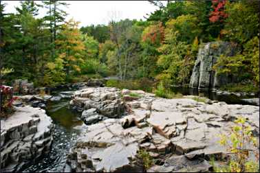
Dells of the Eau Claire River near Wausau
In this extremely picturesque stretch of the Eau Claire River, bedrock tilted and fractured. The rock is not basalt but rhyolite, another metamorphic rock that is so smooth it looks like oiled bronze.
© Beth Gauper
Its surface is gorgeous, but so slick that a sign at the trailhead warns, "This park possesses dangerous natural features. Please supervise children." Dogs have a hard time, too.
Water tumbles where it can, creating frothing rapids and waterfalls that must be epic in spring. Potholes were drilled into the rhyolite along with unusually large, oval percussion marks, which look like the footprints of a shaggy, 10,000-pound beast.
Trails follow both sides of the river, connected by bridges. Cliffs line the north side, and the south banks are dark with trees — hemlock, sugar maple, yellow birch, and Canada yew. Part of the area is the Dells of the Eau Claire River state natural area.
From Wisconsin 29, 15 miles east of Wausau, take County Road Y north from Hatley.
For more about the area, see Wausau's liquid assets.
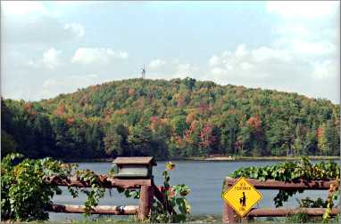
Rib Mountain State Park in Wausau
This hill, rising from the marshy plains around Wausau and visible from miles away, looks like something remarkable, if not the state's high point. It's only the fourth-highest now, at 1,940 feet, though it's the tallest hill when measured from the plain that surrounds it.
© Beth Gauper
A road winds to the top, where a climb up the 60-foot observation tower affords one the region's great views. Rib Mountain State Park trails radiate from the top of the mountain, all lined by fractured quartzite.
In winter, it's a good place to snowshoe, and naturalists lead guided hikes in January and February.
The park is just south of the junction of Wisconsin 29 and U.S. 51. For more, see Winter in Wausau.
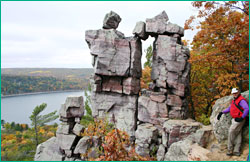
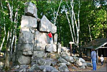
Devil's Lake State Park near Baraboo
This one place, just south of Baraboo, tells the entire geological story of this area. Pink quartzite cliffs, prized by climbers, once was sand at the edge of an iron-rich ocean, and ripple marks show where waves washed 2 billion years ago.
An ancient river cut the canyon but was plugged by debris carried by the last glacier, causing the rise of the spring-fed lake, often called the state's clearest. The former riverway still can be seen plainly from the West Bluff Trail, stretching into the horizon.
Hundreds of 800-ton quartzite blocks lie along the west side of the lake, tumbled from the bluffs.
On the East Bluff Trail, hikers weave among stacks of fractured rock that have inspired such names as Balanced Rock and Devil's Doorway.
From the East Bluff Trail, the Ice Age Trail continues to Parfrey's Glen, the state's oldest natural area, an unparalleled hike of 10 miles one-way. The glen is a very narrow gorge with walls of plum-puddingstone, globes of quartzite embedded in sandstone.
For more, see The divine Devil's Lake.
For an explanation of the forces that created the area, see High drama at Devil's Lake.
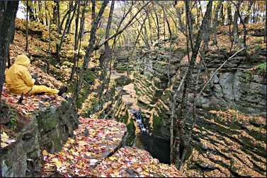
Pewits Nest state natural area near Baraboo
© Beth Gauper
This creek gorge that was named for "an individual who lived in the solid sandstone, like a gnome in a cavern ... this dwelling resembled the nest of a phoebe (or peewit, an earlier name for this bird), hence dubbed by early settlers the 'Peewit's Nest.'"
It's surrounded by farm fields, which makes it seem otherworldly. Dozens of tiny terraces form the moist walls of the gorge, and from the top, trails lead to a black pool fed by a small waterfall on Skillet Creek.
A canopy of cedar, pine, hemlock and birch covers the gorge, adding to the hidden quality.
From U.S. 12 south of Baraboo, head west on County Road W. It's 1½ miles to a small parking area. Don't park on the road.
For more about the area, see Baraboo's gilt complex and Pilgrimage to the Baraboo Hills.
Kettle Moraine State Forest
This rocky, boggy forest is where city folk from Milwaukee, Madison and Chicago go for fresh air and a dose of wilderness.
It's in two parts: the Northern Unit is just west of Sheboygan, and the Southern Unit is west of Milwaukee and Racine. Both are threaded with hiking, mountain biking and cross-country skiing trails.
© Beth Gauper
In the Northern Unit, the 3½-mile Parnell Tower Trail takes hikers to the Parnell Esker and a 60-foot observation tower. The Henry S. Reuss Ice Age Visitor Center schedules naturalist programs throughout the year.
In the Southern Unit, the popular Scuppernong Trail has three loops of various lengths at the intersection of Wisconsin 67 and County Road ZZ north of Eagle.
Potawatomi State Park, Sturgeon Bay
Potawatomi State Park is the eastern trailhead of the Ice Age Trail. From a 75-foot observation tower that supplies a panoramic view across Green Bay, a three-mile stretch of the trail hugs the waters of Sturgeon Bay.
Twisted cedars jut out of craggy blocks of limestone, and it seems hidden away, though much of it is near Shore Road. This is the kind of trail children love, with lots of nooks and crannies to explore.
For hikers, this is as good as it gets. For more about Sturgeon Bay, see The door to Door County.