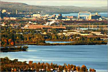
Duluth's other waterfront
The quiet St. Louis River is a hub for hikers, bikers, paddlers and train buffs.
© Beth Gauper
Once, a wind-whipped sand spit was not the most desirable address in Duluth.
Today, tourists want to hang out on Canal Park and stay in beach cottages on Park Point, just beyond the Aerial Lift Bridge. But the Ojibwe preferred the calmer estuary of the St. Louis River, which flows into Lake Superior at what today is Duluth-Superior Harbor.
The French explorer Daniel Greysolon, Sieur du Lhut, for whom the city was named, didn't waste much time on the lakefront when he arrived in 1679.
Nor did the early fur traders, who hustled straight up the St. Louis, which, via the little Savanna River, connects Lake Superior to the Mississippi.
The St. Louis looks sleepy, but it's the largest Lake Superior tributary in the United States. With Ontario's Nipigon River, it contributes about one-fourth of the lake's annual water input.
John Jacob Astor built his fur post next to the Ojibwe village in Fond du Lac, 20 river miles from the lake, and operated it for three decades, until 1847. When financier Jay Cooke brought in the first railroad, it came in along the banks of the St. Louis.
Tourists once came to the St. Louis, too, taking a sidewheeler on Sunday excursions to Fond du Lac, where a log reproduction of Astor's post was built in 1935.
But the mills that lined the banks eventually polluted the river, giving it a stench of boiled cabbage and rotting fish that sent tourists fleeing. The mills also deposited mercury-laden waste that poisoned the fish, discouraging fishermen.
Until the Environmental Protection Agency stepped in to clean it up, few wanted to be close to the St. Louis River.
"Thirty years ago, no one around here would have dreamed of going on it," said Dean Wolf, a Carlton native who was fishing from a river cove as a big whitewater-rafting group went by. "It's super, seeing all the rafting on the river now."
© Beth Gauper
The 4½-mile section of the river between Scanlon and Carlton, lined with nine rapids of Class I-IV difficulty, also is favored by kayakers and canoeists.
Trails and scenic roads follow the St. Louis from the harbor to Jay Cooke State Park.
The opportunities for recreation are remarkable: Canal Park may have the party, but the St. Louis River is the place to play.
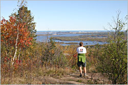
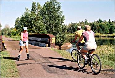
People can pick up four trails within a block of each other, at Grand Avenue and 75th Avenue in West Duluth.
The Kingsbury Creek trailhead of the Superior Hiking Trail and the DWP Trail (Duluth, Winnipeg and Pacific Railway) are just behind the Lake Superior Zoo.
The 70-mile Willard Munger State Trail, named for the longtime Duluth legislator who successfully pushed for the cleanup of the river, starts across the street, behind the Willard Munger Inn.
Its first 15 miles, through rock cuts up to Jay Cooke State Park and Carlton, are perhaps the most scenic on any Minnesota bicycle trail.
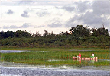
A walking trail also starts behind the Munger Inn. The five-mile Waabizheshikana(pronounced waa-bah-zhay-kuh-nuh), formerly the Western Waterfront Trail, surfaced with crushed limestone, follows the river's bays past cattail marshes that are prime habitat for waterfowl and other wildlife.
It is named for the Marten Clan of Ojibwe, which lived here. Even on weekends, the path is one of the quietest, least-frequented spots in Duluth.
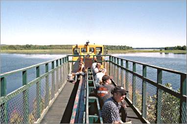
A block away, volunteer train buffs give rides on the Lake Superior & Mississippi Railroad, which arrived to huzzahs in 1870: "The lifeless corpse of Duluth . . . touched by the wand of Jay Cooke, sprang full-armed from the tomb," said one legislator at the time.
Only six miles of the line remain, but they're all scenic. Herons rise from cattail marshes just yards from the tracks, and the train occasionally has to stop so the fireman can remove ducks and turtles that have wandered up from the river.
© Beth Gauper
Conductors point out the site of the McDougall shipyard, which made the S.S. Meteor, now an attraction in Superior, and other whalebacks boats.
There's Morgan Park, the steel-company town that included perhaps the nation's first strip mall; traces of a giant steel mill, now the site of a Superfund cleanup; and an old paint factory that now houses luxury condos.
First, citizens groups and environmentalists successfully fought to return the river to its natural state.
Once it again became desirable, they had to fend off developers, who outbid the Nature Conservancy and bought 358-acre Clough Island for development into a $330 million resort with condominiums and a golf course.
The 2008 recession intervened with their plans, and two years later, the Nature Conservancy was able to buy it from the developers.
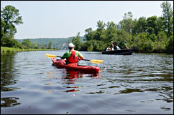
Kayakers like to paddle in and among the many peninsulas and islands, which once held speakeasies and stills but now are habitat for wildlife.
© Beth Gauper
The river estuary is the walleye nursery for western Lake Superior, she says, and the 170,000 sturgeon released into the river over the past three decades are breeding.
Eagles nest there, and 70 percent of the birds seen in Minnesota come through Duluth on fall and spring migrations.
Indian Point Campground rents canoes, and there are other access points. One of them is Chambers Grove Park in Fond du Lac, where Gary-New Duluth resident Tim Blazevic was hauling out his canoe one Sunday.
"My friends say, 'Oh, go to the Boundary Waters,' but I say, 'Why? I get it right here,' " he said. "You never know what you're going to see, whether it's your deer, beaver, otter or whatever."
Fond du Lac, French for "foot of the lake," is where Daniel Greysolon negotiated the first short-lived truce between the Ojibwe and Dakota, and where the first U.S.-Ojibwe treaty was signed in 1826.
Today, the neighborhood is a placid backwater, 14 road miles from downtown Duluth.
From there, Minnesota 210 twists up to Jay Cooke State Park, donated from the lands of a man who, according to an exhibit in the park, was "a rare good guy."
Here, voyageurs had a grueling seven-mile portage around a lethal stretch of Class VI falls and through house-sized boulders.
Modern-day visitors, of course, love the dramatic scenery along the river, lined by tilted slabs of slate and crossed by a suspension bridge.
This 29-mile stretch of river is a stunner, from the ferocious rapids upstream to the languid sloughs of the estuary.
Trip Tips: Duluth's St. Louis River
Getting there: From the Twin Cities, it's a two-hour drive on I-35 to Carlton, and another 20 minutes into Duluth.
© Beth Gauper
The scenic route is from Carlton along Minnesota 210, which follows the St. Louis River and segues into Minnesota 23 (Grand Avenue) in West Duluth.
For more about planning a trip to Duluth, see Duluth 101.
Bicycling: Many people start on the 70-mile Willard Munger State Trail behind the Munger Inn at Grand and 75th avenues; there's also a lot at 72nd and Grand. The 15-mile stretch to Carlton is uphill.
Walking: The Waabizheshikana, formerly Western Waterfront Trail, has two parking lots, one behind the Munger Inn and one off Grand on Fremont Street at 63rd Avenue West, from which the eastern stretch is paved.
For more, see Walking in Duluth.
Hiking: The most scenic Duluth sections of the Superior Hiking Trail are in West Duluth. Try the 3.2-mile stretch from Skyline Parkway at Getchell-Highland to the Lake Superior Zoo and, for great views of the river valley, the 4.3-mile hike from Magney-Snively Park past Bardon's Peak and Ely's Peak to 123rd Avenue, just off the Munger Trail.
For details, see Hiking in Duluth.
© Beth Gauper
Train ride: The Lake Superior & Mississippi Railroad, run by volunteers, travels along the St. Louis River for narrated two-hour, 12-mile round-trip tours on weekends from early June through early October.
It leaves from a parking lot across from the Lake Superior Zoo at Grand Avenue and 71st Avenue West.
Lake Superior Zoo: At this smaller zoo, many animals have the run of roomy, woodsy enclosures, and the playful otters and Alaskan coastal brown bears entertain visitors from their pools. Look for specials, such as $10 admission on Tuesdays.
Paddling: Pick up a copy of the St. Louis River Estuary Water Trail map, which shows 11 loops trails, at the St. Louis River Alliance office on the second floor of DeWitt-Seitz Marketplace on Canal Park.
Several outfitters offer kayak or canoe tours of the St. Louis, a state water trail, and Spirit Lake Marina rents canoes and kayaks as well as pontoon boats and bikes.
Near Carlton, Swiftwater Adventures offers whitewater-rafting trips above the Thomson Dam.
For details, see On the water in West Duluth.
Boat launches: There are landings at Clyde Avenue, off Grand Avenue in West Duluth, and at Boy Scout Landing, farther along the river off Minnesota 23.
Fishing: The St. Louis River estuary includes walleye, sturgeon, smallmouth bass and northern pike. Areas from which fish never should be eaten are posted.
© Beth Gauper
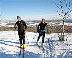
Skiing: The alpine runs on Spirit Mountain can be reached from its Grand Avenue Chalet.
Nearby, the Grand Avenue Nordic Center makes snow on 3.3 kilometers of trail, and there's a 1.7-kilometer connecting trail to the 22 kilometers of trail on the upper part of the hill.
Farther down Grand Avenue, there are 14 kilometers of hilly nordic trails at Magney-Snively Park.
For more, see Cross-country in Duluth and Relishing winter in Duluth.
Accommodations: The brick, one-story Willard Munger Inn, across from the Lake Superior Zoo, is the obvious choice. Built by the late legislator in 1954, it's a comfortable and inexpensive place to stay.
Some rooms have kitchens and whirlpools. Bikes and canoes are available for guests to use.
Across the river from Chambers Grove Park, Mont du Lac Resort has camper cabins on a swimming pond with a trampoline play structure for children. It also offers mountain biking, tubing and disc golf.
Camping: Indian Point Campground is right on the Waabizheshikana Trail and the St. Louis River; its entrance is at Grand and 75th avenues. Its sites are shady and well-maintained. Guests can rent bikes, kayaks and canoes.
Farther down Minnesota 23, at its junction with 210, Fond du Lac Campground is right on the river and near Chambers Grove Park.