Trying out the Border Route
On eight great day hikes, get a taste of this 65-mile trail through Minnesota's canoe country.
© Torsten Muller
In Minnesota canoe country, hikers get serious bragging rights by backpacking the Border Route Trail.
This 65-mile trail roughly parallels the Ontario border, mostly through the Boundary Waters Canoe Area Wilderness. The volunteers who maintain it can't use mechanized tools there, and signs aren't allowed.
Navigation isn't easy, and hikers frequently have to dodge blown-down trees.
They don't have to dodge other people, though. Backpacker magazine praised the trail's solitude and suggests, "Hike where others paddle."
Parts of the Border Route are easily reached from the Gunflint Trail and forest roads off the North Shore. So if you'd like to sample some of the best scenery with a fraction of the fuss, you can try it on a day hike.
The western trailhead is nine miles from the end of the Gunflint Trail, the 57-mile highway that starts in Grand Marais and dead-ends near the Canadian border. It connects with the Kekekabic Trail, which heads 39 miles west toward Ely.
The eastern trailhead is on the Swamp River, which flows into the Pigeon River, the international border. It's not far from historic Fort Charlotte, at the end of the 8½-mile Grand Portage that Lake Superior voyageurs used to get into the Canadian interior.
The Border Route does connect with the north end of the Superior Hiking Trail, which heads 310 miles down the North Shore to Duluth and Jay Cooke State Park.
All three trails now are part of the North Country National Scenic Trail between Montana and New York.
The Border Route Trail was built in the early 1970s by the Minnesota Rovers Outdoors Club, and many of its members still maintain it on trail-clearing trips through the Border Route Trail Association.
Anyone is welcome on the trips, most of which originate in the Twin Cities. The association also publishes a handy trail guide with maps.
There's also a Border Route Trail Meetup Group that schedules weekend and day trips on the trail.
Here are eight great day hikes on the Border Route, chosen and researched by Madison, Wis., hiker Todd McMahon.
Magnetic Rock
Head up the Gunflint Trail (County Road 12) to the Border Route's western trailhead, 47.8 miles from Grand Marais.
© Todd McMahon
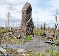
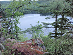
This is the starting point for a day hike to one of the most peculiar sight in the Boundary Waters — Magnetic Rock, a 60-foot upright slab of rock that makes compasses go haywire.
The trail meanders through rocky hills and valleys burned in the 2007 Ham Lake fire. You'll find Magnetic Rock 1½ miles from the trailhead.
And watch for wildflowers — the U.S. Forest Service calls this trail one of the best in the nation for seeing them.
Centennial Trail loop
This 3.3-mile loop was created in 2009 for the 100th anniversary of Superior National Forest and also is in the area burned by the 2007 Ham Lake fire.
It's actually part of the Kekekabic Trail, whose eastern trailhead is just a block from the Border Route's western trailhead.
Hike west on the Kek, and you'll pass a spur trail to the former site of the Old Gunflint Tower. Then you'll see the shaft of the ill-fated Paulsen Mine, filled with water and surrounded by a split-rail fence.
Half a mile from the mine, the Centennial Trail takes a sharp left off the Kek and starts heading southeast on a grade once used by the Port Arthur, Duluth & Western. This Canadian railroad crossed into the United States at the Gunflint Lake Narrows to reach the Paulsen Mine, which yielded only one trainload of iron ore.
The trail goes back to the Gunflint Trail along the old railroad grade, taking one detour up to a scenic overlook. It passes Tuscarora Lodge and Outfitters on Round Lake, then parallels the Gunflint Trail until it meets the Kek trailhead.
South Rim
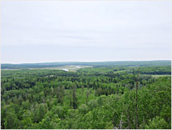
This four-mile section, popular with cross-country skiers in winter, follows a ridge with spectacular views of Gunflint Lake.
Gunflint Lodge and Gunflint Pines resort are at the western end, and Heston's Lodge is at the eastern end. When you are done, you can either walk back to your car using the Lonely Lake ski trail or arrange with one of the resorts to take you back to your car.
Bridal Veil Falls
There's one more easy day hike in the Upper Gunflint area. Park your car on North Loon Lake Road, near Heston's, and hike west on the Border Route for three miles.
Along the way, the trail skirts the shoreline of Loon Lake, then follows a ridge with great views of the eastern end of Gunflint Lake.
The area near Loon Lake was not burned by the Ham Lake fire, but the ridge was, and you'll be able to see a stark contrast.
© Todd McMahon
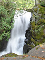
Eventually, you'll see Bridal Veil Falls, a 10-foot-wide chute of fast-moving water. A short spur leads to the main part of the falls.
The falls also can be reached from the south, using the Crab Lake Access Trail to connect with the Border Route. Park your car on Loon Lake Road (County Road 51) on the southeast side of the lake, near Loon Lake Lodge.
Stairway Falls and Rose Lake
In the Central Gunflint area, hikers can reach two of the trail's most scenic spots — and getting there is even easier if you use a canoe.
From the Gunflint Trail, drive up Hungry Jack Road to the Caribou Rock Trailhead. You can walk to Stairway Falls using the four-mile Caribou Rock Trail.
It offers fantastic views but is one of the more difficult trails in the Boundary Waters. If you have some canoeing skills, there's an easier way: Rent a canoe from Hungry Jack Lodge.
Then paddle across Bearskin Lake and haul your canoe across the 400-yard portage into Duncan Lake.
Once on Duncan Lake, canoe up to Stairway Portage and park your canoe near the portage landing. The portage trail connects with the Border Route Trail.
Spectacular Stairway Falls is near the trail junction and a large wooden staircase that canoeists use to portage from Duncan Lake to Rose Lake.
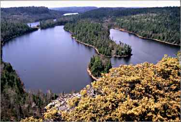
If you hike east of Stairway Falls on the Border Route for 1/8 mile, you'll get to the iconic overlook of Rose Lake, a favorite of photographers.
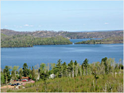
Watap Cliffs
This seven-mile hike also starts in the Central Gunflint, on 6-mile-long Clearwater Lake, one of the few BWCAW lakes where motorboats are allowed.
Take Clearwater Road to Clearwater Lake Lodge, where you will have called ahead to reserve a motorboat drop-off at the Two Mile Campsite, farther down the lake.
When you get to the campsite, start walking on the spur that connects to the Border Route Trail on top of the bluff. Take a right, and in less than a mile, you'll reach the Watap Cliffs, an amazing spot that overlooks Watap Lake.
Head back, but this time, when you get to the campsite spur, stay on the Border Route. The trail will take you down to Rove Lake. Be thankful that you are going down on this section, instead of going up.
Then the Border Route follows the shoreline of Rove Lake for about a mile until it comes to the portage to Daniels Lake. Take the portage trail for about ¾ mile until you reach the junction with Long Portage and the Daniels Lake Access Trail.
Take a left onto the Daniels Lake Access Trail. The trail is a former railroad bed, so it's nice and flat as it follows Daniels Lake for two miles. Then the trail takes a left turn, and after another mile, you'll reach Clearwater Road.
Take a right, and you'll soon be back at Clearwater Lake Lodge.
© Torsten Muller
John Lake Overlook
The next two hikes are on the eastern part of the trail and are reached from Minnesota 61 on the North Shore.
From Grand Marais, drive 19 miles along Lake Superior to Hovland. From there, drive 17 miles inland on the Arrowhead Trail, or County Road 16.
The Arrowhead Trail is paved for only three miles; the rest is a gravel road. Park at the Border Route trailhead on McFarland Lake and cross the bridge that separates McFarland Lake and Little John Lake.
The road takes a sharp turn, and you'll find the Border Route about 50 yards to your right.
For the first quarter-mile, the hike is flat. Then you'll climb for more than half a mile to the John Lake Overlook.
You can continue hiking along the ridge, which has views of the lake below, but the first overlook is the best. It's about a mile; head back to the trailhead the way you came.
© Todd McMahon
Pigeon River Cliffs
For your easternmost day hike, drive back down the Arrowhead Trail for about six miles, to the junction of Otter Lake Road.
Drive east on Otter Lake Road for about three miles, to the eastern trailhead of the Border Route Trail. There is a parking area off Otter Lake Road with a kiosk.
From here, you can either hike 1½ miles out and back to a spectacular overlook, or you can do a 7½-mile loop with several overlooks.
If you are doing the short version, just hike up the Border Route for ¾ mile and take a short spur trail to a spectacular 270-degree overlook.
If you are doing the long version, hike west on Otter Lake Road for 2½ miles. This portion of the hike isn't very scenic. Then take a trail to the right known as the Otter Lake Cutoff, on the east side of Otter Lake.
The Otter Lake Cutoff goes through a clear-cut area, then down a hill to meet up with the Border Route Trail.
Take a right on the Border Route and start a gradual uphill ascent to the first in a series of overlooks over the next four miles, on the Pigeon River Cliffs section of the trail.
You'll see about four overlooks, then descend and go through a clear-cut area. Up another hill, you'll see two more overlooks; the second is the 270-degree overlook from the short hike.
From there, it's ¾ mile back to the eastern trailhead.
© Todd McMahon
Trip Tips: Hiking the Border Route Trail
Getting there: Grand Marais, the jump-off for the Gunflint Trail, is 4½ to 5 hours from the Twin Cities.
It's another hour to the western trailhead of the Border Route on the Gunflint and also to the eastern trailhead off the Arrowhead Trail/County Road 16.
When to go: Expect quite a few ticks, flies and mosquitoes in late May and June. Many people think the best time to hike the trail is between snowmelt and bug arrival, usually in early May, or after the first frost in September.
What to bring: Most importantly, bring a map and compass. Also bring warm, non-cotton clothing, snacks and either water or a water filter to purify water taken from lakes or creeks.
You'll also need strong insect repellent, and consider spraying your clothes with Permethrin to ward off wood ticks as well as deer ticks.
Since you likely won't have cell-phone reception, you'll need an emergency kit in case you lose your way and need to spend a night in the woods.
Backpacker magazine suggests this lightweight survival kit, which can fit into a fanny pack: an emergency blanket, two fire starters (a cheap butane lighter is best), signaling device (a whistle, if nothing else), knife or razor blade and a square of heavy-duty aluminum foil for making a cup or cookpot.
For more, see Don't be a dope in the woods.
Day permits: You can fill out free permits for day hikes at trailheads.
More information: The Border Route Trail Association.
For more about the Superior Hiking Trail, see Trekking the Superior Hiking Trail and Hiking the North Shore.