North Shore by the mile
Planning a trip to this beloved part of Minnesota? Start at 0.0.
© Beth Gauper
If you don't know much about Minnesota's North Shore, trip-planning can be confusing.
For one thing, it's really the west shore of Lake Superior. People in Ontario don't get confused because they live on the real north shore. Chicagoans do get confused because they call their northern suburbs the North Shore.
This pointy corner of Minnesota also is called the Arrowhead Region. Some people call its roads by their names — Sawbill and Caribou — and some by their numbers — County Road 2 and County Road 4.
Some people heading north along the shore say they're heading east, and they're right.
Even if you know exactly where you are, it's still hard to plan a trip to the North Shore: There's so much to see and do, and everything passes in a flash.
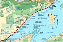
When I head up the shore, I take a blue fold-out brochure called North Shore Drive of Lake Superior, which lists the main attractions by mile marker, from 0.0 (Duluth's Canal Park) to 151.0 (the Canadian border).
Want to make sure you don't zoom by Palisade Head? It's at Mile Marker 56, two miles past Silver Bay.
Getting Temperance and Tettegouche state parks mixed up? Tettegouche is 2½ miles beyond Palisade Head, and Temperance is 22 miles further, just past Schroeder.
Published since 1937, my favorite blue brochure has been discontinued, so I guard my remaining copies jealously.
This scenic highway, also a national scenic byway, is hallowed ground to Minnesotans and many people in surrounding states. If you're planning a trip but are overwhelmed by the choices, here are the places you may want to see — along with mile markers.
© America's Byways
In summer and fall, make sure you have a place to stay. For more on hiking, skiing, dining, lodging and sightseeing, see our large North Shore section.
The beginning
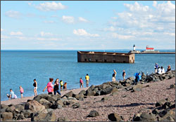
0.0 Canal Park in Duluth. Tourists now flock to the part of town once filled with seedy bars and old warehouses. They can't resist watching giant ore boats head into the harbor under the Aerial Lift Bridge, or strolling along the Lakewalk as sea gulls screech for handouts.
There's shopping at DeWitt-Seitz Marketplace, cool exhibits in the Marine Museum, boat excursions to take from the harbor and train rides from the nearby Depot. Kids love it all, especially jumping on the rocks.
5.1 Lester River. The beautiful park along this river once was a weekend destination for city folk. The nearly 1-mile Lester Park Trail follows the river, off Superior Street and 61st Avenue East. In summer, you'll find some of Duluth's great swimming holes. In winter, the park has superbly groomed ski trails.
5.2 Scenic 61. Just beyond Duluth's Kitchi-Gammi Park, also called Brighton Beach, turn right and take the scenic route to Two Harbors. In June, it's the route for Grandma's Marathon.
13.1 New Scenic Café. This sunny little spot is a good place to stop for coffee and fruit pie (among the region's best) or a meal.
15.0 Stony Point. Watch for the turnoff to a one-mile drive that hugs a point. It's known for giant waves and the surfers who congregate to catch them.
20.0 Knife River. You can buy smoked fish in this little fishing village, and there's also a darling candy store, plus a campground and marina.
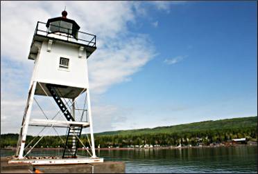
24.0 Two Harbors. Don't whiz past — turn right and go down to Lighthouse Point to see the North Shore's only real lighthouse, now an inn, and walk the enchanting Sonju Trail. If you're lucky, you'll see an ore boat being loaded.
In the downtown area, stop in the convivial taproom of Castle Danger Brewing for a cold one.
© Beth Gauper
The near shore
36.0 Rustic Inn Cafe. For the feel of the old North Shore, stop for a bite in this 1920s log-cabin cafe, most famous for its pies.
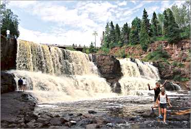
39.5 Gooseberry Falls State Park. It doesn't cost anything to park here and see the falls, which makes this the most-visited state park except for Fort Snelling in the Twin Cities.
Kids love clambering around on the rocks; bring water shoes. If it's a warm day, follow the river down to its mouth and you'll find a good spot to swim in Lake Superior. The falls also are fun to visit in winter, when they're frozen.
From here, you can ride the paved Gitchi-Gami State Trail to Split Rock Lighthouse and Beaver Bay.
43.5 Split Rock River. From the parking area, there's a great five-mile hike up the west side of the river and around, a rare loop on the Superior Hiking Trail.
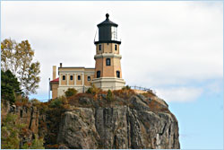
46.0 Split Rock Lighthouse State Park and Historic Site. The picturesque yellow lighthouse is a National Historic Landmark, one of only two Great Lakes lighthouses to get the designation.
Built after the Mataafa Blow of 1905 damaged 29 ships on Lake Superior — sinking the Madeira on Gold Rock, just across the cove — it became a tourist favorite after the highway was paved in 1924.
The state park has hiking trails, a beach and the best views of the lighthouse. Sites at the campground, tent and hike-in only, are the hardest to get in the state.
50.0 Beaver Bay. This busy little town is the home of the Agate Shop, a good place to see spectacular examples of the state gemstone, and many places to eat.
51.0 Beaver River. The beach at the mouth of this river is one of the best places to look for agates.
54.0 Silver Bay. On the south end of Black Beach Park, there's a scenic black-sand beach that's nice for picnics. On the other side of the highway, North Shore Adventure Park is a high-ropes course with ziplines.
In the hills above town, the 11-mile stretch of the Superior Hiking Trail from Silver Bay to Minnesota 1 is one of the most scenic (and most challenging), passing Bean and Bear lakes in Tettegouche State Park, Round Mountain, Mount Trudee and High Falls on the Baptism River.
© Beth Gauper
You can also see Bean and Bear lakes on a great day hike that starts from the Silver Bay information center, the 7.6-mile Twin Lakes Trail loop.
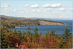
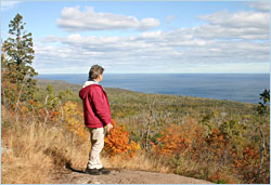
56.0 Palisade Head. It's a steep drive up to this clifftop with a spectacular view down the cliff-lined shore to Shovel Point. Bring a picnic — and watch your kids.
58.5 Tettegouche State Park. Park for free in the lot and walk the half-mile trail to Shovel Point, where basalt headlands form a coastline that looks more like northern California than Minnesota. The view, which includes Palisade Head to the south, is incomparable.
60.2 Minnesota 1. This is how you get to Illgen Falls and Illgen Falls Cabin in the upper part of Tettegouche State Park. Go a little farther and you'll reach the town of Finland, Wolf Ridge Environmental Center and Crosby-Manitou State Park (on County Road 7).
Keep going through Superior National Forest and you'll reach Ely.
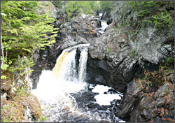
71.3 Caribou River. A 1½-mile trail leads to Caribou Falls. In winter, this is a good snowshoeing route.
73.0 Sugarloaf Cove. This nature preserve is one of the secret spots on the North Shore, where you still can see all the stones and cool stuff that used to be on all North Shore beaches before people carted them away for landscaping.
A one-mile interpretive trail winds through a red-pine plantation and alder thicket to a U-shaped cobblestone cove and crosses an old tombolo on a boardwalk. In the log nature center, interpretive staff give Saturday programs.
79.0 Cross River. There's a lovely waterfall here, best seen from Lamb's Resort and Campground on the south side of the river. There's also a bakery and the Cross River Heritage Center.
On the north side of the river, a road leads to Father Baraga's Cross.
80.4 Temperance River State Park. Trails at this park, named because the river has no bar at its mouth, follow the tortuous course of the Temperance River, seething and twisting like a flume ride from hell. Pebbles in the swirling water have scraped potholes in the riverbed and in the sides of the gorge.
© Beth Gauper
A lot of people swim here, but you shouldn't — some have drowned.
Park trails lead into the Superior Hiking Trail. It's a three-mile hike to Carlton Peak, whose 924-foot summit commands a spectacular view up and down the shore.
Skiing and hiking central
82.4 Tofte U.S. Forest Service ranger station. Pick up Boundary Waters permits and information on local hikes.
83.0 Tofte. This formerly quiet fishing village is the home of the large Bluefin Bay Resort and its Coho Cafe, a good place to stop for a sandwich, pizza or dessert.
83.4 Sawbill Trail/County Road 2. This 23-mile trail, roughly following the Temperance River, ends in Sawbill Lake, an entry point to a quiet part of the Boundary Waters Canoe Area Wilderness.
© Beth Gauper
Three miles up the trail, you'll reach the Britton Peak trailhead of the Superior Hiking Trail. From here, it's a three-mile round-trip to Carlton Peak.
Britton Peak also is the main trailhead for the Sugarbush ski-trail system, one of the best places to cross-country ski in winter. The Moose Fence is farther up the road on the right.
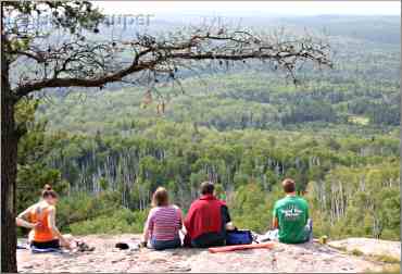
87.0 Onion River Road/Forest Road 336. This is how you get to the trailhead for the very popular two-mile Oberg Mountain hiking loop, where frequent overlooks give hikers views of the lake and inland maple forest.
It's two miles uphill to the parking area. From the other side of the parking area, the Superior Hiking Trail leads to Leveaux Mountain. It's a one-mile hike to a spur trail that goes to the summit.
The parking area also is a trailhead for the Sugarbush ski trails in winter.
© Beth Gauper
90.1 Lutsen Mountains. Go up the hill for skiing in winter. In summer, take a few rides down the Alpine Slide or hike east on the Superior Hiking Trail to Lake Agnes.
92.0 Caribou Trail/County Road 4. This is one way to get to the trailhead for Eagle Mountain, the highest point in Minnesota. Drive to Forest Road 153, then four miles east to the trailhead.
99.8 Cascade River State Park. The trails that hug both sides of the river are gorgeous, especially in spring, when they're lined by wildflowers.
© Beth Gauper
Don't miss the Upper Cascade, where the trail is lined with old cedars and feathery ferns and hikers can sit on the shore watching the river tumble over a series of small falls.
It's a challenging but very beautiful eight-mile round-trip up the river to the County Road 45 bridge and back down the other side.
104.0 Good Harbor Bay/Cutface Creek wayside. This is a good place to look for Thomsonite, a semiprecious gemstone with bands of pink and green that formed out of a single lava flow. It's only found here, along a six-mile stretch of shoreline.
Heading into town
110.0 Grand Marais. This harbor village has everything a tourist could want: shopping, restaurants, hotels, festivals, nightlife.
Be sure to walk out to the harbor light on the breakwall and to Artists' Point, where narrow trails lead through cedars and spruce. Children love playing in the rocks between the point and the old Coast Guard station.
© Beth Gauper
110.5 Start of the Gunflint Trail. This 57-mile road, also a national scenic byway, is lined by resorts, some of them on lakes that lead into the Boundary Waters Canoe Area Wilderness.
The road heads north, then west, and dead-ends near the Canadian border. It doesn't connect to Ely except by obscure gravel forest roads.
114.0 Devil Track River. On the rim of this deep, narrow canyon is a 2.4-mile stretch of the Superior Hiking Trail, with views of the red cliffs and waterfalls below. The river itself is a favorite snowshoeing destination in winter.
118.7 Kadunce Creek/River. A trail follows the rust-tinted waters of the Kadunce through its narrow gorge. It's a spectacular and intimate little hike, 1½ miles round-trip, and the cobblestone beach opposite the wayside is one of the shore's prettiest.
123.8 Judge C.R. Magney State Park. Trails in this park, named after the populist who proclaimed, "Our state parks are everyman's country estate," follow the Brule River past three waterfalls: the Lower, the Upper and Devil's Kettle.
At the Devil's Kettle, the river splits, half cascading 50 feet into a pool and the other disappearing into a pothole; no one know where it ends up. It's 2½ miles round-trip.
© Beth Gauper
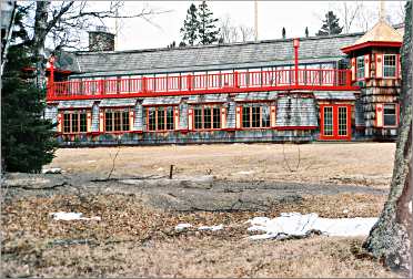
124.0 Naniboujou Lodge. This striking lodge was built in the heyday of the Jazz Age, just before the stock-market crash. Today, it's a quiet retreat, one of the best places to stay on the North Shore.
The restaurant in the Great Hall, painted with vivid Cree-style designs, is open to the public. It's especially popular for Sunday brunch.
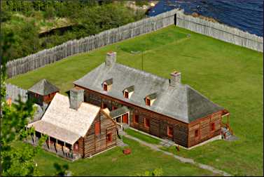
145.0 Grand Portage National Monument. This re-created North West Company post at the end of an 8½-mile big detour — the grand portage — around rapids on the Pigeon River once was the center of the fur-trade universe.
Costumed interpreters show visitors around. On a typical day, they can watch historic weapons being fired, hear a bagpiper, try on the clothing of the fur trade, play voyageur games and see a canoe being built.
Admission is free. Down the road, the Heritage Center highlights Ojibwe culture and contributions to the fur trade.
145.0 Boat service to Isle Royale. From the Grand Portage marina, ferries take tourists to Isle Royale National Park. It's a long way to travel for a day trip — three hours each way to Windigo — but same-day round-trip fares are available.
© Beth Gauper
150.8 Grand Portage State Park. The Pigeon River, which marks the international border, is the largest on the North Shore and was the bane of voyageurs.
Its lower 20 miles, a series of cataracts and chasms, is unnavigable, so the paddlers had to make an 8½-mile uphill portage before they could travel into the interior.
Today, visitors can follow a half-mile, handicapped-accessible trail to the state's tallest waterfall, gorgeous High Falls, cascading 120 feet over a sheer basalt wall. The Middle Falls Trail goes farther, over ridge tops, about three miles.
The border and beyond
151.0 Canadian border. This is the end of Minnesota and the beginning of Ontario, which is on Eastern Standard Time, an hour later. If you cross into Canada, make sure you have a passport (and no drugs, guns, Mace or other weapons).
From the Ontario visitors center, you can hike a trail to the top of High Falls, for a spectacular view up and down the Pigeon River.
190.0 Thunder Bay. This sprawling port town isn't pretty (except around the marina in Port Arthur), but there is a lot to do, and it has great places to eat.
Want to keep going? The scenery doesn't end here.
For more, see Lake Superior's greatest hits and Planning a Circle Tour.