Mississippi panoramas
Take in the views from 500 feet above the famous river.
© Beth Gauper
For centuries, blufftop views of the Mississippi have inspired superlatives.
Jonathan Carver called the view from Barn Bluff "the most beautiful prospect that imagination can form." Stephen Long said, "The sublime and beautiful (are) here blended in the most enchanting manner."
Those early explorers embellished their speech to impress folks back home. Nowadays, most people who take in the scenery just say "Wow."
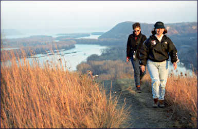
Breathtaking panoramas start in the Twin Cities gorge and continue to Barn Bluff, a boxy mound that rises between Red Wing and the river.
From there, the Mississippi widens into Lake Pepin, which dissolves into a tangle of sloughs and islands, marking the 260-mile-long Upper Mississippi River National Wildlife and Fish Refuge.
The stretch from Winona to the Rhine-like river valley of northeast Iowa is perhaps the most beautiful part of the entire Mississippi River, lined with rounded bluffs.
On many of them, people can get a bird's-eye view up and down the valley.
Turkey vultures and pelicans fly by at eye level. But the church spires and silos of civilization look tiny, like details in a diorama.
The world looks different, 500 feet up. Each view is well worth the trouble to get there.
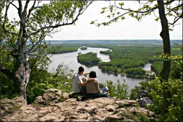
In fall, these panoramas are especially picturesque. Expect peak colors to start in early October and work their way south. Here's a gallery of a dozen great views between the Twin Cities and Dubuque.
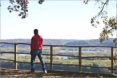
River gorge from end of Summit Avenue, St. Paul
Start your tour right in the middle of the urban area, on the only gorge along the river's entire length. The best viewpoint on this heavily wooded stretch, carved by the steady upstream march of St. Anthony Falls, is at the end of Summit Avenue in St. Paul.
© Beth Gauper
Walk behind the World War I monument to a fenced overlook, then climb down to a limestone ledge that juts over the bluff. From here, there's an unobstructed view north toward downtown Minneapolis and south to the Ford Parkway bridge.
Steep trails lead down to the river, where you can hunt for fossils or watch rowers, canoeists and kayakers.
It's just south of the Lake Street/Marshall Avenue bridge, along East River Parkway. There's a small parking area.
Another great Twin Cities overlook is Indian Mounds Regional Park in St. Paul, on the bluff east of downtown. To get there, take the Warner Road along the river and turn left on U.S. 61 and then Burns Avenue. From I-94, take the Johnson Parkway exit south to Burns Avenue.
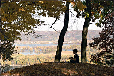
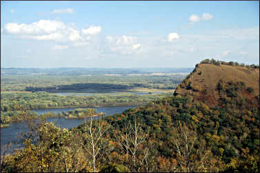
Barn Bluff, Red Wing, Minnesota
French explorers called this boxy bluff Mount La Grange, or barn mountain. From its flat top, 18th-century explorer Jonathan Carver said he saw "the most beautiful prospect that imagination can form."
© Beth Gauper
It sits right in the path of the Mississippi, which had to make a sharp turn to get around it.
The main path follows the north side of the 343-foot bluff, shady and cool on hot afternoons, and passes a vertical rock face frequented by climbers. At the north end of the bluff, there's an overlook and a grassy slope that faces town.
From there, hikers can watch traffic crawl past the brick storefronts and grain elevators of Red Wing and barges chug toward St. Paul. It's also a popular spot to watch Fourth of July fireworks.
A path atop the bluff leads through prairie to the southern overlook, where it dead-ends; those who want to return on the sunny south face have to return to the overlook before heading down.
To get there, take East Fifth Street south from downtown Red Wing; it leads straight to the foot of Barn Bluff.

© Beth Gauper
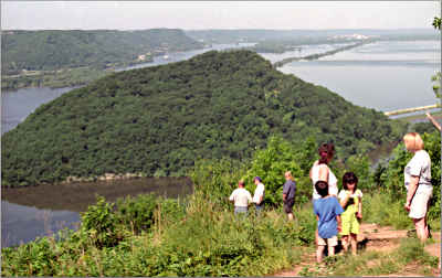
Sorin's Bluff in Memorial Park, Red Wing
For a really great lengthwise view of Barn Bluff, climb this lesser-known bluff just across from it. You'll also get a good view of the High Bridge, the town, the sharp elbow of the Mississippi and the Prairie Island nuclear-power plant to the north.
This view is disabled-accessible; climb it by car from East Seventh Street. Memorial Park includes round stone picnic tables, a disc-golf course, mountain-bike trails and, in winter, four miles of challenging ski trails.
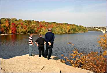
Frontenac State Park, on Lake Pepin
Frontenac State Park occupies a prominent point on the Mississippi, a well-known landmark for steamboat captains.
One overlook can be reached by car, but the steep, bluffside trails also offer views — in the spring, of wildflowers and migrating songbirds, as well as the river. From the nondescript town of Frontenac Station, turn east off U.S. 61 and drive up to the state park.
If you have a minute, drive the other way through old Frontenac, on the river. Founded in 1854 by the scions of an aristocratic Cincinnati family, who had come up the Mississippi to hunt, it became Minnesota's first resort area when Israel Garrard opened the Lake Side Hotel in 1865.
The general's 1854 St. Hubert's Lodge is still there, a French Gallery-style private house with a big, two-level veranda. It's the anchor of "the Front Row," which includes Dacotah Cottage, built by his brother Lewis in 1858; and the 1854 Locust Lodge, built for his business partner.
Thanks to Israel Garrard, the railroad never came through quiet Frontenac. To keep it away, he donated land two miles inland, and it was built there.
© Beth Gauper
Buena Vista Park, Alma, Wisconsin
This wide-open limestone outcropping on the bluffs 500 feet above Alma (pronounced EL-ma by locals) provides a view of the river valley that's nearly hypnotic.
There's a view of Lock and Dam 4, the town fishing float and the wide river plain, broken by the channels and islands of the wildlife refuge.
The park is a two-mile drive from the south edge of town, which has just two streets, a commercial stretch along the highway and a residential area set into the steep bluff.
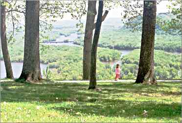
Garvin Heights, Winona, Minnesota
From the Garvin Heights overlook, 575 feet above the valley, there are 20-mile views up and down the river valley.

© Beth Gauper
Lake Winona is just below, and the town rolls toward the river, with its collection of striking churches and commercial buildings; two sections of downtown are National Historic Districts.
This view — actually, the view from the nearby Sugarloaf outcropping — even impressed the notoriously unsentimental Lt. Zebulon Pike, who came through in 1805 and called it "a prospect so variegated and romantic that a man may scarcely expect to enjoy such a one but twice or thrice in the course of his life."
To get there, turn west off U.S. 61 onto Garvin Heights Road.
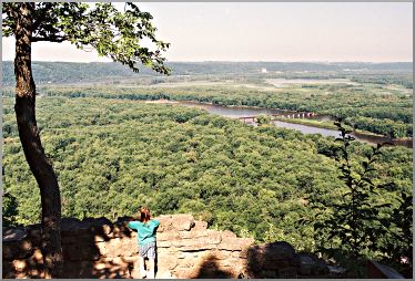
Great River Bluffs State Park, south of Winona
Great River Bluffs State Park, 20 miles south of Winona, has perhaps the highest overlook on the Upper Mississippi and is a great hiking destination, especially in spring and fall.
© Beth Gauper
The trail to King's Bluff provides views of the river valley as well as Queen's Bluff, a state scientific and natural area that can be hiked only with a permit. On the sun-baked sides of the bluffs, unusual plant species flourish on goat prairies.
Shorter trails lead to other overlooks. According to river buff Duke Addicks, writing in Big River magazine, the overlook off the picnic area is the highest on the Upper Mississippi at 631 feet above the river.
If you're heading south on U.S. 61, take County Road 3, also Apple Blossom Scenic Byway, to the park entrance.
If coming from the south, take Interstate 90 to County Road 12 south, which connects to County Road 3 north.
Brady's Bluff, Trempealeau, Wisconsin
It takes some effort to reach the top of 520-foot Brady's Bluff, but the view is magnificent.
© Beth Gauper
The towers and domes of Winona gleam 15 miles to the north, and just below the bluff is little Trempealeau Mountain, which is ringed by the river and was named by French explorers La Montagne Qui Trempe a l'Eau, or, "the mountain that soaks in the water."
It's also a bird-watching aerie. Upriver, the Trempealeau National Wildlife Refuge draws flocks of migrating waterfowl; downriver, the Van Loon State Wildlife Area bottomlands attract still more.
From Trempealeau, which sits right on the river, drive north into Perrot State Park and take one of three hiking trails to the bluff top.
In spring, Brady's Bluff is one of the region's best places to find spring wildflowers, especially the jeweled shooting star.
Grandad Bluff, La Crosse, Wisconsin
This windswept bluff, standing by itself on the east edge of La Crosse, is impossible to miss.
It rises 590 feet above the sandy plain on which sits the town, named by French traders for the ball game played by local Winnebago, or Ho Chunk, and settled by early fur traders.
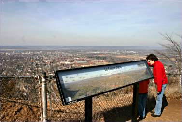
© Beth Gauper
The sweeping views from Grandad Bluff include the islands and channels created by the Black and La Crosse rivers as they flow into the Mississippi. On a plaque, landmarks are labeled, including the bridges over the Mississippi.
To get there, drive across town along Main Street. A road winds around the bluff and up, passing the Alpine Inn, where a blue neon sign hangs in a window: "Thanks for getting your duff up the bluff."
On top, there's a limestone pavilion with fireplaces, picnic tables and a bathroom.
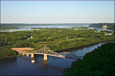
Mount Hosmer City Park, Lansing, Iowa
This is one of the great views, and it has a great story to match.
In 1851, Lansing was just a cluster of cabins, one of many that served passing steamboats. When one steamboat stopped to refuel, a 20-year-old passenger named Harriet Hosmer challenged a purser to a footrace up the steep bluff and won.
© Beth Gauper
Hosmer was a Massachusetts sculptor who had come west to study anatomy after being denied admittance to medical schools in the East.
After her trip up the Mississippi River, she returned to the East and then traveled to Rome, where she joined an international circle of artists that included novelist Nathaniel Hawthorne, who modeled one of his characters after her.
Now, tourists trace her path up the 450-foot bluff, driving up hairpin curves that seem almost vertical. The top is a park, with a playground, picnic tables and pavilion.
The best view is from a pullout; sit on the retaining wall and take in a three-state panorama, including Lansing's 1931 Black Hawk Bridge, perhaps the loveliest on the Upper Mississippi.
To get to Mount Hosmer, drive up Main Street and turn right on Sixth Street.
Effigy Mounds National Monument, Marquette, Iowa
High on the bluffs north of Marquette, this national park-service site preserves 195 burial mounds left by an ancient people.
© Beth Gauper
There are many mounds in the area. But these are remarkable because 31 are in the shapes of birds, reptiles and mammals, including the 137-foot-long Great Bear Mound.
In the visitors center, a film and exhibits show artifacts and explain what is known about the three cultures that built the mounds between 500 B.C. and 1300.
Effigy Mounds National Monument is a good place to hike, especially in fall. There are 14 miles of hiking trails on the heavily wooded bluffs, including two-mile Fire Point Trail, where overlooks provide sweeping views of the river valley.
For more on fall in northeast Iowa, see One fall swoop.
Pikes Peak State Park, McGregor, Iowa
These 500-foot bluffs above McGregor caught the eye of Lt. Zebulon Pike in 1805, when he was scouting for fort sites.
The fort instead was built across the river on the Prairie du Chien flats, so Pike's aerie, now Pikes Peak State Park, was turned over to tourists.
© Beth Gauper
Its wide-open views of the river plain, from overlooks and 12 miles of hiking trails that thread through ravines and forests, are mesmerizing.
Those who stand at its overlooks become voyeurs of life on the vast river plain below, where trains inch across the water on bridges, barges and houseboats lie at anchor and fishing boats putter into marshy corners.
Admission is free, as it is to all Iowa state parks. There's no interpretive center, but there's a concession stand that sells snacks and postcards.
To get there, take County Road X56 into the bluffs.
Wyalusing State Park, Prairie du Chien, Wisconsin
From the top of the 500-foot bluffs in Wyalusing State Park, just south of Prairie du Chien, there's a splendid panorama that includes the islands and sloughs around the mouth of the Wisconsin River.
© Beth Gauper
This is where Father Jacques Marquette and explorer Louis Joliet first paddled onto the Mississippi River — the first Europeans to see it — after traveling down the Wisconsin River from Green Bay in 1673.
Trails lead to overlooks and along effigy mounds left by ancient Indians, especially along the Sentinel Ridge Trail, which also includes a monument to the passenger pigeon.
Three shorter trails start from the campground, including the mile-long Bluff Trail, which takes hikers past the ocher limestone of Treasure Cave. The park also has eight miles of mountain-biking trails.
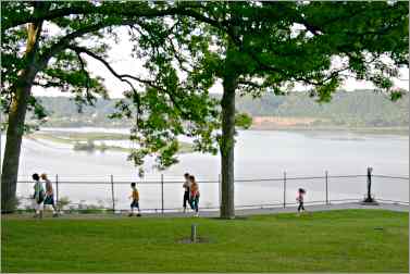
Eagle Point Park, Dubuque, Iowa
Dubuque, which is built on a series of hills, has many great views. One of them is from old-fashioned Eagle Point Park, just north of downtown and overlooking Lock and Dam 11.
© Beth Gauper
It was happy result of civil pride, wounded in 1907 with an East Coast parks expert visited and declared, "I have never seen a place where the Almighty has done more and mankind less, than Dubuque."
Judge Oliver Shiras spearheaded the drive to create a park, and Eagle Point opened in 1909, with overlooks, picnic areas and gardens. In the 1930s, beautiful Prairie-style pavilions were added by WPA crews.
For a good view of downtown Dubuque, which includes many church steeples, the gold-leaf dome of the courthouse and the bridge, ride the Fenelon Place funicular to the bluff above downtown.
For more river-valley views, hike the trails of the Mines of Spain State Recreation Area south of town.
Trip Tips: Upper Mississippi views
Bridges: South of the Twin Cities, they connect Red Wing and Bay City, Wabasha and Nelson, Winona and the bluffs north of Trempealeau, La Crescent and La Crosse, Lansing and De Soto, Marquette and Prairie du Chien and Dubuque and East Dubuque.
On the long stretch between Marquette and Dubuque, Iowa, the Cassville Car Ferry between a spot eight miles south of Guttenberg and Cassville, Wis., operates from 10 a.m. to 8 p.m. daily from Memorial Day to Labor Day and Fridays-Sundays in May, September and October.
Fare per car is $15, $10 for motorcycles and $5 for bicycles, cash only.
Handicapped-accessible views: Frontenac, Garvin Heights, Grandad Bluff, Mount Hosmer and Eagle Point Park. Buena Vista Park and Pikes Peak State Park are accessible to wheelchairs with some able-bodied help.