15 great fall views
From these overlooks, see rolling waves of color light up the landscape.
© Beth Gauper
In autumn, the pilgrims head for Holy Hill.
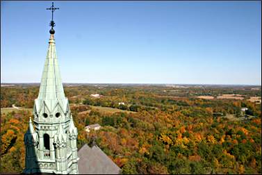
Some want to pay homage to the Blessed Virgin Mary, for whom the basilica was built in 1930. But many others just want to see the amazing view, which includes the Milwaukee skyline and surrounding Kettle Moraine State Forest, dappled with colors.
The basilica was built atop a kame — a mound filled with glacial rubble — that has one of the highest elevations in southeast Wisconsin and the highest in the 120-mile-long kettle moraine, where two lobes of the last glacier collided.
It's one of 15 great overlooks that are easy to reach on a lovely fall day.
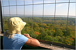
Holy Hill near Hartford, Wis.
The view of the basilica's soaring steeples, rising from the treetops, is nearly as striking as the view from the top of the tower.
Hikers can see it from the Ice Age National Scenic Trail, which winds through the property. The best view is from the south, where lovely Rustic Road 33 winds past meadows and through canopies of trees.
The basilica is formally known as the National Shrine of Mary, Help of Christians. It's 178 steps to the top of the tower, but you can see a view from a deck.
There's a gift shop, a picnic area and a cafe that's open every day except Monday.
To get there from Hartford, take Wisconsin 83 five miles south, then Wisconsin 167 three miles east.
Starved Rock State Park, Utica, Ill.
In northern Illinois, this park was named for a 125-foot butte along the Illinois River, where the Potawatomi and Ottawa supposedly trapped a band of Illini.
Not likely, but the view of the river valley is fabulous from the top of the limestone rock. Park visitors can see the barges, the locks of the Illinois Waterway Visitor Center across the river and often bald eagles — or, lacking those, turkey vultures.
For more, see Marvels of Starved Rock.
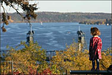
Pioneer Park, Stillwater, Minn.
© Beth Gauper
This picturesque old logging town on the St. Croix River, just east of St. Paul, was built on hills. From downtown, head north on Second Street to Pioneer Park, which has a panoramic view of the river valley, downtown and the 1931 lift bridge.
There are picnic tables and a playground. For more, see Excursion to Stillwater.
Prospect Park in Hudson, Wis.
On the other side of the St. Croix, this leafy park in Hudson is sheathed in fall colors and affords a pretty, steeple-studded view of the town below as well as a spectacular view up the river.
To get there from downtown, head up Walnut Street, turn south of Third Street, go up the hill and turn left on Blakeman Avenue. There's a picnic table and a swinging bench.
There's another good view from Birkmose Park, off Coulee Road between downtown and I-94.
For more, see Getaway on the St. Croix.
Mississippi Gorge overlook in St. Paul
© Beth Gauper
The only gorge along the Mississippi River's entire length runs through the Twin Cities. The best viewpoint on this heavily wooded stretch, carved by the steady upstream march of St. Anthony Falls, is at the end of Summit Avenue in St. Paul.
Walk behind the World War I monument to a fenced overlook, then climb down to a limestone ledge that juts over the bluff. From here, there's an unobstructed view north toward downtown Minneapolis and south to the Ford Parkway bridge.
Steep trails lead down to the river, where you can hunt for fossils or watch rowers, canoeists and kayakers.
It's just south of the Lake Street/Marshall Avenue bridge, along East River Parkway. There's a small parking area.
The Mississippi River Valley
There are too many great panoramas along the river to list here. The ones that can be reached easily by car include Sorin's Bluff in Red Wing's Memorial Park (you don't even need to get out of the car here); Buena Vista Park in Alma, Wis.; Garvin Heights in Winona, Minn.; and Grandad Bluff in La Crosse.
In Iowa, they include Mount Hosmer City Park in Lansing, Pikes Peak State Park in McGregor and Eagle Point Park in Dubuque.
For photos and more, see Mississippi panoramas.
Rib Mountain in Wausau, Wis.
© Beth Gauper
This hill, rising from the marshy plains around Wausau and visible from miles away, looks like something remarkable, if not the state's high point. It's only the fourth-highest now, at 1,940 feet, though it's the tallest hill when measured from the plain that surrounds it.
A road winds to the top, where a climb up the 60-foot observation tower affords one the region's great views from Rib Mountain State Park. The rocky trails that wind around the top of the mountain also have good views.
Timm's Hill near Ogema, Wis.
This modest hill, six miles east of Ogema off Wisconsin 86, actually is the highest point in Wisconsin at 1,951½ feet. It's the region's easiest high point to visit; just drive up to Timm's Hill County Park and walk a short distance.
For a view of the surrounding treetops, you have to climb an observation tower.
The area also is a great place for a scenic drive, with Wisconsin's Rustic Road 62 passing by its feet and Rustic Road 1 just to the south.
For more, see Trek to Timm's Hill.
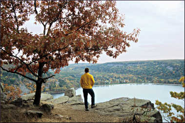
Devil's Lake State Park in south-central Wisconsin
© Beth Gauper
There's hardly a place in this park that doesn't have a view, but walk along the West Bluff Trail for the easiest and best views of the lake and surrounding Baraboo Hills.
At overlooks, you'll stand on slabs sof lick pink quartzite, once the sand at the edge of a red sea. Plaques explain that an ancient river cut the canyon below but was plugged by debris carried by the last glacier, causing the rise of the spring-fed lake.
The former riverway still can be seen plainly, stretching into the horizon.
In fall, this park retains colors into the third week of October. For more, see The divine Devil's Lake.
Eagle Bluff in Door County's Peninsula State Park
Shore Road, which winds through very popular Peninsula State Park between Fish Creek and Ephraim, leads to the wooden Eagle Tower.
From it, you'll get a panoramic view of the bay, Horseshoe Island and Ephraim, its white steeples a gleaming white.
You can also get nice views by hiking the 2-mile Eagle Trail loop from the overlook or by touring the nearby Eagle Bluff Light, built on the bluff in 1868. In fall, tours are given daily through mid-October.
For more, see Fall in Door County.
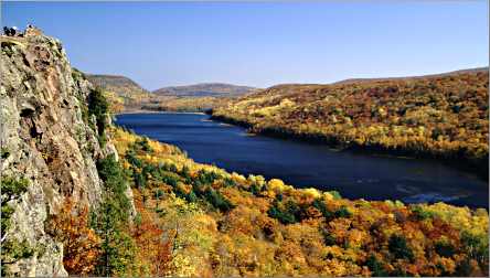
Lake of the Clouds overlook in the Porkies
© Torsten Muller
Many people come to Porcupines Mountains Wilderness State Park on Michigan's Upper Peninsula just to see this view. It's especially lovely in fall, when the leaves light up in old-growth forest that's considered the biggest and best of its kind east of the Mississippi.
There's a brief walk from the parking lot to the overlook 300 feet above Lake of the Clouds, from which the Carp River winds away into the horizon.
For more, see Afoot in the Porkies.
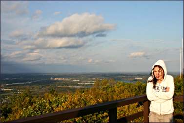
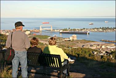
Enger Park and Skyline Parkway in Duluth
There are many spectacular views along Skyline Parkway, a 25-mile Minnesota scenic that follows terraces that once were the beaches of Glacial Lake Duluth, now Lake Superior.
One of the easiest overlooks to find is Enger Park, where the lighted, 60-foot bluestone Enger Tower is one of Duluth's best-known landmarks.
There's a great 360-foot view from the tower, but also from the rock outcroppings at the edge of the bluff, just beyond the parking lot.
© Beth Gauper
There's a pavilion and benches where you can sit for hours, looking down at the Aerial Lift Bridge and watching a steady stream of 1,000-foot lakers and oceangoing salties heading into the harbor for loads of grain, coal and taconite.
For sheer interest, it's rivaled only by Wisconsin's Interstate State Park and its view of the Dalles of the St. Croix, always crawling with rock climbers, kayakers and excursion boats.
On the west end of Skyline Parkway, there's another great view from Bardon's Peak. Visitors can see everything from the St. Louis River to Lake Superior, including the Oliver Bridge, the former site of the giant U.S. Steel plant and, directly below, the company town of Morgan Park, named for tycoon J.P. Morgan.
On the east end, there's a panoramic view of Lake Superior and East Duluth from Hawk Ridge — though this time of year, most people there are looking up, not out.
For more, see Duluth's Skyline Parkway.
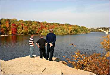
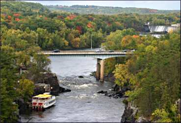
Interstate State Park in St. Croix Falls, Wis.
© Beth Gauper
From this park's Pothole Trail, the first thing you'll do is look down. The trail is named for the cylindrical holes drilled into solid rock by swirling pebbles at the end of the last Ice Age, and they're a sight to see.
But the action is on and around the St. Croix River. Paddlewheelers churn to and from Taylors Falls, taking tourists past the Old Man of the Dalles and Elephant's Head formations.
Canoeists and kayakers paddle the river, and rock climbers scramble up and down the cliffs on the Wisconsin side.
Tourists cross a rock arch to Angle Rock, where the river makes a sharp turn that, in 1886, caused a 3-mile-long logjam that took 200 loggers six weeks to clear.
Keep an eye on the white pines along the river; bald eagles often perch there.
The best overlooks on the trail are just a few yards from the park drive. It's also the western trailhead of the Ice Age National Scenic Trail, which winds 1,000 miles across Wisconsin.
For more, see Sightseeing on the St. Croix.
Itasca State Park in northern Minnesota
© Beth Gauper
In this beloved park, home of the Mississippi River's headwaters, it's just a short walk on the Aiton Heights trail to the fire tower. There's a parking lot just off Wilderness Drive.
For more, see The people's park.
Brockway Mountain Drive on the Keweenaw Peninsula
This nine-mile drive along the raised spine of Michigan's Keweenaw Peninsula, lined by stonework walls built by the Civilian Conservation Corps in 1933, is famous for its views of Lake Superior and interior lakes.
From Eagle Harbor, the drive rises to a wind-whipped overlook, with plaques and gift shop. Often, you can spot an ore boat on the lake.
There's another overlook just before the drive descends into Copper Harbor; take a minute to admire the view of Lake Fanny Hooe, the harbor and the Copper Harbor Lighthouse.
For details, see Copper Harbor refuge.