Minnesota's scenic byways
Hit the road for a glimpse of the state's most engaging spots.
© Beth Gauper
The corner of Third Avenue and U.S. 2 in Grand Rapids doesn't exactly look like the edge of the wilderness.
The Blandin Co. paper mill is across the highway, its smokestacks sending plumes of white smoke into the air. Trucks rumble past, en route to North Dakota or Duluth.
But this corner is the beginning of the Edge of the Wilderness drive, Minnesota's first National Scenic Byway.
Along its 47 winding miles — locals called it Highway Loop-de-Loop — it passes lakes and bogs plus an old iron-ore mine, an old CCC work camp, logging villages, the Laurentian Divide and a giant steel mosquito.
You might not know it was there if not for the scenic byways program, which includes national-forest and state byways.
Nearly every Minnesotan knows about the North Shore, also a national scenic byway.
But there are 20 more designated drives, and they all give motorists a good excuse to get off the beaten path and explore.
Trip Tips: Minnesota's scenic byways
America's Byways provides information about byways in other states, including two in Iowa, three in Michigan and seven in Illinois.
In Wisconsin, the Rustic Roads program includes more than 115 short but scenic stretches. For more, see Wisconsin's Rustic Roads.
National scenic byways in Minnesota
Edge of the Wilderness: 47 miles between Grand Rapids to Effie through Chippewa National Forest.

© Beth Gauper
For more about Grand Rapids, see Lumberjacks and legends.
Great River Road: 562 miles along the Mississippi, from its headwaters in Itasca State Park to the Iowa border.
For more, see Mississippi River Valley stories and Great River Road stories.
Grand Rounds: 53 miles in Minneapolis, along the chain of lakes and Mississippi River. It's also great for bicycling; see Biking in Minneapolis.
Gunflint Trail: 57 miles from Grand Marais to road's end at the Boundary Waters Canoe Area Wilderness.
For more, see Adventure on the Gunflint Trail.
Historic Bluff Country: 88 miles from I-90 to La Crescent on the Mississippi River, following Minnesota 16 and the Root River through scenic bluffland.
For more, see Bluff-country byways and other Bluff-country stories.
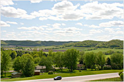
Minnesota River Valley: 287 miles along the Minnesota River from Belle Plaine on U.S. 169 west to Browns Valley, on the South Dakota border. It passes spots made prominent by the Dakota Conflict of 1862.
For more, see River with a past.
North Shore: 154 miles along Lake Superior, from Duluth to the Canadian border. This is by far the favorite drive of Minnesotans.
For more, see Escape to Minnesota's North Shore and other North Shore stories.
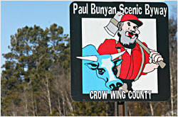
Paul Bunyan: 54 miles on two loops through lake country north of Brainerd, through Crosslake and Crow Wing State Forest.
For more, see The buzz on Brainerd and Bicycling the Bunyan.
National forest scenic byways in Minnesota
Avenue of the Pines: 46 miles from Deer River to Northome on Minnesota 46, through Chippewa National Forest.
© Beth Gauper
Lady Slipper: 28 miles from Cass Lake to Blackduck on county roads 10 and 39, through Chippewa National Forest, 218-335-8600.
Superior National Forest: 54 miles from Aurora to Silver Bay on county roads 110, 16, 16, 4 and 5.
Minnesota scenic byways
Apple Blossom: 17 miles along a ridge south of Winona, past Great River Bluffs State Park to La Crescent, with panoramic views of the river.
Glacial Ridge Trail: 245 miles around central Minnesota lakes country, passing four state parks on the route from Willmar to New London, Glenwood, Sauk Centre and Alexandria.
For more, see Little Crow lakes and Alexandria's enigma.
King of Trails : 414 miles along U.S. 75 down Minnesota's western flank; the route continues to the Gulf of Mexico.
Lake Country: 88 miles along busy Minnesota 34 from Detroit Lakes to Walker, with a spur on U.S. 71 from Park Rapids to Itasca State Park.
The Heartland State Trail roughly parallels the byway from Park Rapids to Walker.
For more, see Towns of the Heartland Trail.
Lake Mille Lacs: 68 miles around Minnesota's second-largest inland lake.
For more, see Life on Mille Lacs.
Otter Trail: 150-mile loop past Fergus Falls, Pelican Rapids, Battle Lake and Maplewood and Glendalough state parks, with many giant roadside mascots. Don't miss Vining, Phelps Mill or Inspiration Peak.
For more, see Otter trail country.
© Beth Gauper
St. Croix: 123 miles from Afton to Sandstone along the St. Croix River, past many state parks.
For more, see A sortie along the St. Croix.
Shooting Star: 31 miles along Minnesota 56 in southern Minnesota, between I-90 to Le Roy past Lake Louise State Park. It's known for its prairie wildflowers.
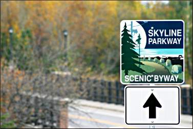
Skyline Parkway: 25 miles on the ridgeline above Duluth, from Elys Peak to Spirit Mountain, Hawk Ridge and the Lester River. The section east of Hawk Ridge is closed in winter.
For more, see Duluth's Skyline Parkway.
Veterans Evergreen Memorial: 50 miles from Banning State Park to Duluth along Minnesota 23, a peaceful alternative to Interstate 35.
Waters of the Dancing Sky: 229 miles from Hallock through Roseau, Warroad and Baudette to International Falls and Voyageurs National Park, passing Zippel Bay and Lake Bronson state parks.
The parks and the stretch between Greenbush and Baudette are famous for June displays of orchids, including yellow moccasins and showy lady's slippers. In late summer, you'll see sunflower fields.
For more, see the story Waters of the dancing sky.